20-minute video production showing the hands-on aspects of Participatory 3D Modelling (P3DM). The video supports all practical aspects of P3DM described in the resource book "Participatory 3-Dimensional Modelling: Guiding Principles and Applications" and documents in detail an exercise conducted within the Pu Mat National Park, a protected area in Vietnam.
Thanks to voluntary translations :-) the video is now available with subtitles in Arabic, Fijian, Italian, Swahili and Turkish. More languages to come soon.
If you are interested to embed this video on your web site or blog, follow this link.

Monday, December 22, 2008
PGIS/PPGIS Global Forum - Year's end summary and greetings
The PGIS/PPGIS Global Forum [ppgis] has steadily grown, reaching a total of 1346 members as of today. Approximately 560 messages have been posted this year. The Spanish [ppgis-sp] chapter launched in 2007 has grown to a total of 113 members, while the French [ppgis-fr] and Portuguese [ppgis-pt]-speaking communities have been languishing (sorry!). Each chapter operates independently and is managed by groups of 4-6 moderators. All chapters can be reached and joined via the PGIS/PPGIS gateway http://www.ppgis.net/
On the PGIS/PPGIS Global forum [ppgis] postings and debates have been rich in terms of content and innovation. Year 2008 started with a debate on PGIS / PPGIS practice for conflict management. Amidst announcements and postings for sharing information or seeking advice, debates focused the use of PGIS practice in the development sector, understanding of PGIS vs. PPGIS, partnerships and success in PGIS, PPGIS and Vulnerability, PGIS/PPGIS indicators, fundraising for PGIS projects, P-mapping certification, PGIS for disaster response, measuring the appropriateness of PGIS, free and open source desktop GIS, land tenure before and after disasters, confidentiality of data, climate change & Google Earth, mapping with Mobile Indigenous Peoples, using P3DM, community-based mapping courses, participative methods for SDI construction, PPGIS as a participatory health promotion strategy, and CyberTracker, amongst others.
In 2008, CTA initiated a project entitled “Support the spread of good practice in generating, managing, analysing and communication spatial information”. The project is financially supported by CTA, the International Fund for Agricultural Development (IFAD), IKM Emergent and the Ford Foundation Brazil. The project The project’s overall objective is to increase the capacity of indigenous and other marginalised peoples to engage in effective policy dialogue and advocacy. The output of the initiative will consist in a freely available Multilingual, Modular, Multimedia Training Kit to be used in face to face capacity building events. The kit will be published in English and Spanish. Brazilian-Portuguese and French versions will follow. In the context of this project, CTA will soon launch a Photo Competition. More information on the project and the competition will soon be published on http://pgis.cta.int/
Here are a some other initiatives where members of this list are invited to participate and contribute:
- PPGIS/PGIS Group on LinkedIn (LinkedIn is a social- networking site used by professionals);
- http://www.ppgis.eu/ : a highly specialized Custom Search Engine reflecting knowledge and interests in PGIS/PPGIS practice and science;
- P3DM Where? is an interactive world map based on Google Map technology operated collaboratively by participatory mapping practitioners and serves for locating "participatory 3D Modelling (P3DM) exercises" worldwide;
- A Participatory Translation Initiative has been launched among members of this list last October for translating the subtitles of a video on P3DM. So far translations have been completed by volunteers for the following languages: Arabic, Fijian, Italian, Swahili and Turkish. Other 18 languages are currently being translated. The video with subtitles can be embedded on any blog of website using a code which can be obtained on the video page under the heading “share”;
- “Palawan Endangered” this recently launched initiative consists in a campaign aimed at raising awareness on the in the ongoing and planned mining activities in Palawan (and the whole of the Philippines). The campaign will make use of web 2.0 tools including Google Earth, Google Docs and Video Sharing sites and seeks volunteer contributions. Interested parties should contact palawan.endangered[at]gmail.com;
- On PPgis.Net there is a regularly updated collection of books dealing with PGIS/PPGIS practice. If you would like to recommend additional titles you should write to ppgis[at]ppgis.net
- The PGIS/PPGIS Web Ring is a “ring of websites” sharing common interests in collaborative geospatial information management practice aimed at supporting conservation and development, sustainable natural resource management, customary property rights and peer-to-peer communication. If you run a site dealing with PGIS/PPGIS practice and are interested in joining the ring, please follow this link (for webmasters).
Please note that DGroups, the platform hosting this list, is in the process of being transferred to a more up-to-date environment (Dgroups 2.0). This may cause some temporary disruption in the service. At present all postings are found here . (This may change when this list will be migrated on the new platform).
Selected collections of annotated links are found on http://www.ppgis.net/ You can use all features of this community platform after login (join) by entering your e-mail address and password. In case you forgot your password, you can retrieve it via this link.
The [ppgis] forum and related web site http://www.ppgis.net/ are run and moderated on a voluntary basis with no external financial support. Many thanks to all contributors and moderators. Thanks again for all contributions, messages behind the scene, encouragements and suggestions for improvement. Best regards and best wishes to all of you for a successful and exciting year 2009.
Giacomo Rambaldi
Moderator and List Administrator
http://www.ppgis.net/
http://www.iapad.org/
http://participatorygis.blogspot.com/
Thursday, December 18, 2008
Digital Mapping Advocacy Project - Call for Volunteers
The Philippines is one of the 17 countries in the world with the richest biodiversity. In March 2006, Philippine President Gloria Macapagal-Arroyo called for a revitalization of mining nation-wide. As of the present, approved mining claims already cover almost half a million of hectares of land. Open-pit and strip mining for nickel results in the flattening of mountain tops, in the plundering of forest and in the production of vast amounts of tailings that contaminate freshwater sources and the sea.
Recently, from a premiere tourist destination, Palawan - the richest biodiversity hot spot in the country - has become one of the most attractive mining investments destinations.
The island is part of the "Man and Biosphere Reserve" program of UNESCO and hosts 49 animals and 56 botanical species found in the IUCN Red List of Threatened Species. As of now, there are more than 300 mining applications also covering forested watersheds and protected areas customarily managed by indigenous communities belonging to three main ethnic groups: Pälawan, Tagbanua and Batak. The other communities affected are fisher folks and farmers. A mission of the Centre for Biological Diversity (CBCD) of the University of Kent (UK) with the support of the Christensen Fund (TCF) and of the Royal Anthropological Institute (RAI) visited Palawan between July and September 2008. Audiovisual documentation on the impact of mining, including interviews and discussions with indigenous people, farmers, NGOs representatives and politicians was acquired.
Initial plans were discussed with relevant stakeholders on how to bring the case of Palawan to international attention. As a result of these discussions, a request has been made to Peoples and Plants International (PPI) -- a US based non-profit organization - to provide additional expertise and institutional backing to this project, while establishing linkages with Google Earth Outreach .
We are now inviting volunteers experienced in working with Google Earth and interfacing it with Google Docs to help us developing an awareness raising layer. Geo-coded data compiled on the ground in the form of multimedia, images and reports and other data like the boundaries of mining applications, protected areas, and other should be visualized on Google Earth.
The resulting mashup would serve to raise awareness among a wider international audience, on the impact of mining on the forest environment and 'traditional' communities of Palawan Island.
This is to facilitate connections and networking between global advocacy initiatives and locally grounded efforts. It is expected that this project will ultimately lead to more effective strategies for opposing irresponsible mining, while amplifying the impact of Palawan grass-root and indigenous people's voices both nationally and internationally.
Interested volunteers should send an e-mail to: palawan.endangered@gmail.com
Source: PPgis.Net list
Sunday, November 23, 2008
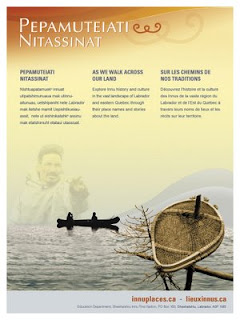
Innu Place Names Website
Labrador Innu launched the first comprehensive cultural website dedicated entirely to Aboriginal place names. Called Pepamuteiati nitassinat (‘As We Walk Across Our Land’), the website gives access to over 500 Innu place names in Labrador, as well as stories, photos, and video clips associated with the names. The website can be explored at http://www.innuplaces.ca/ . Innu Nation Grand Chief, Mark Nui, said, “Place names are very important to our people because they are a gateway to our history on the land. Many younger Innu who have gone through the provincial educational system have never learned these names. We hope that the website will help them learn about their culture and history.”
 Lots of place names in Labrador come from the Innu (e.g. Minipi-Lake from Minai-nipi,
meaning ‘burbot lake’), but others were given by pilots, mining companies, settlers and outfitters and were imposed on places that already had Innu names. The website will enable the Innu and members of the general public to start using the Innu place names, to learn about the meaning of the names and how to pronounce them.
Other Aboriginal groups have been doing place name research over the years, and some are in the process of publishing their own websites (e.g. James Bay Cree and Norwegian Sámi). However, Pepamuteiati nitassinat is the first, comprehensive one put on line to date.
Grand Chief Nui pointed out that “Over thirty years of research with our Elders went in to this website. It’s a gift from our Elders to younger Innu people. It’s part of our Elders’ legacy. It’s also an important part of our intangible cultural heritage that will help educate people about the richness of our history and traditions.”
The website was made possible by contributions from many institutions and agencies including multimedia company Idéeclic, Environment Canada, Parks Canada, Memorial University Linguistics, and Canadian Boreal Trust. The Innu Nation wishes to acknowledge the generous financial support of the Department of Canadian Heritage through Canadian Culture Online.
Lots of place names in Labrador come from the Innu (e.g. Minipi-Lake from Minai-nipi,meaning ‘burbot lake’), but others were given by pilots, mining companies, settlers and outfitters and were imposed on places that already had Innu names. The website will enable the Innu and members of the general public to start using the Innu place names, to learn about the meaning of the names and how to pronounce them.
Other Aboriginal groups have been doing place name research over the years, and some are in the process of publishing their own websites (e.g. James Bay Cree and Norwegian Sámi). However, Pepamuteiati nitassinat is the first, comprehensive one put on line to date.
Grand Chief Nui pointed out that “Over thirty years of research with our Elders went in to this website. It’s a gift from our Elders to younger Innu people. It’s part of our Elders’ legacy. It’s also an important part of our intangible cultural heritage that will help educate people about the richness of our history and traditions.”
The website was made possible by contributions from many institutions and agencies including multimedia company Idéeclic, Environment Canada, Parks Canada, Memorial University Linguistics, and Canadian Boreal Trust. The Innu Nation wishes to acknowledge the generous financial support of the Department of Canadian Heritage through Canadian Culture Online.
History of the website project
- The Innu place names available on the website were collected in the context of a number of research projects going back to the mid-1970s.
- The biggest source of place names for the site is a 1980 mapping project. Over 500 maps at 1:50,000 scale were cut and taped together to form two giant maps. One was laid on the gym floor at Peenamin McKenzie School in Sheshatshiu and the other in the parish hall in the former community of Davis Inlet. Older hunters were invited to walk about on these maps to point out the locations of place names as well as old travel routes, camp sites, caches, birth places and good hunting and fishing places.
- Only seven of the 34 older hunters who worked on the 1980 mapping project are still living.
- A great deal of validation work was undertaken with respect to the places names which was done by ethnolinguist, José Mailhot, and anthropologist Peter Armitage, with the collaboration of Marguerite MacKenzie, Sebastien Piwas, George Gregoire, Jean-Pierre Ashini, Basile Penashue, Tony Penashue, and several Innu Elders.
- Project managers for the website project were Kanani Penashue and Peter Armitage.
What’s on the website
- The site features a searchable database of over 500 Innu place names.
- Each place name record in the database contains information about the meaning of the name, how to pronounce it, and its location. Site users can click on an audio icon to hear the pronunciation of each place name.
- The site has an interactive map showing the locations of the place names.
- Background information on how Innu place names are constructed is presented.
- Video clips and photographs show people what the named places look like or document land use activities there.
- Audio narratives from Innu Elders and youth tell stories about events and people associated with certain place names.
- Future phases of the website will add more place names, video clips, photos, and audio stories.
Source: Press relase by Natuashish (Labrador), 21.11.08
Tuesday, November 18, 2008
CGDI Interoperability Pilot
The CGDI IP project developed a OGC Web Feature / Web Map Service partnership network across Canada, demonstrating a variety of scenarios involving closest-to-source update, access and use of public geospatial data. This video highlights the collaboration, the concepts and technology behind the network.
Monday, November 10, 2008
ESRI GIS Grants for U.S. 4-H Programs
The 2009 ESRI geographic information system (GIS) technology grants for the U.S. 4-H Youth Development Program are open for application until December 1, 2008. GIS greatly improves the ability of educators, students, and their institutions to answer personal and community questions with local and global implications.
With its annual grant program, ESRI has awarded 4-H clubs in more than 600 counties with ArcView and ArcPad software and Virtual Campus training. Three different types of grants are offered: Getting Started with GIS and GPS; Introduction to GIS for 4-H; and Intermediate GIS for 4-H.
For 2009, ESRI has again joined with American Forests, a nonprofit citizens’ conservation group, to provide 4-H clubs with a grant opportunity. Clubs that have successfully fulfilled the requirements of the Introduction to GIS for 4-H grant can acquire advanced functionality for their community service projects through the Intermediate GIS for 4-H grant. ESRI will equip these clubs with Youth Club Licenses for ArcGIS 3D Analyst or ArcGIS Geostatistical Analyst extensions. American Forests will provide clubs that are working on a forestry project with the CITYgreen extension to ArcGIS.
“This grant program is an excellent way for 4-H clubs in the United States to access the latest geospatial technology,” said Esther Worker, youth and community mapping manager, ESRI. “GIS will help further the 4-H mission of integrating science, engineering, and technology into youth programs as well as provide an excellent way for youth to investigate and understand their communities and their world. We encourage 4-H clubs to apply for this opportunity to advance their projects in a creative and telling way.”
“It is amazing what kids learn from the environment when they use GIS,” said Mike Lehman, CITYgreen software director, American Forests. “CITYgreen fosters a higher level of thinking and helps kids understand what is happening to the environment around them.”
The American Forests environmental education program provides students with a real-world learning experience while offering teachers an innovative and organized program for teaching science, math, and GIS. American Forests’ CITYgreen software conducts complex analyses of ecosystem services and creates easy-to-understand reports. The software calculates dollar benefits for the services provided by the trees and other green space in a specific area.
4-H geospatial research and community mapping projects help young people build on their science and technology knowledge and skills as well as their personal outlook and career aspirations. These projects also help both youth and adults improve decision making in their communities and help strengthen local economic, social, and environmental well being.
The software and training materials for grant recipients will be delivered to the 4-H clubs in early 2009.
More information about the ESRI GIS for 4-H (U.S.) program, grants, and application process can be found at http://www.esri.com/4-H.
Questions can be directed to Esther Worker at eworker@esri.com or by calling 303-449-7779, extension 8216.
Sunday, November 09, 2008
Indigenous Peoples and Protected Areas: Conservation Through Self-Determination
Indigenous Peoples and Protected Areas: Conservation Through Self-Determination
Annual Meeting of the Association of American Geographers
Las Vegas, Nevada; March 22-27, 2009
Co-sponsored by the Indigenous Peoples Specialty Group, the Cultural and Political Ecology (CAPE) Specialty Group, and appropriate regional specialty groups
Session(s) organized and chaired by Stan Stevens, Associate Professor of Geography, Department of Geosciences, University of Massachusetts, Amherst 01003
Contact: sstevens@geo.umass.edu
Deadline to contact session chair with abstract: October 9, 2008
Conference registration and abstract deadline: October 16, 2008
Papers are invited for an AAG session on the interwoven politics and political ecologies of Indigenous rights and protected area-based conservation. This is the sixth consecutive year that the Indigenous Specialty Group has sponsored and organized such sessions at the AAG annual meetings. These sessions provide a continuing venue at the AAG for discussion of conservation, difference, and social justice and for analyses of the diverse political ecologies created by the establishment of protected areas by Indigenous peoples, states, and NGOs in Indigenous peoples' territories. Participants in this year's session are invited to join previous participants in contributing theoretical and case study chapters to an edited book. Both theoretical and case study contributions are welcome.
The organizer is particularly interested in papers on the following topics:
- New Paradigm Protected Areas. Establishment, operation, and effectiveness of inclusive, participatory, new paradigm protected areas. These may include diverse types of protected areas in which Indigenous peoples' land use and participation in management is recognized.
- Critiques of Old Paradigm Protected Areas. Analyses of coercively imposed exclusionary "wilderness" or Yellowstone-model protected areas and "fortress conservation" from the standpoints of violations of human/indigenous rights; displacement; loss of access to and/or management of natural resources, cultural resources, and cultural sites; accompanying changes in land/water use and management; and consequent ecological change.
- "Hand-backs," "Hand overs," and other Reconciliation and Restitution. Case studies of redress, compensation, or restitution for past injustices against Indigenous peoples caused by the creation or management of protected areas.
- False Representations of "Progressive" Protected Areas. Analyses of protected areas which have inappropriately represented as participatory and community-based by states, intergovernmental agencies, or NGOs .
- Rights-Based Conservation. Analyses of protected area governance and management in cases where this is explicitly based on recognition of constitutional, human, and/or Indigenous Rights.
Saturday, September 20, 2008
Management Change at UNOSAT
According to Alain Retiere, Director of UNOSAT, the programme has reached the required maturity to become independent from the administrative management of UNOPS and become fully part of the new United Nations Institute for Training and Research that the Secretary-General has entrusted ASG Dr. Carlos Lopes to lead together with the United Nations Staff College, in full coordination with the United Nations University. This process will bring to UNOSAT further training activities, which will increasingly be carried out by the United Nations under a unified management. UNOSAT will enjoy the additional opportunity of developing applied research on satellite solutions, and consolidate the UN training offer on satellite applications for key issues ranging from emergency response to sustainable recovery.
In parallel, UNDP has decided to mainstream satellite applications throughout its network of 166 country offices supported by its 40 regional technical centers to help face the main development challenges. A new trend is emerging within the “territorial approach to development”, where a more local and decentralized way of supporting development efforts in most vulnerable countries is being applied. Although all dimensions of the UNDP development agenda will benefit from mainstreamed satellite applications, environment and energy is the area that has been selected as key entry point, considering the urgent need to help local communities to face climate change challenges with the most appropriate tools including satellite and GIS applications.
In parallel, UNDP has decided to mainstream satellite applications throughout its network of 166 country offices supported by its 40 regional technical centers to help face the main development challenges. A new trend is emerging within the “territorial approach to development”, where a more local and decentralized way of supporting development efforts in most vulnerable countries is being applied. Although all dimensions of the UNDP development agenda will benefit from mainstreamed satellite applications, environment and energy is the area that has been selected as key entry point, considering the urgent need to help local communities to face climate change challenges with the most appropriate tools including satellite and GIS applications.
Saturday, September 06, 2008
Information and Communication Technology and Peacebuilding: Summary of a Workshop
Those who would use information and communication technology (ICT) in the cause of peace need to be cognizant of the risks as well as the benefits. ICT can facilitate positive dialogue but also hate speech. It can be used to fight corruption but also facilitate it. Simply giving people more information does not necessarily lead to predictable or positive results. As people become more informed, they may become more motivated to change their circumstances and to do so violently.
On December 14, 2007, the National Academy of Engineering (NAE) convened a group of experts in diverse fields to consider the role of ICT in promoting peace and conflict resolution. The one-day workshop was designed to consider current and emerging technologies and strategies for employing them in conflict management and diplomacy. Giacomo Rambaldi presented a case study on "GIS and Participatory 3-D Modeling in Land-Use Negotiation" . The workshop also aimed to explore how organizations with a role in promoting peace, like the U.S. Institute of Peace, can most effectively leverage technology in carrying out their missions.
"Information and Communication Technology and Peacebuilding: Summary of a Workshop" reviews the group's discussions on number of key issues, illuminates certain practitioner needs, and suggests possible next steps.
The proceedings can be downloaded for free via this link.
Sunday, August 31, 2008
African Indigenous Peoples’ Workshop on effective use of GITs and ICTs in advocacy
 I have just come back from Namibia where I attended the "African Indigenous Peoples’ Workshop on effective use of GITs and ICTs in advocacy" (Windhoek, 25-28 August 2008)
The workshop has been organised by the Indigenous Peoples of Africa Coordinating Committee (IPACC) with technical and financial assistance provided by the Technical Centre for Agricultural and Rural Cooperation (CTA), ERMIS-Africa, Cybertracker Conservation, Shalin Ry and the Rainforest Foundation UK.
Indigenous African leaders and technology intermediaries have shared experiences on how geo-spatial information technologies (GIT) are used by indigenous peoples to express their traditional ecological knowledge to decisions makers for the purposes of securing recognition and rights. Key case studies presented included participatory mapping by ToCADI and San groups in Botswana, Participatory 3 Dimensional Modelling (P3DM) by hunter-gatherer peoples in Kenya, GPS-based mapping experiences from Cameroon, DR Congo, Namibia and South Africa.

The workshop included also capacity building sessions on the use of Cybertracker and online mapping (Google Earth and Google Maps) and web 2.0 (web2fordev) applications like blogging, online video sharing, and use of electronic discussion groups including [ppgis]).
Web 2.0 applications have been presented and adopted as adds-on to GIT in support to networking, communication, alliance building and remote collaboration for advocacy.
Tuesday, August 26, 2008
African Indigenous Peoples’ Workshop on effective use of ICTs in environmental advocacy
Starting on August 26, 2008 IPACC is holding a 3 day workshop outside of Windhoek Namibia for 40 indigenous African leaders to review case studies of how geo-spatial information technologies can be used by indigenous peoples to express their traditional ecological knowledge to decisions makers for the purposes of securing recognition and rights. The workshop will also look at the role of the internet (Web 2.0) in helping promote good advocacy and communication. The event is co-hosted and presented by the Technical Centre for Agricultural and Rural Cooperation (CTA), the Rainforest Foundation UK, ERMIS Africa, Cybertracker Conservation and Shalin Ry.
Tuesday, August 12, 2008
Rebecca Moore from Google Earth Outreach, Geneva layer showcase
Rebecca Moore, Head of Google Earth Outreach, demos 2 partner layers at the launch of Google Earth Outreach in Geneva: UNHCR's refugee layer and the Elders' "Every Human Has Rights" layer.
Wednesday, August 06, 2008
PPGIS.net on LinkedIn to foster community development among pgis/ppgis practitioners
Since DGroups, the platform hosting [ppgis] offers limited opportunities for members to learn about each other and to e.g. get together on a country basis. Considering this limitations and the opportunities offered by emerging web 2.0 applications, I have created a parallel peer2peer space on LinkedIn. LinkedIn is a social- networking site used by professionals.
Joining this new space will allow you to easily identify and establish contact with other [ppgis] members.
The goal of this new space is to help [ppgis] members:
To easily identify members of the [ppgis] network, learn more about them and eventually establish personal contact;
Accelerate careers/business through referrals from [ppgis] Group members;Put a face and a professional curriculum behind a name or an e-mail address
Below is a short vide explaining how LinkedIn works:
Tuesday, July 08, 2008
Ethics and Anthropological Research and Practice
In this concise introduction to anthropological ethics, Whiteford and Trotter provide current and prospective researchers and practitioners with a solid foundation of ethical concepts and issues, including respect for persons, beneficence, and justice. They take into account both national and international discussions and practice of ethics. Together with equipping readers with essentials about ethics, the authors explore ethical problems common among anthropologists. Ethical challenges often arise from the unanticipated consequences of a research design, from conflicts among stakeholders, or from the clash of two positive ethical principles--when adherence to one of the principles may violate another. Functioning both as a capstone and a learning tool, the last chapter presents a real-life ethical dilemma and introduces readers to a detailed problem-solving guide. Other pedagogical aids include end-of-chapter questions that inspire deeper thinking about ethical principles, issues, and considerations, and five brief ethical dilemma cases for further enrichment and study. In this concise introduction to anthropological ethics, Whiteford and Trotter provide current and prospective researchers and practitioners with a solid foundation of ethical concepts and issues, including respect for persons, beneficence, and justice. They take into account both national and international discussions and practice of ethics. Together with equipping readers with essentials about ethics, the authors explore ethical problems common among anthropologists. Ethical challenges often arise from the unanticipated consequences of a research design, from conflicts among stakeholders, or from the clash of two positive ethical principles--when adherence to one of the principles may violate another. Functioning both as a capstone and a learning tool, the last chapter presents a real-life ethical dilemma and introduces readers to a detailed problem-solving guide. Other pedagogical aids include end-of-chapter questions that inspire deeper thinking about ethical principles, issues, and considerations, and five brief ethical dilemma cases for further enrichment and study.
Friday, July 04, 2008
African Indigenous Peoples’ Workshop on effective use of GIT/ICTs in environmental advocacy
CTA is supporting an and IPACC-organised pan-African workshop of indigenous peoples' organisations / leadership to review case studies of participatory mapping and other geospatial information technology (GIT) applications by indigenous peoples related to their intangible / oral traditional ecological knowledge, and how this can be effectively used in advocacy, both directly on environmental / natural resource issues, but also on human and civil rights associated with lands, territories and cultural sustainability.
IPACC partner organisations will give feed back on P3DM application in three mountain forest communities. Southern Africa will relay experiences of using Cybertracker. Cameroon will give a presentation on forest mapping by communities and Botswana and Namibia will present their experience of mapping land use and natural resources.
There will be a report emanating from the meeting which will be made acailable on IPACC and CTA web sites. The workshop will take place from 26 to 28 August in Namibia. Indigenous delegates will be coming from Morocco, Algeria, Niger, Kenya, Tanzania, Gabon, Cameroon, Burundi, Botswana, Namibia and South Africa.
Friday, June 06, 2008
PGIS Curriculum Development Workshop
On 21 and 22 April 2008, CTA hosted a “Curriculum Development Workshop” as part of the project known as “Support the spread of good practice in generating, managing, analysing and communication spatial information”. The event brought together 35 people from different continents (Africa, Asia, Latin America, Northern America and Europe), all sharing a solid experience in participatory mapping and communication. The aim of the workshop was to kick-start the process which would lead to the production of a multilingual, multimedia and modular training kit on ‘Participatory Spatial Information Management and Communication”.
The output of the initiative is intended to increase the capacity of indigenous and other marginalised peoples to engage in effective policy dialogue and advocacy on issues related to the territory. Skills acquired through the deployment of the kit would ensure that indigenous and other marginalised communities are more effective in documenting, representing and communicating their spatial knowledge, while taking a high degree of control over the processes. The initiative is co-funded by CTA and IFAD. Development partners which committed additional resources to the project include the Indigenous Peoples of Africa Coordinating Committee (IPACC); International Institute for Geo-Information Science and Earth Observation (ITC), the University of British Columbia, Okanagan (UBC), UNOSAT and the Ford Foundation Brazil.
The direct beneficiaries of the project are technology intermediaries working in multidisciplinary teams and operating within institutions or organisations already committed to practicing participatory mapping and who are or would be required to deliver training on the practice, or facilitate the process in the field. Ultimate beneficiaries will be adopters from community-based organisations, non-governmental organisations, research institutions, academia, multilateral and bilateral development agencies and other development actors.
The English version of the kit is expected to be available in 2009 followed by versions in other languages.
Wednesday, May 21, 2008
Participatory Ethics - Special Thematic Issue of ACME
Vol 6 (3) of ACME (an International E-Journal for Critical Geographies) is dedicated to Participatory ethics. The 10 papers making up the issue are of interest to PGIS/PPGIS practitioners and researchers.
Sunday, May 18, 2008
Launch of the Participatory Mapping Training Kit announced
Participatory mapping and development practitioners, activists and researchers identified the lack of training materials as a major constraint in the spread of good participatory mapping / PGIS practice. An initiative launched by CTA and other development partners will lead to the production of a modular, multimedia and multilingual training kit for trainers. The kit will ensure that participatory mapping and communication practices evolve and spread in an ethically conscious manner, ensuring that indigenous and other marginalised communities are effective in documenting, representing, and communicating their spatial knowledge, while taking a high degree of control over the process. It is understood that good practice would add value and authority to local knowledge, facilitate inter-generational knowledge exchange, contribute to building and supporting a cohesive community identity, and support sustainable planning through collaborative decision-making.
Saturday, May 17, 2008
Participatory 3D Modelling among Ogiek Indigenous Peoples in Kenya
In their article "Through the Eyes of Hunter-gatherers: Participatory 3D Modelling among Ogiek Indigenous Peoples in Kenya" publlished on Information Development and now freely available for download, Giacomo Rambaldi and his colleagues describe a participatory process by which Ogiek Indigenous Peoples in the Mau Forest Complex in Kenya rendered their spatial memories through the making of a georeferenced three dimensional model covering part of their ancestral territory. The paper focuses on the course of action and related human dynamics which led to the production of the map legend via deep reflections and intense negotiations among elders of different clans. The 3D mapmaking process proved to be a catalyst in stimulating memory, articulating tacit knowledge and creating visible and tangible representations of the physical, biological and cultural landscapes of the area in the 1920s. Elaborating and negotiating agreement on the elements of the map legend allowed the participants to gain greater clarity on meanings and relationships between natural and cultural features. Once completed, the model selectively displayed both the tangible and the intangible heritage of the Ogiek people. The composition of the legend and the making of the model stimulated collegial learning and community cohesion. The process has been perceived as a milestone for Ogiek clans in terms of working together towards a common goal, and in realizing the value and potential authority of their spatial knowledge once it was collated, georeferenced, documented and visualized.
Monday, May 12, 2008
Google Maps and San Diego wildfires
When wildfires broke out in San Diego, broadcast station KPBS used the My Maps feature in Google Maps to easily create and share a map that provided real-time updates on the location of the fires and the status of evacuation shelters. The map received millions of views in just a few days.
Subscribe to:
Posts (Atom)