Monday, July 14, 2014

From Solomon Islands to the Philippines: my PGIS learning journey – QGIS introduction and P3DM in action (blog post 4)

On July 14, I was introduced to the free and open source software (FOSS), QGIS (QuantumGIS) to be used in the PGIS process. The REBUILD Project deploys two facilitators stationed at the San Dionosio office to implement the disaster rehabilitation program and livelihood strategy. Given these circumstances, I had the opportunity to work with the QGIS software for one day. Yet, Melvin was really helpful in teaching me the QGIS essentials and introducing me to a range of FOSS GIS software applications which are available on the web. In the end, my learning process of QGIS was much easier than expected. 

Later in the day, we went to a local fishing village to work with a non-indigenous community in Sua, a Barangay (administrative unit within a municipality) located along the San Dionisio coastline. Here, we conducted a community consultation meeting. While discussing the project with the community, the importance of collaboration and participation was evident. Last June 2014, the community worked together to construct a 3D map of their location. The 3D map was overlaid with a transparent plastic sheet, where information layers were depicted by locals. From the conversations I had, the map clearly indicates an effective medium for participatory discussions. It was nice to see a couple of local Barangay councillors and their secretary, partake in the consultation process with the REBUILD Project and Green Forum-Western Visayas staff. The active participation of the Barangay officials clearly demonstrated that the local government is aware and committed to address the damages caused by the super typhoon Yolanda. The facilitating team, however, pushed for a more direct cross-disciplinary and multi-sectoral participation from those higher up in the government. Furthermore, it was recalled that while constructing the 3D model, the residents of Barangay Sua managed to outline their administrative boundary and to come to an agreement about it with the neighbouring Barangay Tiabas.


Photo credit: Melvin Purzuelo
I was struck by the ease and dynamic use of the 3D model. It did not become redundant or obsolete, even if it had been completed a month earlier. On the contrary, it gained even more relevance as a reliable repository of geo-referenced data generated by and for the community. The enthusiastic reaction demonstrated by the local women to the consultation process was really inspiring. They shared their views and opinions with respect to the need to formulate a Disaster Risk Reduction Plan which could fit well with the Community Climate Change Adaptation Plan. Both plans will be appraised by the Barangay community. The villagers themselves attest that the model will be revisited at regular intervals based on their information needs or at the request of external agencies. From my perspective, the 3D model is a true representation of the communities’ spatial knowledge concerning the entire locality and the livelihoods of the residents. The 3D model enables residents to effectively respond to emerging / changing situations.

In observing the consultation process, I was reminded that strategic decisions must offer some degree of flexibility to avoid becoming irreversible when implemented. Therefore the decision making process should be based on quality data, adequate resources and sufficient time allocation. In my opinion, the P3DM process undertaken by this community met these requirements. During the consultation I noted that the model was constantly referred to when analysing and identifying the risks inherent to their current and future livelihoods and security. The model encourages the planning and distribution of future activities in collaboration with the facilitators.


Photo credit: Melvin Purzuelo
The instances of the consultation process that are so vivid in my memory are those linked to residents showing grief and despair when sharing their stories. They explicitly used the model to describe the impact of super typhoon Yolanda and recall the life-threatening ordeal they experienced. The typhoon caused devastation, loss of property and lives and internal displacement. It severely affected to the habitats essential to the community subsistence, and in general, the existence of a once prideful fishing community. In response to such terrible consequences, the facilitating team from the REBUILD Project used the model to revive some hope in the midst of community’s despair. By autonomously analysing their situation, its strengths, weaknesses, opportunities and threats, residents were able to plan a concrete way forward leading to regain to a 'normal' way of life.

Related posts by Wilfred Don Dorovoqa :

From Solomon Islands to the Philippines: My PGIS learning journey ... 
  • Blog post 5: Participatory data extraction and digitization
  • Blog post 4: QGIS introduction and P3DM in action
  • Blog post 3: Preparations and challenging encounters ()
  • Blog post 2: My expectations
  • Blog post 1: How it all started

Saturday, July 12, 2014

From Solomon Islands to the Philippines: my PGIS learning journey – Preparations and challenging encounters (blog post 3)

On July 11, I arrived in the Philippines, after a series of flights.


View Don's Journey in a larger map

I was welcomed at the Iloilo Airport by Melvin Purzuelo coordinator of the Green Forum-Western Visayas (my local mentor) and driven to my accommodation. I was briefed on the following day about the upcoming activities. On July 13, we went to the REBUILD Project Implementation Centre in San Dionisio. However we had to adjust our travel plans due to ensure travellers safety in an area which has been affected by super typhoon Yolanda. Recent past has witnessed a couple of incidents along the San Dionisio and Estancia Highway, involving armed robberies that included loss of lives. The locals believe that displaced people affected by the super typhoon Yolanda who are dispossessed and resort to illegal activities to sustain their living. We therefore were advised to be vigilant at all times and take the necessary precautions while travelling within the devastated area. Yet, the PGIS activities were maintained as planned.

While working with Melvin, I took the opportunity for preparing the base map for organising a similar 3D modelling exercise to the one back home in Solomon Islands. We discovered that the topographic maps of Solomon Islands are the work of the US air force, the same as in the Philippines. Considering that these maps were made decades ago, we realised that we had to improve them to be suitable for use in a P3DM process. I am exploring possibilities for establishing a long term partnership between our organisation in Solomon Islands and Melvin’s NGO in terms of PGIS activities.


Related posts by Wilfred Don Dorovoqa :

From Solomon Islands to the Philippines: My PGIS learning journey ... 
  • Blog post 5: Participatory data extraction and digitization
  • Blog post 4: QGIS introduction and P3DM in action
  • Blog post 3: Preparations and challenging encounters 
  • Blog post 2: My expectations
  • Blog post 1: How it all started

Friday, July 11, 2014

From Solomon Islands to the Philippines: my PGIS learning journey - My expectations (blog post 2)


What I expect to gain from the Philippines P3DM / PGIS process

My overall expectations for attending the Philippines PGIS are vast. However, I shall limit the list to the following:
  1. Gain practical knowledge and skills on how to facilitate and organise stakeholders into a participatory process and to know when and how to hand over the spatial information generating process to the concerned groups.
  2. Acquire practical skills on how to select and procure appropriate inputs for the manufacture of a physical 3D map.
  3. Gain hands on experience in the process of capturing and digitizing data displayed on the model and their processing for desired outcomes.
  4. Discover appropriate approaches to assess, manage spatial data and strategise on how to use them to help concerned communities achieve their objectives 
  5. Learn how to present the output to external agencies for various purposes including, e.g. policy making, disaster recovery, land use planning, land-based conflict management, climate change adaptation.
  6. Acquire facilitator skills – maintain a collaborative, neutral presence (not too dictatorial) when populating spatial information on the model map
  7. Align, impact and measure the outcome of a P3DM on the intended scenario.
  8. Improve and advance my capacity on the use of Web 2.0 and Social Media. 
During my participation, I believe that my theoretical knowledge on the subject will be enriched by practical experience and best serve an eventual replication of the P3DM process in Solomon Islands.

Follow the learning journey of Wilfred Don Dorovoqa, a member of the Padezaka tribe in Solomon Islands. 

Supported by CTA, Wilfred Don has embarked in a journey which will bring him from Sasamuqa Village to Estancia in the Philippines where he will participate in a participatory mapping exercise. Green Forum – Western Visayas, Inc. (GF-WV) in partnership with Aksyon Klima Pilipinas and the Rebuild Project is facilitating the implementation of a  Participatory 3-Dimensional Modelling (P3DM) process in an area which was severely affected by Supertyphoon Haiyan in November  2013. GF-WV is using the P3DM as an ICT tool for allowing communities to analyse their vulnerabilities and assist them in planning for reconstruction.


Related posts by Wilfred Don Dorovoqa :

From Solomon Islands to the Philippines: My PGIS learning journey ... 
  • Blog post 5: Participatory data extraction and digitization
  • Blog post 4: QGIS introduction and P3DM in action
  • Blog post 3: Preparations and challenging encounters
  • Blog post 2: My expectations
  • Blog post 1: How it all started

From Solomon Islands to the Philippines: my PGIS learning journey - How it all started (blog post 1)

My name is Wilfred Don Dorovoqa. I am a member of the Padezaka tribe in Solomon Islands. I am about to embark on a challenging learning journey and I thought it would be interesting to document and share it with people having similar interests and aspirations.

This is my first blogpost. More will follow.

I left Sasamuqa Village (S 7°02’18.49” E 156°45’54.33”) in the early hours of June 16, 2014 by OBM boat and arrived at Gizo (S 8°06’12.99” E 156°50’27.80”) that same day, a three to four hour journey by boat.  From there, I took a passenger boat for a two day journey to Honiara (S 9°25’52.13” E 159°57’33.57”), where I am today waiting for the trip to the Philippines.

How it all started: Embarking on the P3DM / PGIS learning journey

In 2009 I came across the concept of P3DM on the Internet, while I was searching customizable mapping resources for local spatial data entry that derived from non-technical / non-machine readable formats. I was captivated by the distinct nature and approach of the P3DM process, taking into account that at that time I was already familiar with the Participatory Rural Appraisal (PRA) concept. I assisted in a contracted PRA activity that aimed to identify and further develop livelihood measures for a localized World Wildlife Fund (WWF) conservation project based on four indigenous land owning groups of Choiseul Island, Solomon Islands, where I was holding a position as secretary for one of the groups. The conservation efforts were funded by the European Union , and led by the Ministry of Forestry in Solomon Islands.

Simultaneously, the Padezaka tribe, pursued its land based conservation initiative under a separate NGO in Solomon Islands called ‘Live and Learn’. The Padezaka tribe was eventually very fortunate to become a selected recipient of the Global Environment Facility (GEF) – Small Grants Programme funds coordinated by the United Nations Development Programme (UNDP) office based in Honiara, the capital city of Solomon Islands. As a member of the Padezaka tribe, I have very strong land and blood ties with the local community, and have been heavily involved in most of their conservation activities. The network of local protected areas attempts to conserve 17 percent of the highest priority terrestrial ecosystem of the Choiseul Island in adherence to the convention on biodiversity to which Solomon Islands is a signatory.

My search for mapping resources on the web was motivated by the fact that three conservation land units were under WWF conservation initiatives, including the Padezaka tribal land. Here, the conservation land units were all situated in the same segment of a significant freshwater system, locally known as the Kolobangara River. Major logging activities authorised by government, occurred further upstream while  government-endorsed WWF conservation initiatives were concentrated downstream. Indeed, upstream deforestation posed a significant threat to the livelihoods of local communities. It was a counteractive measure to monitor and moderate critical changes to the natural environment. Currently, all stakeholders involved need to come to an agreement to implement an alternative measure. One possible alternative is to produce a collaborative map with detailed land use that covers the entire watershed of the Kolobangara River.

Given this, my research eventually landed me on the front steps of the local provincial planning advisor’s house, an expatriate from New Zealand working for The Nature Conservancy (TNC) Solomon Islands Office. The planning advisor assisted the Choiseul government in provincial-wide planning, project implementation and monitoring. He was very helpful and promised to update me on any available opportunities that need expert assistance for a future P3DM exercise comprising the concerned land area. In anticipation, the Padezaka Tribe submitted a budget under the GEF-Small Grants Programme fund for a P3DM project in the Padezaka bio-diversity protected sites; to generate a well defined land use plan, consult, invite and include the contiguous land owning tribes for broad holistic land-based planning activities. This of course, will work if there is an environment conducive to collaborative planning that can systematically and coherently tackle the issue of the endangered watershed areas by creating a sectoral land and resource management plan in advance. We estimated that the availability of the P3DM opportunity would coincide with the disbursement and implementation of the external fund.

Our desire for P3DM does not materialise the Padezaka Conservation Project funds. These included GEF-Small Grants Programme funds that were mismanaged by the implementing NGO, which ceased to be operational whilst subjected to that same timeframe. WWF also closed its doors to the other four local land groups, perhaps due to the lapse of the funding contract. However, the Choiseul provincial advisor was true to his word and invited me to attend a P3DM introductory workshop in May 2012. It was jointly organized by the Technical Centre for Agricultural and Rural Cooperation (CTA), TNC and UNDP held in the Capital of the Solomon Islands. During this organised workshop, I repeatedly called on our provincial leaders in attendance to convene an extensive P3DM of the whole Island of Choiseul but was adhered not to.

Fundamentally, this is the dominant culture in PGIS practices found in some areas of the Southern hemisphere. In the Northern hemisphere, I believe the public is more proactive in using PGIS to enhance, empower and improve their way of life. At the very structure of our society there is a lack of proactive dimensions needed to engender a collaborative planning process that measures collective growth. This weakness is inherent to those tribes whose land comprises the noted watershed area. Furthermore, the National River Act was very ineffective in dealing with large scale natural resource extractions, because it had no clear provisions for specific social and natural environment safeguards. However, I am also fully aware of the fact that some methodologies and techniques incorporated into the PRA approach have limitations for discovering effective solutions in the midst of the large scale emergence of this environmental threat.

Related posts by Wilfred Don Dorovoqa :

From Solomon Islands to the Philippines: My PGIS learning journey ... 
  • Blog post 5: Participatory data extraction and digitization
  • Blog post 4: QGIS introduction and P3DM in action
  • Blog post 3: Preparations and challenging encounters ()
  • Blog post 2: My expectations
  • Blog post 1: How it all started

Thursday, July 10, 2014

She becomes more beautiful: Capturing the essence of Tobago Island for a better tomorrow


The Caribbean Natural Resources Institute (CANARI), the University of the West Indies (UWI), the Tobago House of Assembly, Division of Agriculture, Marine Affairs, Marketing and the Environment (DAME) and the Partners with Melanesians (PwM) facilitated the building of a Participatory 3D Model (P3DM) of Tobago Island from 28th September to 12th October 2012.

The model was used as a tool to incorporate and recognize local and traditional knowledge and values into decision making about climate change adaptation.

A training of trainers in facilitating participatory approaches, with participants drawn from the Caribbean Region, was executed concurrently with the building of the P3D model of Tobago. Participants in the Training of Trainers used participatory video to evaluate the effectiveness of the use of P3DM.

The project was funded by the Technical Centre for Agricultural and Rural Cooperation (CTA) and the United Nations Development Programme and the Global Environment Facility Small Grants Programme (UNDP GEF SGP).

Friday, May 23, 2014

A three-way dialogue on climate change

The peasant, the decision-maker, the researcher and Participatory 3d Modelling

In the numerous bus stations in N’Djamena, the capital of Chad, all passengers, arriving from other parts of the country, with their bag of worries, know where to find a sympathetic ear. Aladji Ibrahim’s steps lead him to Hindou Oumarou Ibrahim, the coordinator of AFPAT, an organisation which defends the rights of Bororos pastoralists. This is the start of a story of people, animals, space and human rights with, at centre stage, an outstanding “character”: a three-dimensional model. This tool, displayed within an administrative office in Baïbokoum, almost 600 km from N’Djamena, is proving to be an unexpected medium for promoting the dialogue between peasants, local authorities, scientists and national public authorities, all concerned about climate change, reducing conflicts between faming and herding communities, territorial development, the promotion of human rights, ...


Three-way dialogue on climate change

This documentary completes a trilogy of films, produced in phases.

November 2011: IPACC and AFPAT co-organised, with the support of the Technical Centre for Agricultural and Rural Cooperation (CTA), a workshop on pastoralism, traditional knowledge, meteorology and the development of policies for adapting to climate change. Climate governance was the focus of the debates, with around the table indigenous herders from South Africa, Kenya, Namibia and Niger, meteorologists, ministers and representatives of international organisations. This workshop culminated in the so-called N’djamena Declaration , which emphasised the urgent need to involve vulnerable groups in the development of policies to mitigate climate change. It recommended the use of participatory approaches and visualisation tools to represent the available space at community level.


Climate Governance: A matter of survival for nomadic pastoralists

July–August 2012. The Baïbokoum workshop on Participatory three-Dimensional Modelling (P3DM), with as its theme the prevention and management of conflicts between farming and herding communities, implemented the N’djamena recommendations. The combination of the knowledge of indigenous communities and the skills of experienced facilitators resulted in the production of a physical three-dimensional model depicting in detail an area of 720 sq km at a 1:10,000 scale.


Dangers in the bush, map of good faith

One year on, what has become of the model, the result of the multi-stakeholder dialogue? The third documentary answers this question. It narrates the journey undertaken by Hindou Oumarou Ibrahim to Baïbokoum. At her destination, she meets pastoralists and edgy authorities. They would like to popularise the model with farmers, traditional community leaders and in local development programmes. But they lack the necessary technical and financial resources. Their cry from the heart is conveyed to N’Djamena by the tireless advocate of the cause of Bororos herdsman: Hindou Oumarou Ibrahim.

PGIS Tutorials by SEI, York, UK


These online video guides and slides provide practical information and examples on designing, planning, undertaking and then analysing community maps using GIS techniques. The video guides describe in detail the steps needed to prepare for community consultations using maps, examples of collection methods and then detailed information on how convert participatory maps into digital spatial databases. Finally there are example slide resources on how you can use community mapping and PGIS to improve environmental decision making outcomes.

Dialogue à trois sur le changement climatique

Le Paysan, Le Décideur, Le Chercheur Et La Cartographie Participative En Trois Dimensions 

Dans les nombreuses gares routières de Ndjaména, la capitale du Tchad, chaque voyageur, venu de l’intérieur du pays avec son balluchon de soucis, sait où trouver une oreille attentive. Les pas de Aladji Ibrahim le conduisent chez Hindou Oumarou Ibrahim, la coordonnatrice d’AFPAT, une organisation de défense des droits des éleveurs peul bororos. Ainsi commence une histoire d’hommes, d’animaux, d’espace et de droits humains avec au centre un étrange personnage : une maquette en trois dimensions. Cet outil, trônant dans un local administratif à Baïbokoum, à près de 600 km de Ndjaména, se révèle un moyen inattendu pour favoriser le dialogue entre paysans, autorités locales, hommes de science et pouvoirs publics nationaux, tous préoccupés par le changement climatique, la diminution des conflits agriculteurs éleveurs, l’aménagement du territoire, la promotion des droits humains…


Dialogue à trois sur le changement climatique.

Ce documentaire boucle une trilogie de films, réalisés en trois temps.

Novembre 2011 :  IPACC et AFPAT co organisent, avec le soutien du Centre de coopération technique et agricole, le CTA, un atelier sur le pastoralisme, la connaissance traditionnelle, la météorologie et l’élaboration de politiques d’adaptation au changement climatique. La gouvernance climatique est au cœur des débats, avec autour de la table, des éleveurs autochtones d’Afrique du sud, du Kenya, de Namibie, du Niger et des météorologues, des ministres ainsi que des représentants d’organisations internationales. Il en ressort une déclaration dite de Ndjaména, qui acte l’urgence d’impliquer les couches vulnérables dans l’élaboration des politiques d’atténuation du changement climatique. L’utilisation d’approches participatives et d’outils de représentation de l’espace utilisables à l’échelle communautaire est recommandée.


Brousse de tous les dangers, carte de tous les espoirs.

Juillet – août 2012. L’atelier de Baïbokoum sur la cartographie participative en trois dimensions, avec comme thématique la prévention et la gestion des conflits agriculteurs et éleveurs, matérialise la recommandation de Ndjaména. La combinaison des savoirs des communautés autochtones et les compétences des facilitateurs expérimentés à aboutie à la réalisation d’une maquette en trois dimensions représentant en détail une superficie de 720 km2 à l’échelle de 1 : 10, 000.


Gouvernance climatique: Une question de survie pour les éleveurs nomades.

Un an après que devient la maquette, fruit de ce dialogue multi acteurs ? Le troisième documentaire (Le Paysan, Le Décideur, Le Chercheur Et La Cartographie Participative En Trois Dimensions) répond à cette question. Il raconte le voyage qu’entreprend Hindou Oumaraou Ibrahim à Baïbokoum. Sur place, elle découvre des éleveurs, des autorités à cran. Ils voudraient vulgariser la maquette auprès des agriculteurs, de la chefferie traditionnelle et dans les programmes locaux de développement. Mais ils sont démunis techniquement et financièrement. Leur cri du cœur remonte à Ndjaména, porté par l’infatigable avocate de la cause des éleveurs Peul bororos : Hindou Oumarou Ibrahim.

Thursday, May 08, 2014

Unmanned Aerial Vehicles used for participatory mapping in Haiti


Since 2010, the free and collaborative OpenStreetMap mapping community has been growing in Haiti. Backed up by the global OSM community and using innovative tools like Unmanned Aerial Vehicles (UAV), it keeps improving in order to meet the challenges of tomorrow.

Participatory mapping is a powerful tool to enhance the communities' resilience facing natural disasters, but also to engage an dynamic for the local development of the territory.

The project carried by COSMHA with the support of CartONG and OSM-Fr endeavor to remain extremely concrete while at the same time rising above the issues to help objectivize decision-making. It induces change from and with the local communities.

A Guide to using Community Mapping and Participatory-GIS recently released

This guide, developed by John Forrester and Steve Cinderby from the University of York, UK, provides practical guidance aimed at lay users, community groups and students on whether community mapping and participatory geographic information systems are appropriate methods for the development issue you are investigating. The guide then talks you through the practical steps of designing, running and assessing community information collected using maps. The options, benefits and skills needed for of further analysis of the maps using PGIS are also discussed. Finally, alternative methods that could also be useful for community groups are also considered with links to other information sources.

The Guide to using Community Mapping and Participatory-GIS has been prepared as part of the Managing Borderlands project and funded by the Rural Economy and Land Use (RELU) programme of the Economic & Social and Natural Environment Research Councils

Monday, May 05, 2014

Participatory 3D Modelling (P3DM) for bottom-up decision-making in Vanuatu


In April 2013 a community consultation and a participatory planning process took place on the Island of Epi in Vanuatu. Residents assembled and populated with a rich set of data a 1:20000 scale physical 3D model of the island and its surrounding coastal waters.

This video documents how participants took ownership of the process and made informed decisions on how to address climate change challenges.

The activity has been carried out and the video produced in the framework of the GEF-UNDP-SPREP-supported Pacific Adaptation to Climate Change (PACC) project.

Source: click here.

Read more:

__________ 2013. Vanuatu PACC Finalizes Project Scope on Epi Island using Participatory 3D Modelling. Newsletter No. 1, Vol 1. Pacific Adaptation to Climate Change (PACC) project


The P3DM process and other cases are documented in this video collection on Vimeo and on this web site.


Monday, March 31, 2014

Guia para Experiências de Mapeamento Comunitário

As experiências de mapeamento comunitário tem sido cada vez mais utilizadas como forma de reivindicar e assegurar direitos territoriais de povos e comunidades tradicionais.

O presente Guia pretende fornecer elementos que apoie mas comunidades a produzirem seus próprios mapas. Ele contem 12 módulos, cada um com suas unidades constituintes. Os módulos cobrem uma serie de tópicos relacionados como mapeamento comunitário, tais como: antecedentes das práticas de mapeamento, considerações éticas da prática de mapeamento, métodos de mapeamento, efeitos do uso de tecnologias de informação espacial e escolha do método.

A difusão do uso do Guia propõe-se a propiciar que as comunidades tradicionais produzam a representação geográfica, a documentação e os meios de comunicação dos conhecimentos que dispõem sobre seus territórios.

Estas experiências devem desenvolver-se sob o controle das próprias comunidades, permitindo-lhes o dialogo com atores externos para a defesa e a reivindicação dos seus direitos.

Para mais informações ou para a obtenção de cópias do guia, entre em contato

Prof. Henri Acselrad
Instituto de Pesquisa e Planejamento Urbano e Regional da Universidade Federal do Rio de Janeiro
Email: henri@ippur.ufrj.br

Wednesday, March 26, 2014

African Court issues historic ruling protecting rights of Kenya's Ogiek Community

In a recent decision the African Court on Human and Peoples' Rights has ruled that the Government of Kenya should "preserve the status quo ante" the orders of eviction of Ogiek community from their ancestral lands in Kenya's Mau Forest.

This is the first time the African Court, in operation since 2006, has intervened to protect the rights of an indigenous community.

‘The Government of Kenya must now fully respect the decision of the Court, which effectively bans land transactions in the Mau Forest Complex,' says Lucy Claridge, MRG's Head of Law.   ‘The court found that, if land transactions continue, there exists a situation of extreme gravity and urgency as well as a risk of irreparable harm to the Ogiek.'

The Mau Forest, one of the main water catchment areas in Kenya, is home to an estimated 15,000 Ogiek families who claim to be indigenous owners of the land. A minority group, the Ogiek have faced, since colonial times, consistent persecution and denial of their land rights, worsening over the last two decades.

Most recently, the Ogiek have been threatened with eviction from their homes in the Eastern Mau, without due consultation, under the guise of protecting the environment. The Ogiek maintain that the forest is most at risk from large-scale logging rather than their own sustainable and traditional practices.

In 2009, frustrated by the lack of progress through national policy and judicial processes, the Ogiek - through MRG, the Ogiek Peoples' Development Programme (OPDP) and Centre for Minority Rights (CEMIRIDE) - decided to file a case with the African Commission on Human and Peoples' Rights.

In 2012, the Commission referred the matter to the African Court, on the grounds that it evinced serious and mass human rights violations.

In its ruling, the court, based in Arusha, Tanzania, ordered the government of Kenya to halt parceling out land in the disputed forest area until the Court reaches a decision in the matter.

The African Court also ruled that the Kenyan government must refrain from taking any action which would harm the case, until it had reached a decision in the matter.  It reached this decision out of concern that the government's current actions violate the Ogiek's right to enjoyment of their cultural and traditional values, their right to property, as well as their right to economic, social and cultural development, all of which are enshrined in the African Charter on Human and Peoples Rights. Kenya is a signatory to the Charter.

‘For many years, the Ogiek have suffered displacement or been threatened with eviction from their ancestral lands, and action is urgently needed to protect their livelihoods, and indeed their survival as an indigenous community. This ruling from the African Court is a positive step towards realization of justice for the Ogiek,' says Daniel Kobei, OPDP's Executive Director.

Adapted from: Minority Rights Group International (MRG)

Additional resources:
  • The Voice of the Ogiek (video)
  • OPAT Atlas (Ogiek Peoples Ancestral Territory Atlas), in Kenya” by Julius Muchemi (ERMIS Africa www.ermisafrica.org ) and Albrecht Ehrensperger (University of Bern, Switzerland www.cde.unibe.ch).
    The OPAT Atlas demonstrates the utilization and results of Participatory GIS (PGIS) (results from a mix of Aerial Photograph aided mapping, Participatory 3D Modelling (P3DM), Topographic Map sheets, GPS Survey, etc ) in recording the rights and interests of an Indigenous Peoples living in a highly degraded forest ecosystem and a highly politicized efforts to (i) accord an indigenous people their ancestral rights and interests within Mau Forest Complex, and (ii) restoring a degraded forest of local, national and international importance.
  • Participatory Spatial Information Management and Communication Training Kit


Monday, February 24, 2014

Community Mapping: Finding Stories and Solutions in the Places We Live


Everywhere we go, we find challenges: waste management, poverty, health issues, corruption, drug abuse, fights. The list goes on.

But these challenges are also opportunities for us to act and bring change. In a democracy, we cannot depend on the government to solve all of our problems.

In community mapping, we venture out to different communities to discover what challenges, document their stories using digital media and photography, and explore ways to find solutions.

From July 1-11, 2013, BCMD piloted a community mapping project in Thimphu. 25 youth participated in the mapping of 5 communities: Changzamtog, Hong Kong Market, Changjiji, Motithang, and Changidaphu.

Source: YouTube

Sunday, December 22, 2013

Involving communities in project planning using Participatory 3D modelling (P3DM): the experience of Epi Island, Vanuatu

Senior students of Epi High School felt privileged when they were chosen to construct the model of Epi island using a modeling technique known as Participatory 3 Dimension Modelling (P3DM), as part of a key community consultation process by the Pacific Adaptation to Climate Change (PACC) project on the island of Epi. With the help of students, each community members were able to use tagging pins and colored paper strips to label current physical features on the island as well as map out future developments recommended by each area councils.

Land boundary is a critical challenge in Vanuatu. On Epi alone, such project implementation requires acquisition of land prior to any physical work being carried out. The use of Participatory 3-D modeling gave land owners and area council representative a physical overview of the roading issues. After recognizing the problems and the proposed solutions under the PACC Vanuatu project, the land owners and area council representatives agreed to give ' for free' their land and resources for PACC project implementation on Epi. Under the PACC project where the thematic area is Coastal Infrastructure, the road relocation project is aimed at building resilience and improving access for the people to the main service and commercial center on the island.

The current 72km road from South through West to the North of Epi is located along the coast. A physical feature evident along this road is the continuous erosion of the road due to either heavy downpour resulting in landslides along road sides, , running water drenching the road surface making it difficult to travel on, and ocean waves impact on the road sides, washing away the roads.

Following the successful outcome of the Participatory 3-D model consultation, the PACC team selected VARSU area to commence the road relocation project.The VARSU area council on North Epi is the first community to physically map out a new 10 km road in the interior of the island, with the objective of having climate proof roads that will not be washed away at the coast, and to have better and safe access to markets.

Source

Sunday, December 08, 2013

L'an 2025 de la révolution @gricole


On rapporte qu'Albert Einstein aurait dit : « Je ne pense jamais au futur – il vient bien assez tôt. » Comme il avait raison !

Il ne fait aucun doute que le pouvoir transformatif des TIC nous fait vivre un développement exponentiel !

Tentez l'aventure et embarquez-vous pour l'an 2025 de la révolution @gricole.

Saturday, December 07, 2013

Participatory mapping used to monitor illegal logging by the Baka in their ancestral forests


The Baka indigenous people in the forests of the Congo Basin have been using PDAs (personal digital assistants) with built-in global positioning systems (GPS) to collect data (such as sites of illegal logging and felled trees and forest sites of livelihood and cultural importance) in their ancestral forests. They then use this information to make interactive maps of their ancestral forests, to help lobby against illegal logging of the forest. These maps and the data collected can then be used by Cameroon's Ministry of Forests in the fight against illegal logging.

This video was produced by OKANI in April 2011.

Source: FPP

Friday, November 08, 2013

Year 2025 of the @gricultural Revolution


Albert Einstein is quoted having said: “I never think of the future - it comes soon enough.” How true he was!
There is no doubt that the transformative power of ICTs makes us live in exponential times !
Let’s give it a try, and jump to year 2025 of the @gricultural revolution.

The @gricultural Revolution


We increasingly hear about innovation taking place in Africa and other countries in the South.

ICTs appears to be in the driving seat. Do these testimonies reflect localised initiatives or are there any significant trends at national and continental level? Are we at the edge of a second agricultural revolution?

Let's see what the numbers are telling us ....

Thursday, October 03, 2013

Participatory 3-Dimensional Mapping (P3DM) for Disaster Risk Reduction (DRR): A Field Manual for Practitioners - New manual released

There has been a recent impetus towards the use of Participatory 3-Dimensional Mapping (P3DM) for Disaster Risk Reduction (DRR).

This has created a demand for appropriate skills to conduct P3DM for DRR among practitioners, including staffs from community-based organizations, NGOs, local government offices and scientific organizations.

This manual aims, in response to such a need, to assist those practitioners in facilitating disaster risk assessment and in planning activities geared towards reducing that risk. It provides a comprehensive but flexible framework which includes 16 methodological steps and associated activities, suggested materials and potential outcomes and applications.

This is a publication of CAFOD, a member of CARITAS international. CAFOD is the official overseas development and relief agency of the Catholic Church in England and Wales.

Friday, August 30, 2013

At global land rights conference, combining participatory mapping tools with traditional knowledge emerges as powerful weapon to fight massive land grabs

SAMOSIR, NORTH SUMATRA (30 August 2013) - With governments, loggers, miners and palm oil producers poaching their lands with impunity, indigenous leaders from 17 countries gathered on a remote island in Sumatra this week to launch a global fight for their rights that will take advantage of powerful participatory mapping tools combined with indigenous knowledge to mark traditional boundaries.

“It’s amazing to see indigenous groups from all over the world coming here armed with hundreds of detailed maps they have created with things like handheld GPS devices and Internet mapping apps,” said Vicky Tauli-Corpuz, head of the Philippines-based Tebtebba, one of the co-organizers of the Global Conference on Community Participatory Mapping on Indigenous Peoples’ Territories, which took place on the edge of the largest volcanic lake in the world. “It’s a new and vivid way to illustrate how they and their ancestors have inhabited and worked these lands for thousands of years and have every right to assert their ownership.”

Indigenous groups from countries including Malaysia, Nepal, Panama, Mexico and Brazil, explained how they have adopted affordable, high-tech mapping technology to retrace the history of their land ownership and catalog their natural resources. Their hope is that detailed maps can help them fight the destruction of vast tracks of forests, peatlands and waterways—brazen incursions by government and industry that not only deprive indigenous peoples of their lands but also greatly accelerate the global loss of biodiversity and accumulation of greenhouse gases in the atmosphere.

For example, participants at the conference believe maps of this sort could help bolster the fight in Indonesia to stop the steady loss of traditional lands to palm oil production, logging and other industrial needs. Participants issued a declaration calling on the government of Indonesia to pass legislation, currently under consideration by the nation’s Parliament, which would provide new protections for the country’s 50 million indigenous peoples.

“We need to take advantage of new mapping tools to accelerate the process of mapping the more than 30 million hectares we have left to document—before they are swallowed up by plantations,” said Abdon Nababan, secretary general of Indonesia’s Indigenous Peoples Alliance of the Archipelago (AMAN), which has helped communities across the country to map their customary forests as part of their efforts to defend their lands against development by palm oil and other industrial plantations and mining.

A recent report stated that the Indonesian government’s continued practice of granting national and international companies permission to convert millions of hectares of forests to palm oil and other plantations on lands that overlap with or abut indigenous territories often leads to the displacement of indigenous peoples—and a rash of sometimes-violent land disputes. The report on the state of large-scale agribusiness expansion in Southeast Asia by the Forest Peoples Programme (FPP), also noted that the country faced more than 280 land conflicts across the country in 2012.

“Lines on a map have always been a source of conflict, but they are becoming more and more contentious around the world today,” said Tauli-Corpuz. “In many cases, government and military maps don’t acknowledge the presence of indigenous territories, leaving these communities vulnerable to land rights violations and conflicts, as well as the loss of their sustainable livelihoods, the onset of poverty, environmental degradation, and the loss of cultural heritage. Indigenous peoples are creating maps to protect their customary lands.”

Sleek computer-generated Indonesian maps presented at the conference documented cases in which the government had handed over indigenous territories to developers. In the case of the Lusan community in Borneo, three different government agencies had handed a community’s land over to three different companies—a logging group, a mining operation and a palm oil plantation.

“Without maps, it is difficult for indigenous peoples to prove that they have occupied their ancestral lands for centuries,” said Giacomo Rambaldi, a senior program coordinator at the Technical Centre for Agricultural and Rural Cooperation (CTA), who has helped indigenous peoples to develop maps for more than 15 years. “If you are able to document and map your use of the resources since time immemorial, you have a chance of asserting your rights over land and water.”

It Takes a Village

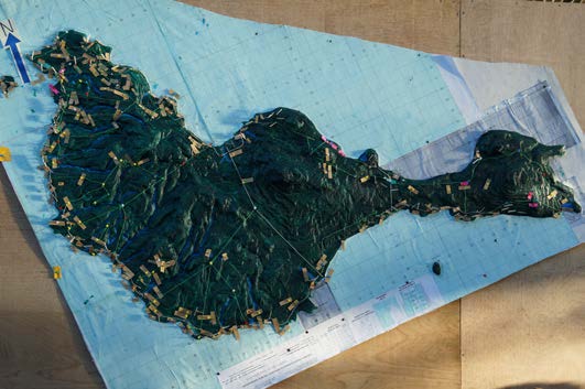
Unlike satellite images or traditional political maps, the maps presented at the conference document key cultural and social sites, such as burial grounds, caches of medicinal plants, hunting trails or groves of specific species of trees. Based on pre-existing maps, satellite images or coordinates generated by hand-held GPS devices, these computer-generated documents or models record knowledge passed down through generations and integrate input from the entire community—including women and youth.

Conference participants heard that indigenous communities have successfully used these maps to protect their lands from land grabs and to monitor the impact of external forces on their lands.

In Brazil, South America’s largest democracy, an Afro-Brazilian community used a map to stop Cyclone-4, a space company jointly owned by Brazil and Ukraine, from expanding into their lands to build rocket launchers. These maps refuted claims by the company that only 10 communities would be impacted by the development by showing that more than 100 communities would be displaced. Cyclone-4’s expansion was blocked—though the government continues its efforts to build the rocket launchers on indigenous territories.

In Panama, which loses one percent of its tropical forests each year, members of the Guna community created a map—in the Guna language—to determine if the expansion of croplands had damaged sacred sites located in the rainforest surrounding their community. The map also served to show younger generations where these sites are located.

In Indonesia, the village of Pandumaan produced hand-drawn maps to scale, based on GPS data, to show that a pulp and paper company encroaching on their lands had razed the forests they rely on for myrrh—a fragrant resin that they sell for a living and use in spiritual rituals.

In Malaysia, which, along with Indonesia, is a leader in palm oil production, communities have used maps to win 25 of the 250 land disputes brought in front of the courts since 2001. The government continues to appeal the 25 cases that it lost in an attempt to regain the lands from indigenous peoples.

40 Million Hectares by 2020

Indonesia’s 2,200 indigenous communities, spread out across the country’s 18,307 islands, are the most prolific indigenous map-makers, the conference revealed. These mapping efforts have added urgency, since the country’s Constitutional Court decided in May that a line in the country’s 1999 Forestry Law, which states that customary forests are state forests, is not constitutional. To take advantage of this decision, which would first have to be implemented in national and local law, experts from the conference said it’s crucial for indigenous peoples to put these forests on paper.

AMAN’s Abdon Nababan said that he hopes to help map all 40 million hectares of land by 2020, and he called on the national Parliament to speed up the adoption of the Law on the Recognition and Protection of the Rights of Indigenous Peoples. The body is currently reviewing a draft of the law.

“Without Indigenous Peoples, There Would Be No Forests”

“Mapping not only empowers indigenous communities with evidence that they can use to assert their land rights, it also provides communities with the ability to catalog the natural resources sheltered in their territories,” said Tauli-Corpuz, the head of Tebtebba. “These maps successfully demonstrate what we already know: that indigenous peoples are the best custodians of their forests and lands.”

A study by The International Union for Conservation of Nature (IUCN) finds that biodiversity thrives in indigenous territories where communities are free to engage in hunting and other sustainable uses of natural resources—as opposed to state-held protected areas that ban such activities.

The National Coalition of Indigenous Peoples (KASAPI) in the Philippines arrived at the same conclusion. The project, which inventoried the resources in indigenous communities across the country, concluded from evidence gathered on the ground and from village elders—who recalled which species of plants have disappeared since their youth—that forests and lands owned and managed by indigenous peoples have stronger biodiversity than those that are under government control.

According to conference participants, maps that document a territory’s biodiversity provide indigenous communities and national governments alike with “baseline” knowledge about the health of their natural resources, enabling them to monitor changes to natural resources, such as the restoration—or degradation—of forests over time. Participants added that maps like these can show the impacts of climate change—and aid in the tracking of global efforts to reduce greenhouse gas emissions.

Vu Thi Hien of the Centre of Research and Development in Upland Areas (CERDA), taught members of the Thai Nguyen community in Vietnam how to map in order to support an international climate change effort to reduce climate change through the protection and preservation of forests, known as REDD+. She said that local authorities were so impressed with the professionalism and accuracy of the maps that they adopted the maps for their own use.

“If the community is not empowered to assert their rights, they can only go so far, even with strong laws supporting land rights,” Tauli-Corpuz said.

###

About Tebtebba
Tebtebba (Indigenous Peoples’ International Centre for Policy Research and Education) is an indigenous peoples’ organization born out of the need for heightened advocacy to have the rights of indigenous peoples respected, protected and fulfilled worldwide. It also advocates and works on the elaboration and operationalization of indigenous peoples’ sustainable, self-determined development. www.tebtebba.org.

About AMAN
AMAN’s mission is to pursue sovereignty, prosperity and dignity of indigenous peoples.  Established on 17 March 1999, its members consist of 2,240 indigenous communities in Indonesia. www.aman.or.id.

Thursday, August 15, 2013

Beneath the Surface ~ Mapping Union Island - A P3DM exercise, 2013


Here is the story of a participatory mapping exercise done on Union Island in St. Vincent and the Grenadines in the Caribbean.

The second of such exercise to be done in the Caribbean under the theme "working with people and nature to find solutions to climate change".

The film gives a glimpse into the, happiness, trials and tribulations of the local people as they participate in a unique participatory mapping process led by Sustainable Grenadines Inc.(SusGren), a local NGO, with support provided by TNC and CTA.

The film also speaks to the local people’s ideas of sustainable development and livelihood opportunities for them and their families.

It also highlights the changes the local community has experienced over the years in their environment and how they have already started to adapt. It certainly takes you in the life of a Unionite and their small island....

midst the challenges of a degrading marine and coastal environment, development pressure from tourism and climate change local people through the mapping process came together with one voice to develop a plan of action for their island future.

Language versions: English | Spanish | French | Portuguese (coming soon)

The film has been produced with funding provided by CTA. Director: Jess Phillimore

Friday, August 09, 2013

Modelagem 3D participativa: Princípios e aplicações de orientação, edição 2010

A modelagem tridimensional participativa (MP3D) é um método de mapeamento participativo que integra conhecimento geográfico nativo com dados sobre elevação do terreno e a profundidade do mar para produzir modelos 3D autônomos, em escala e georreferenciados. Essencialmente com base em memórias, o uso e a cobertura da terram, além de outras características, são descritos no modelo por informantes usando alfinetes para pontos, fios para linhas e tintas para polígonos. Finalmente, uma grade em escala e georreferenciada é aplicada para facilitar a extração ou importação de dados. Os dados descritos no modelo são extraídos, digitalizados e plotados. Após a conclusão do exercício de mapeamento, o modelo permanece com a Comunidade.

A Modelagem Participativa (MP3D) foi concebida como um método para aproximar o potencial do SIG das comunidades rurais e para ultrapassar o fosso que existe entre as tecnologias de informação geográfica e as capacidades encontradas nas comunidades marginalizadas e isoladas, que frequentemente dependem dos recursos naturais.

Este manual se destina a ajudar os ativistas, pesquisadores e praticantes da Aprendizagem e Ação Participativa (AAP) e do SIG a conduzirem a força do SIG até o nível mais básico por meio do uso da MP3D. Ele fornece orientações práticas sobre como organizar e implementar um exercício de MP3D. Além disso, inclui percepções sobre a aprendizagem de adultos e da cognição geográfica, sobre a história dos modelos em relevo e sobre a utilização do método em todo o mundo.

Em 5 de novembro de 2007, Modelagem Tridimensional Participativa (MP3D) foi agraciada com o Prêmio Cúpula Mundial de 2007, na categoria de e-cultura. A MP3D foi considerada como sendo um dos 40 exemplos de boas práticas de qualidade e de conteúdo no mundo.

Por Giacomo Rambaldi
Publicado por: Technical Centre for Agricultural and Rural Cooperation ACP-EU (CTA), julho 2010

Português | English | Francaise | Espanol | Amharic


Monday, August 05, 2013

The Future of PGIS: Learning from Practice? Symposium held at ITC-University of Twente, Netherlands on 26 June 2013

On Wednesday 26 June, 2013 the research group “People, Land and Urban Systems (PLUS)” of the University of Twente organized a full day international meeting on the topic of Participatory Mapping and Participatory GIS (PGIS/PPGIS). The day consisted in a public symposium entitled “PGIS: a toolbox transformed to a practice”, and an Expert meeting to discuss: “PGIS – what next? Preserving the practice in the Geoweb”.

The purpose of the symposium was to reflect on the milestones that PGIS has passed in the last decade bringing it from a mere collection of tools toward a pervasive practice. The expert meeting has been organised to discuss future directions, opportunities and threats for PGIS particularly in light of the growing importance of the Geoweb in spatial information collection and dissemination.

Below are the presentations delivered during the syposium:


Friday, June 14, 2013

Speaking of Home - The Story of the Mount Elgon Ogiek Peoples


The Ogiek peoples live on the slopes of Mount Elgon in Kenya. This documentary shows the Ogiek's relationship to their homeland and to the world.

As indigenous peoples without official minority status in Kenya, the Ogiek have gone through evictions from their native land for decades. Time after another they have returned to their land to continue living in the forest.

The documentary is the Ogiek's story, in their own words, of their hopes before the 2013 Kenyan elections. It was filmed in Chepkitale, Mt. Elgon in 2012 during a mapping workshop.

Through developing a map of their land, the Ogiek not only strengthen their cultural identity, but can show that the land said to belong to someone else, is rightfully theirs.

Credits: The film has been produced by SHALIN Suomi ry and has been featured at the Helsinki African Film Festival

Monday, June 10, 2013

"A contemporary guide to cultural mapping: An ASEAN-Australia perspective" now available!

The cultural mapping process may focus on the past, the present and also the future. Cultural mapping can be used to monitor change in material culture as well as intangible cultural heritage. A cultural map may be created as an end in itself or provide an input into other endeavours.

Many methods and technologies are used to create cultural maps; some are simple and ephemeral such as drawing in the sand. Others use the latest technologies to locate cultural phenomenon spatially using geographic information systems. Whatever methods are used to map culture or cultural products, the map most often takes a physical form (a list, matrix, chart, diagram, design, website, sound recording, video, drawing, painting, textile, sculpture or model) where information is gathered, arranged and presented physically or virtually. In this context the authors use the term map as a mental model and mapping as mental model making as they explore the body of knowledge associated with this expanding field.

The Guide is available free of charge due to the generous support of The Australian National University, the Australian Department of Foreign Affairs and Trade, The National Museum of Australia and The ASEAN Secretariat, Jakarta. It is hoped the Guide will be available online in July/August 2013.

Artlab Australia is co-managing the distribution of hard copies of the Guide. There is a limited print run so if you want a copy we recommend that you place an order immediately. A payment is required to cover the costs of packaging and postage. Postal charges vary enormously depending on destination. To order, please email: artlab@dps.sa.gov.au

For general information about the Guide please contact the authors:

Ian Cook: ianlcook@bigpond.net.au
Ken Taylor: k.taylor@anu.edu.au

Saturday, June 08, 2013

አሳታፊ ሶሰት አምሳያ ቀረጻ፡ መርሆችና አተገባበር (እ.ኤ.አ የ2010 እትም)

አሳታፊ ሶስት አምሳያ ቀረጻ ማለት የአገሬውን ያአካባቢ እውቀት ከዘመናዊ የአካባቢ እውቀት ጋር በማገናኘት ራሳቸውን ችለው የሚቆሙ፣ የተመጠኑና በጂኦግራፊያዊ አቆጣጠር የተስተካከሉ ሞዴሎችን ለመስራት የሚያስችል አሳታፊ የካርታ አሠራር ነው። በአጭሩ በአገሬው የማስታወስ ችሎታ ላይ በመመስረት ፣ የአካባቢ አጠቃቀምና አሰፋፈር እንዲሁም ሌሎች ገጽታዎችን በመረጃ አቅራቢዎች አማካኝነት ሞዴሉ ላይ የተለያዩ መርፌዎችን ለነጥቦች ማመላከቻ፣ ገመዶችን መስመር ለማመላከቻ እና ቀለማቶችን ለስፋት ላላቸው ስፍራዎች ማመላክቻ መጠቀም ማለት ነው። ከዚህም በኋላ መጠኑ የተስተካከለና በጂኦግራፊያዊ አቆጣጠር የተቀመረ ሠንጠረዥ በመጠቀም ከላይ የተጠቀሰው መረጃ ለመለየትና ለማዟዟር በሚያመች መልኩ ይቀመጣል። በተራው ይህ ተለይቶ የወጣው መረጃ ይነጠልና በኮምፒዩተር ለማንበብ አመቺ እንዲሆንና ለመጠናዊ አገማመት አመቺ እንዲሆን ተደርጎ ይቀመጣል። በዚህ መልኩ የተጠናቀቀው ሞዴል በዛው በአገሬው ዘንድ ተቀማጭ ይደረግል።
አሳታፊ ሶስት አምሳያ ቀረጻ የተጸነሰው ዘመናዊውን ጂ.አይ.ኤስ. ቴክኖሎጂ በገጠር ለሚኖሩ ሕዝቦች በሚስማማ መልኩ በማቅረብ በዘመናዊ የጂ.አይ.ኤስ ቴክኖሎጂና በተፈጥሮ ሃብት ላይ ኑሯቸውን መሰረት ባደረጉና የገጠር ኅብረተሰቦች መካከል ያለውን የአቅም ልዩነት ለማጥበበ ነው።
የዚህ ማስተማሪያ ዓላማም ለጂ.አይ.ኤስና አሳታፊ ማስተማሪያ መንገዶች ተመራማሪዎችና ባለሙያዎች ጂ.አይ.ኤስን ባለሙያ ላልሆኑና ታች ላሉ ህብረተሰቦች አሳታፊ ሶስት አምሳያ ቀረጻን በመጠቀም ማዳራስ እንዲችሉ ነው። አንድ አሳታፊ የሶስት አምሳያ ቀረጻ ዝግጅትን ከመጀመሪያ እስክ መጨረሻ ለማዘጋጀት የሚያስችል ምክሮችን ደረጃ በደረጃ ያስቀምጣል። በተጨማሪም ይህንን የማስተማሪያ ዘዴ ከዚህ በፊት በተጠቀሙ ከዓለም ዙሪያ በተውጣጡ ባለሙያዎች አዋቂዎችን ስለማስተማርና ይህንን አሳታፊ መንገድ ስለመጠቀም የሰጡትን አስተያየት ያካትታል።
እ.ኤ.አ. ኅዳር 5 ቀን 2007 ዓ.ም.፣ አሳታፊ የሶስት አምሳያ ቀረጻ የአለም ጉባዔ ሽልማትን  በኤሌክትሮኒክ- ባህል ደረጃ አግኝቷል። በሌላም በኩል አሳታፊ ሶስት አምሳያ ቀረጻ በአለም ከሚገኙ ተመሳሳይ መንገዶች ከምርጥ አርባዎቹ ውስጥ ተካቷል።

Download the Amharic version of the P3DM handbook (New!)
English version | French version | Spanish version 
Portuguese version: forthcoming!

Thursday, May 23, 2013

Community mapping video documentary


This video documents community mapping activities in Myanmar, Nepal and Thailand.

In memory of Perween Rahman (1957-13 March 2013), a Pakistani social activist, director of the Orangi Pilot Project Research and Training Institute. She was murdered on 13 March 2013.

Read more
Pakistan mourns murdered aid worker Perween Rahman (BBC)

Friday, March 29, 2013

Traditionally Occupied Lands in Brazil

For several decades, social groups that were once “invisible” in Brazil have formed movements based on collective identities closely tied to natural resources use in specific territories. Their mobilization is a response to illegal land speculation, rural violence, and resource degradation associated with the expansion of agro-business, mining, and other activities that threaten many of the natural resources and collective-use territories upon which these groups have long inhabited. In spite of changes in Brazilian legislation that facilitate the recognition of land use based on collective identities – the Brazilian Federal Constitution of 1988 recognizes the rights of quilombolas, indigenous people, and other “traditional” populations – many groups throughout the country continue to struggle to obtain formal recognition of their lands and the resources they depend upon for survival.

Based on more than thirty years of research focusing on social movement mobilization and land issues throughout Brazil, Alfredo Wagner Berno de Almeida’s book Traditionally Occupied Lands in Brazil analyses the relationship between the rise of social movements based on collective identities and the “traditionally occupied lands” that many of these groups are struggling to defend, maintain, and recover.

As a point of departure for understanding resource conflict, this text presents a detailed analysis of the divergence between the official land use and property rights legislation in Brazil and the land use and cultural practices of various social groups struggling to maintain their “traditionally occupied lands” and associated cultural practices. By comparing and contrasting how natural resources are used, owned, and appropriated in Brazil, this book provides a unique vision of the connections between shared identities, social movement formation, land use practices, and natural resource conflict.

Author: Alfredo Wagner Berno de Almeida
ISBN: 978-85-7883-149-3
Publisher: PGSCA-UFAM, Manaus, 2011


Oil palm expansion in the Philippines: geo-tagged evidences of an imminent tragedy

By ALDAW Network (Ancestral Land/Domain Watch): Between June and August 2009, an ALDAW mission travelled to the Municipalities of Brooke’s Point and Sofronio Española (Province of Palawan) to carry out field reconnaissance and audio-visual documentation on the social and ecological impact of oil palm (Elaeis guineensis) plantations.  The mission’s primary task focused on two major objectives: 1) gathering data through interviews, ocular inspection and participatory geographic information systems methodologies; 2) providing communities with detailed information on the ecological and social impact of oil palm plantations, to allow them to make informed decisions while confronting oil palm companies, state laws and bureaucracy.

Successive ALDAW field appraisals in oil palm impacted areas took place between July 2010 and early 2013, and included the Municipalities of Aborlan, Rizal and Quezon. During ALDAW field research, GPS coordinates were obtained through the use of a professional device connected to the camera’s hot shoe.  

The geotagged images have been loaded into a geo-aware application and displayed on satellite Google map. The actual ‘matching’ of GPS data to photographs has revealed that, in specific locations, oil palm plantations are expanding at the expenses of primary and secondary forest and are competing with pre-existing cultivations (coconut groves, fruit tress, wet-rice, etc).

The conversion of productive paddy land and forest into oil palm plantations is particularly evident in the Municipality of Quezon .

Oil palm plantations have also expanded in areas used by indigenous people for the cultivation of local varieties of upland rice, root crops and fruit trees.  Furthermore, the fencing of large areas of oil palm plantations makes it difficult for local communities to reach their upland fields and forest.

Geottaged evidences have also revealed the exact location of commonly used NTFPs, such as buri palms (Corypa elata) and bamboos that are being destroyed through massive land clearing by oil palm companies.

Moreover, geocoded photos have provided indications on the location of rivers and freshwater sources that are being incorporated into oil palm plantations and that are likely to become polluted through the use of pesticides and fertilizers.

These freshwater sources provide potable water for local communities and some of them are essential for the maintenance of community-based dams.

Initial steps are now being taken to establish collaborative exchanges between the oil palm impacted indigenous communities of Palawan and those of Mindanao which are facing a similar fate.  These exchanges and cross-visits will include training courses on geotagging and participatory videos done by indigenous peoples (ALDAW staff) to other indigenous groups such as the Higaonon of Bukidnon.  In addition to this, during such cross-visits, common advocacy strategies to resist oil palm expansion nationwide will be identified.

In response to recent research findings, see Palawan Oil Palm Geotagged Report 2013 (Part 1 and Part 2)

ALDAW has launched two major campaign initiatives:
  • Petition 1 (covers Palawan and Mindanao, addressed to the National Government) 
  • Petition 2 (covers Palawan specifically, addressed towards the Provincial Government, the Palawan Council for Sustainable Development (PCSD) and the National Commission on Indigenous Peoples (NCIP)
Oil palm expansion on indigenous land both in Palawan and Mindanao should be stopped with haste, before its adverse socio-ecological impact becomes irreversible. Please, give your contribution by signing the above petitions.

Friday, March 15, 2013

Local voices in climate change adaptation - Union Island, Caribbean - Trailer


As a follow-up to the introduction of Participatory 3D Modelling (P3DM) in the Caribbean which took place in Tobago in October 2012, the NGO SusGren replicated the process in Union Island (St. Vincent and the Grenadines, Caribbean) in the context of the "At Waters Edge: Coastal Resilience in Grenada and St. Vincent and the Grenadines (AWE)" project.

Project implementation has been supported by the Nature Conservancy (TNC) and the Technical Centre for Agricultural and Rural Cooperation ACP-EU (CTA).

Here is a short trailer on the video production which will be launched at the Caribbean Week of Agriculture in October 2013.

Wednesday, February 13, 2013

Who Counts? The Power of Participatory Statistics

Local people can generate their own numbers – and the statistics that result are powerful for themselves and can influence policy. Since the early 1990s there has been a quiet tide of innovation in generating statistics using participatory methods. Development practitioners are supporting and facilitating participatory statistics from community-level planning right up to sector and national-level policy processes. Statistics are being generated in the design, monitoring and evaluation, and impact assessment of development interventions. Through chapters describing policy, programme and project research, Who Counts? provides impetus for a step change in the adoption and main-streaming of participatory statistics within international development practice.

The challenge laid down is to foster institutional change on the back of the methodological breakthroughs and philosophical commitment described in this book. The prize is a win–win outcome in which statistics are a part of an empowering process for local people and part of a real-time information flow for those aid agencies and government departments willing to generate statistics in new ways. Essential reading for researchers and students of international development as well as policy-makers, managers and practitioners in development agencies.

'This is a timely compilation of ground-breaking work which adds up to a powerful agenda for transformation. This book shows how we can quantify the qualitative, build the active agency of excluded groups and generate participatory statistics that have greater rigour and legitimacy than most conventional statistics.’ David Archer, Head of Programmes, ActionAid


Who Counts?
Edited by Jeremy Holland with an Afterword by Robert Chambers
Practical Action Publishing