Map symbols should be designed or chosen according to principles of logic and communication to serve as a graphic code for storing and retrieving data in a two or three dimensional geographic framework.
Appreciating the logic of map symbols begins with understanding the existence of three distinct categories, including point, line and polygons (areas).
Maps and 3D models include generally a combination of all three. These tree main categories can be further differentiated by variations in "hue" (color), "gray tone value", "texture" and "orientation", "shape" and "size".
Each of these variables or their combinations excel in portraying particular features and their variations.
When using color (hue) for characterizing areas, decoding is made simpler when darker means "more" and lighter means "less". Color conventions allow map symbols to exploit idealized associations of water with blue and forested areas with green. This the combination of the two, implies that dense primary forest is dark green, secondary forest green, and grassland light green, and that deep waters are dark blue and shallow waters light blue .
"Size" is more suited to for showing different in amount of count, whereas "variations in gray tone" are preferred for distinguishing differences in rate or intensity. Symbols varying in orientation are useful mostly for representing directional occurrences like winds, migration streams or other. Line symbols best portray water courses, roads, trails, boundaries and may combine different variables, including color and size (thickness). A heavier line readily suggests greater capacity or heavier traffic than a thin line implies.
Each symbol should be easily discernable from all others to clearly distinguish unlike features and provide a sense of graphic hierarchy. A poor match between the data and the visual variables may frustrate and confuse the map user.
While in planimetric mapmaking the only limitation in the choice of symbols is fantasy (with logic), participatory 3-D modeling (P3DM) frequently depends on the availability of materials, particularly for point features which are generally represented by push and map pins. Lines and polygons can be easily represented by color-coded yarns and different color paints.
Standardization of symbols serves for ready unambiguous recognition of features and promotes efficiency in both map production and use, exchange of data and comparison. Maps and models sharing a common graphic vocabulary are definitely more powerful in convening the intended message and decoding simpler.
Pages
▼
Saturday, June 20, 2009
Wednesday, June 17, 2009
P3DM after the 2007 World Summit Award
In November 2007 "Participatory 3D Modelling (P3DM) for Resource Use, Development Planning and Safeguarding Intangible Cultural Heritage in Fiji" was proclaimed as one of the four winners of the “Worlds Best e-Content 2007” in the World Summit Award category e-Culture.
Here is an account of what has happened since the exercise was carried out in Fiji.
Since 2005 (year in which the project in Fiji was implemented) Participatory 3D Modelling (P3DM) and been adopted in development contexts in many parts of the world (http://www.p3dm.org/) including Cambodia, Colombia, East Timor, Ethiopia, France, Guyana, Italy, Kenya, Malaysia, Nepal, PNG, Australia and other countries.
The 2007 WSA recognition added value and authority to the method and gave worldwide recognition to its quality and appropriateness.
In Kenya P3DM been used by Ogiek, Yiaku and Sengwer Indigenous Peoples to document their biophysical and cultural landscapes. The objectives of these community-led interventions included enhancing inter-generational information exchange, adding value and authority to local knowledge, improving communication with mainstream society, improving planning on sustainable management of natural resources and addressing territorial disputes.
In Ethiopia P3DM has been used to assist stakeholders in the Bale region to plan out sustainable management of the area, revive their bio-cultural diversity and support local environmental education.
The Indigenous Peoples of Africa Coordinating Committee (IPACC), a pan-African network of 150 organisations adopted the method and is spearheading its adoption in the African Continent to improve awareness at policy-making level on the relevance of location-specific traditional ecological knowledge (TEK) in climate change adaptation and mitigation processes. Read more.
UNESCO has been supporting the adoption of P3DM in Niger and Kenya in the context of the of the Convention for the Safeguarding of the Intangible Cultural Heritage paying specific attention on the opportunity for safeguarding traditional ecological knowledge as part of overall intangible cultural heritage and its integration into the education curricula.
In collaboration with national and regional partner organisations, the Technical Centre for Agricultural and Rural Cooperation EU-ACP (CTA) is supporting the dissemination and adoption of P3DM practice in ACP countries. Regional capacity building exercises are scheduled in Central Africa (Gabon and DCR), West Africa (Niger) and Southern Africa (Botswana) in 2010 and 2011.
In collaboration with a number of development agencies, CTA is spearheading the production of a training kit supporting the spread of good practice in generating, managing, analysing and communicating spatial information. The kit includes a module on participatory 3D Modelling.
Other initiatives include the ongoing online participatory translation of a video documentary on P3DM “Giving the Voice to the Unspoken” using the free platform http://dotsub.com/
Thursday, June 11, 2009
Sculpture and Science help in Planning to Preserve The Mutton Hole Wetlands in Australia
A 3D model of the Mutton Hole Wetlands near Normanton has been developed as a starting point for community consultation and discussion about how best to preserve and use the Mutton Hole Wetlands.
The Mutton Hole Wetlands are situated just to the North and West of Normanton, and are a part of the Southern Gulf Aggregation, the largest continuous wetland of its type in northern Australia. Being vital for bird migration routes across northern Australia, the Southern Gulf Aggregation is considered to be of state, national and international significance.
In the past the wetlands formed part of the neighbouring Mutton Hole cattle station, but the area was declared a Conservation Park in 2004. Currently managed by Queensland Parks and Wildlife, Carpentaria Shire Council has been considering managing the park themselves. As a part of this consideration the Northern Gulf Resource Management Group has gained funding to write a management plan for the wetland.
The management plan will highlight Aboriginal culture as well as the environmental values of the wetland in a plan to conserve it for future generations. There is strong support from the scientific and local community for use of the wetlands for bird watching, teaching and eco-tourism. As a step towards greater community consultation a model of the wetland area was built and is now located in the Normanton Visitor Information Centre (Burns Philp Building).
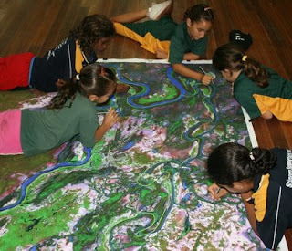
Over six weeks in April and May 2009 students and staff from Normanton State School and the Gulf Christian College worked together with Dr Isla Grundy of CSIRO to construct a 3D model of the Mutton Hole Wetlands, using a technique called Participatory 3D Modelling (P3DM).
The model was made by first tracing the image of the wetlands from a 1:9500 satellite image onto a large piece of cardboard, then other features were added on or cut out. Finally, the rest of the landscape was painted onto the cardboard and the boundary of the Conservation Park marked with thread.
P3DM is a relatively new technique developed in the Philippines to support collaborative resource use and management, aimed to facilitate community participation in problem analysis and decision-making. This is the first time this participatory technique has been used to make a landscape model from cardboard in Australia.
Since mid-May 2009 the model has been displayed at the Normanton Visitors Information Centre and on Thursday 21st May there was a formal public opening when students, parents and interested community members came to see what the schools had been working on. The exhibition was opened by Vicki Jones of Northern Gulf, along with Isla Grundy of CSIRO and Agnes Hughes from Normanton State School. The forty or so people who attended were able to take a closer look at the model and discuss wetland history and potential use. The community at large was invited to give it’s opinions and ideas on how the Mutton Hole Wetlands should be managed and used in the future through individual community consultations and group discussions held at the Information Centre.
Source:
Dr Isla Grundy
Community Agro-Ecologist CSIRO Sustainable Ecosystems,
JCU / CSIRO Tropical Landscapes Joint Venture
Australian Tropical Forest Institute, James Cook University, Cairns, QLD 4870
Community Agro-Ecologist CSIRO Sustainable Ecosystems,
JCU / CSIRO Tropical Landscapes Joint Venture
Australian Tropical Forest Institute, James Cook University, Cairns, QLD 4870