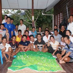
 Community members and park naturalists have completed a participatory 3-dimensional scaled model of the Buayan-Kionop area showing areas important for community livelihoods. The pproject, funded by the Darwin Initiative, is designed to contribute to the nomination of the Crocker Range Biosphere Reserve. Work began in August 2009 with local partners and 10 indigenous communities. Local researchers from Buayan-Kionop are sharing their skills with neighbouring communities to document and map community livelihood patterns for the entire Ulu Papar area. They have been using a range of techniques, including participatory GIS and participatory 3-dimensional modelling (P3DM) to show areas important for cultivation, hunting, fishing and gathering of forest products. Over the next 3 years, we will build on the participatory research results in Buayan-Kionop and create spaces for community dialogue on balancing conservation and sustainable resource use in the Crocker Range.
More information on the programme is found here.
Source: Agnes Lee Agama, Southeast Asia coordinator, Global Diversity Foundation update December 2009

1 comment:
Mapping was quite interesting, which is useful for GIS study.
Nice blog. Thanks for sharing..
regards
gis companies
Post a Comment