Showing posts with label conservation. Show all posts

Monday, August 22, 2016

#12614 – Book Launch and Reception for ‘The power of maps: Bringing the third dimension to the negotiation table’, a CTA Success Stories publication on participatory GIS practice


IUCN World Conservation Congress 2016, Hawai’i, USA, 
Friday, 2 September 2016, 19:30-21:00
Room 314-UNDP Kauhale

Abstract of the session (including reception, drinks and snacks)


This session will see the launch of a collection of 12 impact stories about participatory 3-dimensional modelling (P3DM) – an innovative process that maps traditional knowledge as physical three-dimensional models. P3DM enables marginalised communities to present their territory – together with their own valuable knowledge – in a physical and visual form, offering an opportunity to monitor precious resources against outside threats and preserve them for future generations. It helps to foster sustainable natural resource management, gives a voice to grassroots communities and helps them to influence policy-making and make informed decisions on climate change adaptation. The Power of Maps: Bringing the third dimension to the negotiation table is published by the Technical Centre for Agricultural and Rural Cooperation (CTA), which has been in the forefront of activities to promote the practice across African, Caribbean and Pacific (ACP) countries.

Speakers include those who narrated stories captured in the book and others who have been practicing P3DM across several continents and for diverse purposes.

Objectives of the event

  1. To launch a new CTA publication which is part of the ‘Success stories’ series
  2. To demonstrate the value of participatory mapping in three dimensions and its impact on identity building, informed spatial planning and community engagement
  3. To discuss how best to further upscale the deployment of the process in community-based initiatives

Format and Programme 

The general format of the workshop will be as follows (total time: 90 min):
  • Opening, introduction of speakers and key questions to be addressed (5 minutes)
  • Video address by CTA (3 min)
  • First set of two presentations (7-10 minutes each) (20 minutes)
  • Questions and answers, followed by discussion related to the first set of presentations (15 minutes)
  • Second set of two presentations (7-10 minutes each) (20 minutes)
  • Questions and answers, followed by discussion related to the second set of presentations and for general discussion as well.  (20 minutes)
  • Closing comments (5 min) 

Detailed programme:

19:30-onwards: Reception, serving of snacks and drinks

19:35-19:40 Opening, introduction of speakers and key questions to be addressed Dialogue moderator: Hindou Ibrahim, IPACC West Africa Coordinator

19:40-19:45 Address and introduction of the publication (video link); Giacomo Rambaldi, CTA Senior programme coordinator

19:45-20:05 First set of two presentations:
Senoveva Mauli, Solomon Islands Community Conservation Partnership (SICCP), Solomon Islands
Ana Fekau, Min of Environment in Tonga

20:05-20:20 Q&A and discussion (on first set of presentations)

20:20-20:40 Second set of two presentations
Nigel Crawhall, IPACC, South Africa
M’Lis Flynn, Wet Tropics Management Authority (on private capacity), Australia

20:40-20:55 Q&A and discussion (on second set of questions) Time allowed for general discussion as well.

20:55-21:00 Closing comments and distribution of copies of the publication to participants: Nigel Crawhall, IPACC, South Africa

Download programme


Sunday, October 07, 2012

Participatory 3D Models Helping PNG Communities in Natural Resource Decision-Making


Patrick Vuet from a Papua New Guinean conservation NGO 'Partners with Melanesians', has involvement in a participatory method of planning in Melanesia - Participatory 3 Dimensional Modelling. All members of the community are involved -men and women, young and old. Through a 3 dimensional model they can easily see their landscapes and use the model to visualise impacts of certain developments such as mining. In PNG the government doesn't believe the local communities have the capacity to make decisions, but having a 3D model changes everything

Wednesday, March 24, 2010

Power of Maps: (Counter) Mapping for Conservation

This paper considers what is at stake in defining and mapping protected areas for conservation. The authors link issues of power in cartography to themes from political ecology, social natures, and conservation biology literatures to extend our understanding of maps as reflective of, and productive of, power. Reviewing insights from these literatures to consider power asymmetries common to conservation practice, they highlight ways that mapping practices and products reinforce and contribute to such dynamics.

The authors argue that in doing so enriches consideration of the power geometries of conservation cartographies by inviting fuller consideration of diverse species and landscapes, as well as enabling discussion of other representational and productive effects of conservation mappings. Once determined, how might conservation maps serve to naturalize certain spaces or boundaries as fixed, or contribute to certain socio-psychological understandings of conservation possibilities or outcomes?

In the closing sections, the authors invoke the idea of ‘counter-mapping’ to explore strategies that might redress these concerns. Possibilities range from efforts to adapt the form of protected areas to more critical approaches that question the appropriateness of territorial focus and mapping practices for conservation goals.

In conclusion, Harris and Hazen argue that theorizing power in human, other-than-human, and inter-species contexts is essential to understanding the power geometries of conservation mapping.

Citation: Leila M. Harris and Helen D. Hazen, 2006. Power of Maps: (Counter) Mapping for Conservation. ACME: An International E-Journal for Critical Geographies, 4 (1), 99-130

Thursday, January 21, 2010

The Bulanjao Geotagged Report

On August 2009, a mission led by the Philippines-based Ancestral Land/Domain Watch (ALDAW) and the Centre for Biocultural Diversity (CBCD) at the University of Kent traveled to Barangay Sumbiling, Municipality of Bataraza, Province of Palawan (Philippines).

Geo-referenced audio-visual and photographic documentation was carried out in the Bulanjao range whose vegetation consists of a very unique type of forest growing on ultramafic /heavy-metal rich soils. The area is home to at least four plant species that are classified as vulnerable and two of them have already been included in the IUCN Red List.

In spite of its unique ecological features, the Bulanjao range has been subjected to mineral exploration and development by the Rio Tuba Nickel Mining Corporation (RTNMC). RTNMC is a Filipino-Japanese partnership holding a mining concession area of about 5,265 hectares.

RTNMC and its partner, Coral Bay Nickel Corporation (CBNC), need to mine nickel ores as part of the expansion of their new Hydrometallurgical Processing Plant (HPP) project. However, one the conditions specified in the Environmental Compliance Certificate (ECC) issued to them in 2002, is that “core zones” - as identified by the Strategic Environmental Plan for Palawan (Republic Act Republic Act 7611) should not be included in the areas of mining operations and, this, of course includes the Bulanjao range.

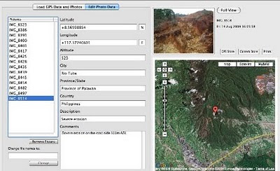
Starting at an elevation of about 40m ASL, the ALDAW/CBCD mission followed the mining road to reach the highest portions of the Bulanjao range. Geo-tagging evidence indicates that erosion on the Bulanjao mining road is occurring also at low elevations. During the rainy season the water creates deep clefts on the roadsides, hence penetrating the soil and fostering road collapse. No mitigating measures have been put into place to reduce erosion. A huge crater-like excavation has been found at 566m ASL. and land slides, induced by road construction, have been documented around the sources of the Sumbiling river, at almost 900m ASL. The latter is the most important water source for both lowland farmers and indigenous communities.

Marylin Samparan, a local IP living in the area told the mission: “time will come when our children will no longer recognize the names of trees, the footprints of animals, the birds’ songs. This will be the time when the forest will be gone, the mining companies will be gone, the rivers will no longer flow…and us? We will still be here”.

On 15 August 2009, the mission established that mining road had already reached an altitude of 859m ASL – and its exact location was defined through the following GPS coordinates (+ 8.59322548 N Latitude and + 117.36516571 E Longitude).

Mission’s findings have now been compiled into a geo-tagged report, which is being used by local indigenous communities to support their legal struggle against mining in Bulanjao.

Source: The ALDAW NETWORK

The ALDAW NETWORK (Ancestral Land/Domain Watch) is an advocacy-campaign network of Indigenous Peoples jointly constituted by NATRIPAL (United Tribes of Palawan) and BANGSA PALAWAN PHILIPPINES (Indigenous Alliance for Equity and Wellbeing) on August 2009.

Wednesday, September 09, 2009

Participatory 3D Model (P3DM) of Chivoko village, Solomon Islands

A total of 60 representatives from the Chivoko community including youth, elders, women and men, students and chiefs; representatives from "Sasamunga Live and Learn", The Nature Conservancy (TNC), the "Lauru Land Conference of Tribal Communities" (LLCTC), and the Choiseul Provincial Fisheries constructed a 1:20,000 scale Participatory 3D Model (P3DM) of Chivoko village in the Tavula ward, Choiseul Province, Solomon Islands. The model covering a total area of 192 sq km is the 1st if its kind in Solomon Islands.

The model has been done to serve a key negotiation tool for the Chivoko community to map out the watershed and coastal areas it depends on to address the challenges facing sustainable resource management and conservation. The initiative aims at securing the conservation of the Chivoko Watershed forests (approx 8000 ha) and place them legally beyond the reach of industrial logging ventures. The project will draw on national expertise to produce a collaborative watershed management plan which will provide guidance for sustainable forest development practices by a community cooperative.

More information is found here.