Showing posts with label web2fordev. Show all posts

Thursday, September 10, 2015

The Transformative Power of Social Media in Agriculture: Inspiring Stories

The advent of social media has revolutionised the way people communicate worldwide. But in a growing number of developing countries, these tools are being put to increasingly good effect to drive agricultural and rural development, often with dramatic results. A new publication from the Technical Centre for Agricultural and Rural Cooperation (CTA) documents the transformative power of these innovative technologies. Based on 18 case studies drawn from across African, Caribbean and Pacific (ACP) countries , Embracing Web 2.0 and Social Media: A life-changing pathway for agricultural development actors provides testimonies on how Web 2.0 and social media are contributing to better engagement of stakeholders in policy dialogue and advocacy, marketing and the provision of information services.

The booklet documents a wide range of practical applications for Web 2.0 and social media in ACP settings. Some farmers have found that Facebook can be an excellent marketing channel to promote their products. Extension agents are discovering that social media is a highly effective way of communicating with the people they serve. Agricultural organisations are using a range of social media tools to mount advocacy campaigns aimed at influencing policy-makers. Researchers are using online collaboration tools to work on joint publications, while more and more young people are using new ICT skills to blog about important rural development issues. Others are seizing opportunities to develop innovative online services and launch their own companies as agripreneurs.

“Social media has become part of everyday life for most people in the developed world. But it has created a life-changing experience for many people in rural areas who have come to use it,” said CTA Director Michael Hailu.

All the stories featured in the booklet revolve around people who have benefited from a CTA-led campaign to make Web 2.0 and social media tools more accessible to agriculture and rural development actors in ACP countries.

The figures speak volumes: more than 4,000 individuals trained, 176 face-to-face training events – known as Web 2.0 and social media learning opportunities (LOs) – held in 44 ACP countries. In 2013, the Web 2.0 and social media LOs carried off the prestigious World Summit on the Information Society (WSIS) Project Prize in the e-Agriculture category.

Impact assessment studies conducted by CTA have revealed that its Web 2.0 and social media capacity-building activities have led to greater inclusion and empowerment for participants, often with far-reaching repercussions for themselves and the people with whom they interact. Adoption rates are high, with young women emerging as the most likely players to adopt social media, following a training course.

In Uganda, local NGOs are using ICTs to support producers, processors and other actors in agricultural value chains. Agronomists from Madagascar are using Web 2.0 and social media to develop knowledge about apiculture. In Central Africa, a farmers’ network institutionalised social media and improved its operational effectiveness. In Samoa, a Facebook and Twitter marketing campaign is producing impressive results for women weavers of ceremonial mats. And in the Caribbean, bloggers and social media reporters are helping other young people to plan a future in farming.

“Many people have told us that the training sessions have not only changed their working behaviour, but their whole lives,” said Giacomo Rambaldi, Senior Programme Coordinator at CTA.

The official launch of the CTA publication will be held on 26 November 2015 during the International Day of Vrije University (VU) in Amsterdam.

The booklet is available for order in print form or for free download from the CTA publications catalogue

Saturday, September 01, 2012

Tobagonians will build a participatory 3D model of Tobago to plan for impacts of climate change and extreme climatic events


Over 200 residents of Tobago will come together in early October 2012 to build a three-dimensional model of Tobago. The process will contribute to formulating responses and develop action plans addressing the impacts of climate change and extreme climatic events.

The process will be facilitated by the Caribbean Natural Resources Institute (CANARI), the University of the West Indies (UWI), the Tobago House of Assembly (THA), Division of Agriculture, Marine Affairs, Marketing and the Environment (DAME) and the Partners with Melanesians (PwM).  The project is funded by the Technical Centre for Agricultural and Rural Cooperation ACP-EU (CTA) and the United Nations Development Programme and the Global Environment Facility (GEF) Small Grants Programme (SGP).

The project will pilot, for the first time in the region, the use of participatory three-dimensional modelling (P3DM).  P3DM is a tool that can be used across the Caribbean islands to facilitate effective participation by local communities and other stakeholders in the identification of general policy priorities, as well as specific policies and actions needed on the ground  to address the impacts of climate change and extreme climatic events.  P3DM will allow the recognition of the value of traditional knowledge, increase capacity, facilitate coordination and collaboration across sectors, and build buy-in for implementation of plans for resilience to climate change and extreme climatic events.

In this regard, 15 trainees from the Caribbean region (including five from Tobago) will be trained to facilitate the building of the model. Nearly 50 observers from the region will visit during the construction of the model.  Lessons learned and experiences will be documented and shared using a variety of media including participatory video, blogs and policy briefs.

P3DM produced in Boe BoeSolomon Islands
Image courtesy of Javier Leon, University of Wollongong
The physical output of the workshop will consist in a 1:10,000-scale 3D model of the entire island of Tobago and its surrounding waters up to a depth of -100 meters. The model will cover an area of approximately 1,152 km2.


Once the model will be completed island'a representatives will produce a civil society agenda to tackle among others climate change issues in the island.  This activity consisting in a 3-day workshop will be facilitated by CANARI, through the support of grant funding from the Federal Republic of Germany.

CTA will further provide capacity building in the domains of Web 2.0 and Social Media to enhance Information, Communication and Knowledge Management (ICKM) among local stakeholders. 

On 5 and 6 September 2012, UWI, DAME and CANARI will host mobilisation meetings in east and south-west Tobago to sensitise the residents in Tobago about the project and to confirm participation of civil society groups in the exercise.

For further information, please contact: Neila Bobb-Prescott - Manager, Forest, Livelihoods and Governance Programme, Caribbean Natural Resources Institute.


Note: The initiative is supported by CTA in the context of the project "Promoting participatory ICTs for adding value to traditional knowledge in climate change adaptation, advocacy and policy processes in the Caribbean and the Pacific". For information on this project you may contact Giacomo Rambaldi, Sr. Programme Coordinator, ICT4D, CTA


Video collection of P3DM initiatives: http://vimeo.com/channels/pgis
P3DM worldwide: www.p3dm.org

Saturday, May 21, 2011

Changing the World, One Map at a Time


The Ushahidi platform is built on the Kohana web framework, a fork of the CodeIgniter framework. It includes built-in support for Clickatell SMS gateways, and the official Ushahidi-hosted websites use the commercial service. Ushahidi provides the option of using OpenStreetMap maps in its user interface, but requires the Google Maps API for geocoding. Ushahidi is often set up using a local SMS gateway created by a local FrontlineSMS set-up. This video provides a good overview on how the platform is being used around the world.

Source: Wikipedia

Thursday, February 24, 2011

The ALDAW Save Palawan Campaign: using web 2.0 for policy Advocacy on indigenous peoples

In March 2006, former Philippine President Gloria Macapagal-Arroyo called for a revitalization of mining nation-wide. Open-pit and strip mining for nickel results in the flattening of mountain tops, in the plundering of forest and in the production of vast amounts of tailings that contaminate freshwater sources and the sea. Palawan, the richest Philippines’ province in terms of biocultural diversity, and a UNESCO Man & Biosphere Reserve, is threatened as ever before.
ALDAW (Ancestral Land/Domain Watch), a local advocacy network decided to take immediate action, in the attempt of bringing the plight of Palawan indigenous peoples to international attention. In 2009, ALDAW in collaboration with the Centre for Biocultural Diversity (CBCD) of the University of Kent, began to produce participatory videos amongst indigenous communities. The primary aim was to provide communities with more information on the ecological and social impact of mining, in order to allow people to make informed decisions while confronting mining corporations. ALDAW began its journey amongst those communities who had already experienced the effects of mining. The recorded testimonials from community representatives (both indigenous and migrant farmers) were shared with other communities who were still in the process of confronting mining companies, and were unsure about the way in which they should approach these enterprises. These videos have had a tremendous impact in terms of bringing local grass-root voices to policymakers and to the global level. 
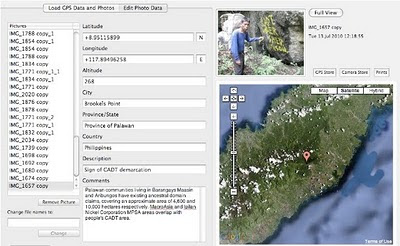
Dedicated ALDAW channels on YouTube and a page on Vimeo were established. For the residents of Palawan, these platforms have become an essential channel for presenting their claims and aspirations, as well as for entering into a dialogue with other indigenous communities from around the globe. ALDAW fieldwork also included the production of geo-tagged images aimed at documenting the overlapping between mining concessions, fragile environments and the ancestral territory of indigenous communities. Geo-tagged photos were loaded into a geo-aware application, displayed on satellite Google map and posted on the ALDAW Facebook Page. ALDAW also posted an Online Petition that, as of the present, has been signed by almost 4,900 people, while ad additional 20,000 signatures were collected through the assistance of Rainforest Rescue. 
Networking and the wide dissemination of information on the Palawan case encouraged other organizations - such as Survival International - to support the ALDAW campaign. As of now, a number of advocacy organizations and research institutions provided added channels for ALDAW to disseminate information including video documentaries (vlogging) and updates from the field. See, for instance, Intercontinental Cry, PPgis.Net Blog , Plant Talk of the Eden Project, Community Solidarity Response Toronto, CEESP, the IUCN Commission on Environmental, Economic and Social Policy, PipLinks (Philippine Indigenous Peoples Links). 
Rainforest Rescue also decided to support ALDAW struggle, by petitioning the UNESCO for taking no action to protect its declared Palawan Man & Biosphere Reserve. As a result of this action, ALDAW has been approached by the UNESCO and preliminary negotiations are ongoing. 
Just when the Palawan campaign almost appeared to have reached its peak, a tragic and unexpected event took place in Palawan on 24 January 2011, Gerry Ortega, an environmental advocate and broadcast journalist, was killed by a gunman after finishing his daily radio program on DWAR Palawan, which had been very critical of mining interests. Right after this, the ABS-CBN Foundation of the Philippine decided to fully support anti-mining efforts in Palawan, through the lunch of a 10 Million Signatures “No to Mining in Palawanonline petition. 
Recently, in response to the mounting outcry from both International and National communities, Pres. Benigno Aquino III announced that the government will cancel more than 300 pending mining applications in Palawan. ALDAW and the NGO community have welcomed the President’s decision, but they also warned that this will have little impact on the ecological integrity of Palawan because it would not stop the destruction and degradation being done by those mining projects that are already operating on the island.
People interested in the topics can join this GoogleGroup.
Impact on policy making:
Here are some articles appeared in the press:
Comments are reflections
The short article summarizes the experience and methodologies of the ALDAW Network in bringing the voices of mining affected communities on Palawan Island (the Philippines) to national and international attention.  The overall ALDAW campaign strategy combines community grounded work with several WEB 2.0 tools/platforms such as YouTube, Vimeo, Blogs, Vlogs, Facebook, Geotagging, GoogleGroups, e-networking, and other tools for monitoring the occurrence of selected topics on the net, etc.
Some of the key lessons learned which ALDAW could share with other indigenous/farmers groups, as well with NGOs and People’s Organizations from different countries include the following:
  1. How to use participatory videos to fostering reflection and joint actions while establishing strategic grass-root alliances against extractive-industries;
  2. How to produce and circulate participatory videos to be used for exerting pressure at the national and international policy level.
This entails producing advocacy tools that are not only addressed to policy makers, conservation and development organizations, but that equally generate intra or inter-community solidarity across regions, as well as common grounds for cross-cultural discussions and analysis.

Tuesday, November 09, 2010

Localización, Participación y Comunicación: una Introducción a las Buenas Prácticas SIGP


Este documental educativo de 25 minutos da a conocer la práctica del manejo la y comunicación participativos de la información territorial (SIGP) en el contexto del desarrollo. Se ha diseñado para presentar la práctica de SIGP impulsada por la demanda a los profesionales del desarrollo (intermediarios de la tecnología).

En este video, la práctica de SIGP se presenta como un continuo a partir de la movilización comunitaria a la planificación y el diseño de proyectos, la elección de los métodos y las tecnologías de mapeo, la visualización de diferentes tecnologías en diversos entornos étnico-culturales y agro-ecológicos, y finalmente el poner los mapas a funcionar en los ámbitos de la construcción de la identidad, la autodeterminación, la planificación territorial y la abogacía.

La ética, las actitudes y comportamientos sensatos se destacan como imperativos intersectoriales.

English | Portuguese | French

Tuesday, July 27, 2010

Palawan ‘UNESCO Man and Biosphere Reserve’ in the grip of Mining Companies?

Puerto Princesa - ALDAW. On the 7th of June (see IC release) 600 protesters from farmers and indigenous communities reached the capital city of Puerto Princesa on Palawan Island requesting the Provincial Government not to endorse the proposed mining plans of MacroAsia and Ipilan Nickel Corporation (INC). As a result of the negotiations taking place between the protesters’ delegation and policy makers in Puerto Princesa, the Provincial Government agreed that endorsement of both MacroAsia and INC should have required further investigation. However, that promise was not honoured and, after a few days, the Provincial Government gave his endorsement to MAC and INC to operate in one of the best conserved biocultural paradises found in the Philippines, and in South-East Asia as a whole.

The area given out to mining concession is also inhabited by traditional indigenous Palawan having limited contacts with the outside world. Moreover, the Gantong range and neighboring areas where MAC and INC intend to operate are within the area recently declared as Mount Mantalingahan Protected Landscape, pursuant to Presidential Proclamation no. 1815.

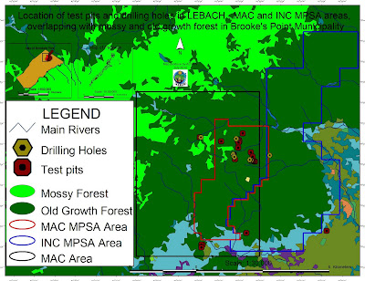
Location of test pits and drilling holes within the mining concessions and
their overlap with mossy and old growth forest in Brook's Point Municipality
Both the MPSA areas of MacroAsia and INC are located in ecologically valuable areas which include watersheds, hunting/ agricultural grounds, extractive reserves of Non-Timber Forest Products (NTFPs) such as Almaciga (Agathis philippinensis) resin, on which upland indigenous communities depend for their daily subsistence. Also indigenous peoples’ sacred and worship sites are found within the mining tenements of these companies.

Representatives of ELAC (Environmental Legal Assistance Center) are now filing cases against government officials and their respective agencies for having endorsed MAC and INC without securing first the needed social acceptability requirements and in disregard of the Strategic Environmental Plan (Republic Act 7611).

Say ELAC Atty. Edward G. Lorenzo: “the sustainable management of the entire Province is, in fact, governed by the SEP law which prohibits any human activity in those areas that are classified as ‘core zones’ and that – very unfortunately - are now part of MAC and INC mining tenements”. A indigenous member of the indigenous community of Gieb (Barangay Maasin, Brooke’s Point Municipality) also claims: “they (mining personnel of MAC) just entered our land without asking permission, and they removed our rice plants to excavate big ditches in our agricultural fields and also up into the mountains, only few meters away from the Balgtik (Agathis Philippinensis) trees that we sell and from which we depend for our survival”. According to another member of the same community: “MacroAsia peoples have removed soil and trees also in those sacred forest that we call lylien and that are inhabited by powerful super-human beings (Taw Kawasa)”.

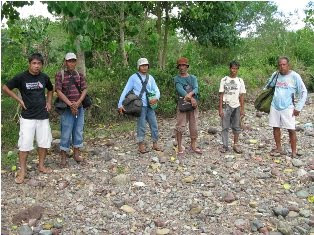
Between 12-16 July a geotagging field reconnaissance carried out by the ALDAW (Ancestral/Land Domain Watch) in collaboration with the Centre for Biocultural Diversity (CBCD) of the University of Kent has confirmed that MacroAsia test pits and drilling holes are found in ‘core zones’ (areas of maximum protection) around and even above 1,000 m ASL. Indigenous peoples trained on basic GPS and Geotagging technologies, with their own set of equipment divided into two groups to cover a large portion of the MAC and INC mining tenement area.

It appears that both MAC and INC have violated the basic tenets of the Strategic Environmental Plan (SEC) and also of the Indigenous Peoples Rights Act (IPRA Law), a national law protecting the interests of Indigenous Cultural Communities (ICC). Faced by this and similar accusations, the Provincial Government recently made a statement according to which MacroAsia and INC may not be allowed to operate in core zones, but their activities might be limited only to multiple/manipulative use areas. Again, ocular inspection and GPS data obtained by ALDAW and CBCD indicate the those portions of MacroAsia and INC mining concessions, which are outside the core zones, still include forested buffer zones which, obviously, do not fit by any means into the standard definition of ‘multiple/manipulative use zones’, where – according to the law – mining might be allowed. In fact, the mining claims of both MAC and INC are entirely located in ‘core zones’, ‘restricted zones’, agricultural and agroforestry areas that are subject to various cropping regimes. All these categories, according to the SEP law, should not be subject to any other form of large-scale extractive activity.

Also, lowland farmers are extremely concerned about the siltation of their wet-rice cultivation, as all irrigation water coming into their fields originates from the mountains where mining is supposed to take place. Members of academic institutions have suggested that: unless these precious water catchments are protected from mining operations, at least 50% of Brooke’s point sustainable agriculture, which requires irrigation, might be lost.

Says a spokesman of Alyansa Tigil Mina (the largest anti-mining advocacy group in the country) “Ironically enough the mining companies and the politicians who are endorsing them have also infringed the Philippine Mining Act which prohibits mining in old growth or virgin forest, proclaimed watershed forest reserves, wilderness area, and other areas of outstanding environmental value”. According to Atty. Mary Jean Feliciano of the ALDAW Network “in endorsing the mining exploration of both MAC and INC, the Sangguniang Bayan (Local Government of Brooke’s Point) has acted in contradiction with its own Municipal Comprehensive Land Use Plan (CLUP) for 2000-2010, in which mining was never considered as a development strategy and, in doing so, it has also bypassed the interests of local communities, as well as all forms of public consultations”.

Cornerstone of a CADT (Certificate of Ancestral Domain Title)

Undoubtedly, the endorsement by both Local and Provincial governments of the proposed operations of MAC and INC contravenes also those provisions contained in well know conventions [e.g. The Convention on Biological Diversity (CBD) and the UN Declaration on the Rights of Indigenous Peoples that the Philippine Government has already signed. Says a member of the Palawan advocacy community: “When the Government itself infringes its own laws so bluntly, it means that the fundamentals of democracy are breaking apart and a new form of state-led terrorism is coming into being to deprive hundreds of farmers and indigenous peoples of their traditional, and thus legitimate sources of life, just to benefit a handful of greedy and irresponsible businessmen and their cronies”.

On July 30, 2010 the members of the Palawan Council for Sustainable Development (PCSD) - a local government body in charge of the protection and sustainable management of the province - will meet to decide whether to issue a SEP clearance to the operations of MacroAsia and Ipilan Nickel Corporations. The future of one of the most pristine forests in the Philippines and the life of thousands of peoples who depend from it, is now in the hands of the Council.

Indigenous peoples and their networks, farmers, fisher folks, the Palawan NGO Network Inc (PNNI) and its associates, are uniting their effort to convince the PCSD to take a responsible decision which will ensure the sustainable future of Brook’s Point Municipality and of its biocultural diversity.


What you can do ...

Sign a Petition to Stop Mining in Palawan!


And address your concerns to:

Palawan Council for Sustainable Development
oed@pcsd.ph . and c/o Mearl Hilario mearlhilario@yahoo.com
FAX: 0063 (048) 434-4234

Honorable Governor of Palawan
Baham Mitra
abmitra2001@yahoo.com
FAX: 0063 (048) 433-2948

For more information watch ALDAW videos
http://www.vimeo.com/aldawnetwork
http://www.youtube.com/user/ALDAWpalawan
http://hub.witness.org/en/users/aldaw-network
or contact the ALDAW Network (Ancestral Land/Domain Watch) aldawnetwork@gmail.com  and Alyansa Tigil Mina (nc@alyansatigilmina.net / alyansatigilmina@gmail.com )

Thursday, May 27, 2010

PPgis.net Open Forum on Participatory Geographic Information Systems and Technologies


PPgis.net serves as a global avenue for discussing issues, sharing experiences and good practices related to community mapping, public participation GIS (PPGIS), participatory GIS (PGIS) and other geographic information technologies used to support integrated conservation and development, sustainable natural resource management and customary property rights in developing countries and among indigenous people worldwide. 
Members of the network are able to share information and lessons learned, post questions and announcements and upload and download resource documents which are relevant to the practice. 
 
The site is an online gateway for accessing discussion lists in English, French, Spanish and Portuguese, all dealing with participatory mapping.

Thursday, January 21, 2010

The Bulanjao Geotagged Report

On August 2009, a mission led by the Philippines-based Ancestral Land/Domain Watch (ALDAW) and the Centre for Biocultural Diversity (CBCD) at the University of Kent traveled to Barangay Sumbiling, Municipality of Bataraza, Province of Palawan (Philippines).

Geo-referenced audio-visual and photographic documentation was carried out in the Bulanjao range whose vegetation consists of a very unique type of forest growing on ultramafic /heavy-metal rich soils. The area is home to at least four plant species that are classified as vulnerable and two of them have already been included in the IUCN Red List.

In spite of its unique ecological features, the Bulanjao range has been subjected to mineral exploration and development by the Rio Tuba Nickel Mining Corporation (RTNMC). RTNMC is a Filipino-Japanese partnership holding a mining concession area of about 5,265 hectares.

RTNMC and its partner, Coral Bay Nickel Corporation (CBNC), need to mine nickel ores as part of the expansion of their new Hydrometallurgical Processing Plant (HPP) project. However, one the conditions specified in the Environmental Compliance Certificate (ECC) issued to them in 2002, is that “core zones” - as identified by the Strategic Environmental Plan for Palawan (Republic Act Republic Act 7611) should not be included in the areas of mining operations and, this, of course includes the Bulanjao range.

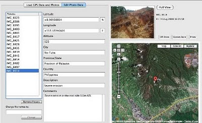
Starting at an elevation of about 40m ASL, the ALDAW/CBCD mission followed the mining road to reach the highest portions of the Bulanjao range. Geo-tagging evidence indicates that erosion on the Bulanjao mining road is occurring also at low elevations. During the rainy season the water creates deep clefts on the roadsides, hence penetrating the soil and fostering road collapse. No mitigating measures have been put into place to reduce erosion. A huge crater-like excavation has been found at 566m ASL. and land slides, induced by road construction, have been documented around the sources of the Sumbiling river, at almost 900m ASL. The latter is the most important water source for both lowland farmers and indigenous communities.

Marylin Samparan, a local IP living in the area told the mission: “time will come when our children will no longer recognize the names of trees, the footprints of animals, the birds’ songs. This will be the time when the forest will be gone, the mining companies will be gone, the rivers will no longer flow…and us? We will still be here”.

On 15 August 2009, the mission established that mining road had already reached an altitude of 859m ASL – and its exact location was defined through the following GPS coordinates (+ 8.59322548 N Latitude and + 117.36516571 E Longitude).

Mission’s findings have now been compiled into a geo-tagged report, which is being used by local indigenous communities to support their legal struggle against mining in Bulanjao.

Source: The ALDAW NETWORK

The ALDAW NETWORK (Ancestral Land/Domain Watch) is an advocacy-campaign network of Indigenous Peoples jointly constituted by NATRIPAL (United Tribes of Palawan) and BANGSA PALAWAN PHILIPPINES (Indigenous Alliance for Equity and Wellbeing) on August 2009.

Friday, January 08, 2010

Interview with Steve deRoy about the role of networking and communication in PGIS practice


In this interview, Mr. Steven DeRoy illustrates the power of networking and the importance of integrating this practice into the daily realm of PGIS. These professional exchanges create an opportunity to dialogue with likeminding professionals, allowing practitioners to share ideas and approaches to solve common challenges. Maps also play a vital role in communicating ideas amongst different parties and for advocating change in current affairs

Friday, September 18, 2009

Web-Based GIS and the Future of Participatory GIS Applications within Local and Indigenous Communities

As resource managers search for strategies to meet the challenges posed by intense competition for scarce local resources, the implementation of Community-based GIS applications have become widespread. Besides mapping, the Participatory GIS (PGIS) projects create a peaceful medium for community groups and public officials to meet, exchange views and also learn to develop trust for each other. However, PGIS projects face many problems including the lack of basic supporting infrastructure and services. The adoption of the Internet as a platform for PGIS applications therefore raises concerns about the future of PGIS projects. While the Internet may open the participatory process, it can also hinder participation among local groups. In an era when PGIS applications have become important in the management of local resources, there is an urgent need to examine implications of the On-line PGIS project. Accordingly, in their paper, by the title Web-Based GIS and the Future of Participatory GIS Applications within Local and Indigenous Communities, Peter Kyem and James Saku assess the potential benefits and drawbacks of on-line PGIS applications within local communities.

Saturday, September 20, 2008

Management Change at UNOSAT

According to Alain Retiere, Director of UNOSAT, the programme has reached the required maturity to become independent from the administrative management of UNOPS and become fully part of the new United Nations Institute for Training and Research that the Secretary-General has entrusted ASG Dr. Carlos Lopes to lead together with the United Nations Staff College, in full coordination with the United Nations University. This process will bring to UNOSAT further training activities, which will increasingly be carried out by the United Nations under a unified management. UNOSAT will enjoy the additional opportunity of developing applied research on satellite solutions, and consolidate the UN training offer on satellite applications for key issues ranging from emergency response to sustainable recovery.

In parallel, UNDP has decided to mainstream satellite applications throughout its network of 166 country offices supported by its 40 regional technical centers to help face the main development challenges. A new trend is emerging within the “territorial approach to development”, where a more local and decentralized way of supporting development efforts in most vulnerable countries is being applied. Although all dimensions of the UNDP development agenda will benefit from mainstreamed satellite applications, environment and energy is the area that has been selected as key entry point, considering the urgent need to help local communities to face climate change challenges with the most appropriate tools including satellite and GIS applications.

Sunday, August 31, 2008

African Indigenous Peoples’ Workshop on effective use of GITs and ICTs in advocacy

I have just come back from Namibia where I attended the "African Indigenous Peoples’ Workshop on effective use of GITs and ICTs in advocacy" (Windhoek, 25-28 August 2008)

The workshop has been organised by the Indigenous Peoples of Africa Coordinating Committee (IPACC) with technical and financial assistance provided by the Technical Centre for Agricultural and Rural Cooperation (CTA), ERMIS-Africa, Cybertracker Conservation, Shalin Ry and the Rainforest Foundation UK.

Indigenous African leaders and technology intermediaries have shared experiences on how geo-spatial information technologies (GIT) are used by indigenous peoples to express their traditional ecological knowledge to decisions makers for the purposes of securing recognition and rights. Key case studies presented included participatory mapping by ToCADI and San groups in Botswana, Participatory 3 Dimensional Modelling (P3DM) by hunter-gatherer peoples in Kenya, GPS-based mapping experiences from Cameroon, DR Congo, Namibia and South Africa.

The workshop included also capacity building sessions on the use of Cybertracker and online mapping (Google Earth and Google Maps) and web 2.0 (web2fordev) applications like blogging, online video sharing, and use of electronic discussion groups including [ppgis]).

Web 2.0 applications have been presented and adopted as adds-on to GIT in support to networking, communication, alliance building and remote collaboration for advocacy.