Showing posts with label neogeography. Show all posts

Monday, August 05, 2013

The Future of PGIS: Learning from Practice? Symposium held at ITC-University of Twente, Netherlands on 26 June 2013

On Wednesday 26 June, 2013 the research group “People, Land and Urban Systems (PLUS)” of the University of Twente organized a full day international meeting on the topic of Participatory Mapping and Participatory GIS (PGIS/PPGIS). The day consisted in a public symposium entitled “PGIS: a toolbox transformed to a practice”, and an Expert meeting to discuss: “PGIS – what next? Preserving the practice in the Geoweb”.

The purpose of the symposium was to reflect on the milestones that PGIS has passed in the last decade bringing it from a mere collection of tools toward a pervasive practice. The expert meeting has been organised to discuss future directions, opportunities and threats for PGIS particularly in light of the growing importance of the Geoweb in spatial information collection and dissemination.

Below are the presentations delivered during the syposium:


Monday, November 29, 2010

From Community Mapping to Critical Spatial Thinking


Director of the University of California, Santa Barbara's Center for Spatial Studies Michael Goodchild discusses "From Community Mapping to Critical Spatial Thinking: The Changing Face of GIS (geographic information systems)" in this National Science Foundation Distinguished Lecture. He discusses how individuals are using distributed, real-time data enabled by social networks to define landscapes that have been suddenly altered by floods, hurricanes and other acts of nature.


Source: National Science Foundation

Sunday, February 07, 2010

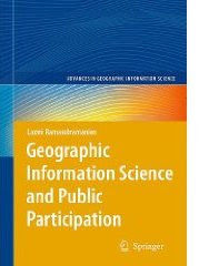
Geographic Information Science and Public Participation

Computer-mediated participation is at the crossroads. In the early heady days of the digital revolution, access to "high" technologies such as GIS promised the empowerment of marginalized communities by providing data and information that was previously hidden away from public view. To a great extent, this goal has been achieved at least in the U.S. and Western Europe – data about a range of government initiatives and raw data about different aspects of spatial planning such as land use, community facilities, property ownership are available a mouse-click away. Now, that the public, have access to information, are we able to make better plans for the future of our cities and regions? Are we more inclusive in our planning efforts? Are we able to foster collaborative governance structures mediated by digital technologies?

In Geographic Information Science and Public Participation (Advances in Geographic Information Science), Dr. Laxmi Ramasubramanian discusses these issues, using a three-part structure. The first part of the book is theoretical – it reviews the literature in the field, establishes a framework to organize the literature and to link three different subject areas (participation and community development, GIS and other related technologies, and planning processes). The second part of the book discusses a series of success stories, case studies that review actual situations where participatory planning using GIS has enabled community wellbeing and empowerment. These case studies vary in scale and focus on different planning issues (planning broadly defined). The final part of the book steps back to review alternative scenarios for the future, exploring where we are headed, as the technologies we are using to plan rapidly change.

The foreword for the book is written by Prof. Bill Huxhold.

Tuesday, February 02, 2010

Digital Cartography

Digital Cartography from dynamicmediainstitute.org on Vimeo.

By Andrew Ellis, Alexander Wang, Students at the Dynamic Media Institute, Massachusetts College of Art and Design

Digital Cartography is a short documentary film on the transition of maps into their digital form. In this film we speak with programmer and mapmaker Jeffrey Warren from the MIT Media Lab and Dietmar Offenhuber from SENSEable City Lab at MIT. We explore the cultural, economic and technical aspects of mapmaking and how they affect the way we communicate with one another.

In our interviews with Jeffrey and Dietmar we learn about the social and geographical ramifications of building maps and how designers can implement their literacy in communication design to explore different avenues for mapping. Participatory mapping such as Open Street Maps and psychogeography and the virtual dérive are some of the themes discussed around the history and future of mapping in the digital age. Jeffrey gives us a demonstration on low cost arial photography using a helium balloon and a consumer digital camera to stitch photos onto google maps.

Friday, November 13, 2009

Peter Poole reports on his experience with community mapping


In this interview, Peter Poole traces the evolution of a map-making methodology which commenced with his introduction of GPS to the Inuit community of Pangnirtung in 1989 and was incubated throughout the 1990’s by a series of ‘tenure mapping’ projects in the Amazon the Arctic and Asia. Tenure maps depict indigenous names, resources and special places on scaled maps, intended as evidence in negotiating land settlements.

Most tenure mapping methods rely upon external cartographic expertise. The “no-name” method enables communities to control the complete information cycle: gathering raw data, their conversion to information, its application.

The interview describes the search for cheap, simple, appropriate geomatic technology.

During several tenure mapping projects in the Amazon, a two-tier arrangement evolved whereby community-based teams would gather raw field data, the most critical task, and indigenous associations or support NGO’s, set up mapping units to serve the field teams.

The interview shifts focus to an overview of global community mapping completed by Peter Poole. In this, he concluded that, in terms of expertise, accessibility and accomplishment, the Philippines. He also drew a broad distinction to tenure mapping in America, a continent whose indigenous peoples sharing a in common ‘500 years since Columbus’ experience, and Africa, where this model does not work and where community mapping is taking off in a refreshing variety of directions.

The interview concludes with three lessons learned:
  • Yes, communities can make their own scaled maps.
  • The most successful of emerging mapping centres are those whose services are accessible to all communities.
  • This capacity-building approach to map making equips and inspires people to diversify their skills in environmental information management. These skills will be wasted unless provisions are made to follow up tenure mapping projects with either further training or employment.

Saturday, June 20, 2009

Map symbols and coding means

Map symbols should be designed or chosen according to principles of logic and communication to serve as a graphic code for storing and retrieving data in a two or three dimensional geographic framework.

Appreciating the logic of map symbols begins with understanding the existence of three distinct categories, including point, line and polygons (areas).

Maps and 3D models include generally a combination of all three. These tree main categories can be further differentiated by variations in "hue" (color), "gray tone value", "texture" and "orientation", "shape" and "size".

Each of these variables or their combinations excel in portraying particular features and their variations.

When using color (hue) for characterizing areas, decoding is made simpler when darker means "more" and lighter means "less". Color conventions allow map symbols to exploit idealized associations of water with blue and forested areas with green. This the combination of the two, implies that dense primary forest is dark green, secondary forest green, and grassland light green, and that deep waters are dark blue and shallow waters light blue .

"Size" is more suited to for showing different in amount of count, whereas "variations in gray tone" are preferred for distinguishing differences in rate or intensity. Symbols varying in orientation are useful mostly for representing directional occurrences like winds, migration streams or other. Line symbols best portray water courses, roads, trails, boundaries and may combine different variables, including color and size (thickness). A heavier line readily suggests greater capacity or heavier traffic than a thin line implies.
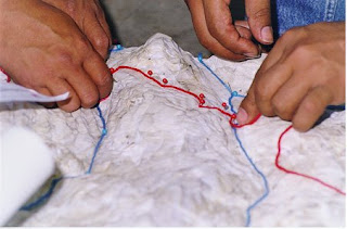
Each symbol should be easily discernable from all others to clearly distinguish unlike features and provide a sense of graphic hierarchy. A poor match between the data and the visual variables may frustrate and confuse the map user.

While in planimetric mapmaking the only limitation in the choice of symbols is fantasy (with logic), participatory 3-D modeling (P3DM) frequently depends on the availability of materials, particularly for point features which are generally represented by push and map pins. Lines and polygons can be easily represented by color-coded yarns and different color paints.

Standardization of symbols serves for ready unambiguous recognition of features and promotes efficiency in both map production and use, exchange of data and comparison. Maps and models sharing a common graphic vocabulary are definitely more powerful in convening the intended message and decoding simpler.

Monday, May 04, 2009

Participatory 3D Modelling in Bale, Ethiopia

MELCA Mahiber, an Ethiopian NGO member of the African Biodiversity network (ABN), facilitated the construction of a large Participatory 3D Model covering 1,575 sq. km (at a 1:12,500-scale) in Bale and West Arsi, Ethiopia.

The exercise has been done to assist local communities in planning out a more sustainable management of the area, reviving local bio-cultural diversity and supporting local environmental education.

More information on the exercise is found here.

Wednesday, January 14, 2009

2009 PGIS / PPGIS Photo Competition launched by CTA

The Technical Centre for Agricultural and Rural Cooperation ACP-EU (CTA) has launched a Photo Competition. Participants can win prices up to a maximum of EUR 900! CTA and partners are creating a multimedia multilingual training kit to support the spread of good participatory mapping practice. The training kit will promote examples of participatory mapping from around the Globe. A collection of images will be included in the photo library of the kit.

The competition has been launched to enrich the library with a wide variety of examples and applications from around the world. The competition allows development practitioners and researchers to share photographic records of their experiences with other peers and contribute to a product (the training kit) which will be freely available in different languages in 2010. More about the competition, its legal conditions, guidelines for submission and procedures of selection and awarding is found on the recently launched CTA web site dedicated to Participatory GIS (PGIS) practice.

Sunday, January 11, 2009

Trends and Technologies in Where 2.0

Geospatial expert Andrew Turner discusses the current evolution of Where 2.0 and how it is affecting the entire landscape of Web 2.0 and next generation applications. This webcast was recorded live on Oct. 24, 2008.


Andrew also published a book: "Introduction to Neogeography" published by O'Reilly.

Monday, December 22, 2008

Video documentary "Giving Voice to the Unspoken: now available with subtitles in Arabic, Fijian, Italian, Swahili and Turkish.

20-minute video production showing the hands-on aspects of Participatory 3D Modelling (P3DM). The video supports all practical aspects of P3DM described in the resource book "Participatory 3-Dimensional Modelling: Guiding Principles and Applications" and documents in detail an exercise conducted within the Pu Mat National Park, a protected area in Vietnam.


Thanks to voluntary translations :-) the video is now available with subtitles in Arabic, Fijian, Italian, Swahili and Turkish. More languages to come soon.

If you are interested to embed this video on your web site or blog, follow this link.

Sunday, November 23, 2008

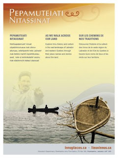
Innu Place Names Website

Labrador Innu launched the first comprehensive cultural website dedicated entirely to Aboriginal place names. Called Pepamuteiati nitassinat (‘As We Walk Across Our Land’), the website gives access to over 500 Innu place names in Labrador, as well as stories, photos, and video clips associated with the names. The website can be explored at http://www.innuplaces.ca/ . Innu Nation Grand Chief, Mark Nui, said, “Place names are very important to our people because they are a gateway to our history on the land. Many younger Innu who have gone through the provincial educational system have never learned these names. We hope that the website will help them learn about their culture and history.”

Lots of place names in Labrador come from the Innu (e.g. Minipi-Lake from Minai-nipi,
meaning ‘burbot lake’), but others were given by pilots, mining companies, settlers and outfitters and were imposed on places that already had Innu names. The website will enable the Innu and members of the general public to start using the Innu place names, to learn about the meaning of the names and how to pronounce them.

Other Aboriginal groups have been doing place name research over the years, and some are in the process of publishing their own websites (e.g. James Bay Cree and Norwegian Sámi). However, Pepamuteiati nitassinat is the first, comprehensive one put on line to date.

Grand Chief Nui pointed out that “Over thirty years of research with our Elders went in to this website. It’s a gift from our Elders to younger Innu people. It’s part of our Elders’ legacy. It’s also an important part of our intangible cultural heritage that will help educate people about the richness of our history and traditions.”

The website was made possible by contributions from many institutions and agencies including multimedia company Idéeclic, Environment Canada, Parks Canada, Memorial University Linguistics, and Canadian Boreal Trust. The Innu Nation wishes to acknowledge the generous financial support of the Department of Canadian Heritage through Canadian Culture Online.

History of the website project

  • The Innu place names available on the website were collected in the context of a number of research projects going back to the mid-1970s.
  • The biggest source of place names for the site is a 1980 mapping project. Over 500 maps at 1:50,000 scale were cut and taped together to form two giant maps. One was laid on the gym floor at Peenamin McKenzie School in Sheshatshiu and the other in the parish hall in the former community of Davis Inlet. Older hunters were invited to walk about on these maps to point out the locations of place names as well as old travel routes, camp sites, caches, birth places and good hunting and fishing places.
  • Only seven of the 34 older hunters who worked on the 1980 mapping project are still living.
  • A great deal of validation work was undertaken with respect to the places names which was done by ethnolinguist, José Mailhot, and anthropologist Peter Armitage, with the collaboration of Marguerite MacKenzie, Sebastien Piwas, George Gregoire, Jean-Pierre Ashini, Basile Penashue, Tony Penashue, and several Innu Elders.
  • Project managers for the website project were Kanani Penashue and Peter Armitage.

What’s on the website

  • The site features a searchable database of over 500 Innu place names.
  • Each place name record in the database contains information about the meaning of the name, how to pronounce it, and its location. Site users can click on an audio icon to hear the pronunciation of each place name.
  • The site has an interactive map showing the locations of the place names.
  • Background information on how Innu place names are constructed is presented.
  • Video clips and photographs show people what the named places look like or document land use activities there.
  • Audio narratives from Innu Elders and youth tell stories about events and people associated with certain place names.
  • Future phases of the website will add more place names, video clips, photos, and audio stories.

Source: Press relase by Natuashish (Labrador), 21.11.08

Saturday, September 20, 2008

Management Change at UNOSAT

According to Alain Retiere, Director of UNOSAT, the programme has reached the required maturity to become independent from the administrative management of UNOPS and become fully part of the new United Nations Institute for Training and Research that the Secretary-General has entrusted ASG Dr. Carlos Lopes to lead together with the United Nations Staff College, in full coordination with the United Nations University. This process will bring to UNOSAT further training activities, which will increasingly be carried out by the United Nations under a unified management. UNOSAT will enjoy the additional opportunity of developing applied research on satellite solutions, and consolidate the UN training offer on satellite applications for key issues ranging from emergency response to sustainable recovery.

In parallel, UNDP has decided to mainstream satellite applications throughout its network of 166 country offices supported by its 40 regional technical centers to help face the main development challenges. A new trend is emerging within the “territorial approach to development”, where a more local and decentralized way of supporting development efforts in most vulnerable countries is being applied. Although all dimensions of the UNDP development agenda will benefit from mainstreamed satellite applications, environment and energy is the area that has been selected as key entry point, considering the urgent need to help local communities to face climate change challenges with the most appropriate tools including satellite and GIS applications.

Sunday, May 18, 2008

Launch of the Participatory Mapping Training Kit announced


Participatory mapping and development practitioners, activists and researchers identified the lack of training materials as a major constraint in the spread of good participatory mapping / PGIS practice. An initiative launched by CTA and other development partners will lead to the production of a modular, multimedia and multilingual training kit for trainers. The kit will ensure that participatory mapping and communication practices evolve and spread in an ethically conscious manner, ensuring that indigenous and other marginalised communities are effective in documenting, representing, and communicating their spatial knowledge, while taking a high degree of control over the process. It is understood that good practice would add value and authority to local knowledge, facilitate inter-generational knowledge exchange, contribute to building and supporting a cohesive community identity, and support sustainable planning through collaborative decision-making.

Monday, April 07, 2008

Journey of our Life


A 14-minute participatory video production by PAFID - Mindanao documenting a journey to the land of the ancestors of Higaonon Indigenous Peoples living in Portulin, Bukidnon, Philippines. The virtual journey recreates experiences lived up by the members of the community in using a physical participatory 3D model (P3DM) to document, share across generations and safeguard their intangible cultural heritage.

Friday, April 04, 2008

2008 Indigenous Planning Conference "Leading Change: Blending Indigenous and Western Planning Tools" (1-3 October 2008, Anchorage, Alaska, USA)

The Leading Change conference (1-3 October 2008, Anchorage, Alaska, USA) is sponsored by the American Planning Association’s (APA) Alaska and Hawaii Chapters and the Indigenous Planning Division. The three-day conference will bring together planners, tribal leaders, and community members to share local experiences, planning tools and practices that reflect a commitment to honoring history, cultural identity, tradition, and land tenure. Conference participants will share stories from their own communities organized around general topic areas including land use and natural environment; governance, nation building and leadership; local control, community sustainability, and resilience; culture, education, and community services; economy; and infrastructure, public services, and facilities.

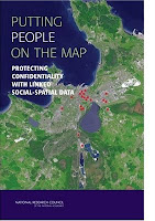
Putting People on the Map: Protecting Confidentiality with Linked Social-Spatial Data

Precise, accurate spatial information linked to social and behavioral data is revolutionizing social science by opening new questions for investigation and improving understanding of human behavior in its environmental context.
At the same time, precise spatial data make it more likely that individuals can be identified, breaching the promise of confidentiality made when the data were collected.
Because norms of science and government agencies favor open access to all scientific data, the tension between the benefits of open access and the risks associated with potential breach of confidentiality pose significant challenges to researchers, research sponsors, scientific institutions, and data archivists. Putting People on the Map finds that several technical approaches for making data available while limiting risk have potential, but none is adequate on its own or in combination. This book offers recommendations for education, training, research, and practice to researchers, professional societies, federal agencies, institutional review boards, and data stewards.