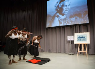
 The story is told often in Queenie’s own words and shows the many ways that indigenous people are connected to the land, it discusses issues such as mining of sacred sites, dreaming sites, skin groups - the Australian indigenous governance system, rainbow snake, massacres and parts of the history of growing up as an indigenous child during the impacts of white settlement. As Queenie was an acclaimed artist it also contains many images of her artwork, her maps of her country and sacred sites.When Queenie passed away these traditional ‘law’ practices ceased. Many years before Queenie had revived these annual practices after they were stopped during the settlement time, it was in the 1980’s that she insisted that they begin again. It has been 10 years since her death and the work on the book began between the author and the female elders, to keep Queenie’s legacy strong. Funds from the book are returned to the community for that purpose. It is a tragic reality that Queenie’s generation are the last remaining elders of the area who hold the land based knowledge of sacred sites, these people will all be gone within 2 years yet this is not seen as an urgent need in Australia by the Government, to provide resources and training to indigenous people to map these sacred locations and the associated knowledge.
For more information about the book go to http://www.writtenintheland.com/ or http://www.culturalmapping.com/
