The associated interests of woodcutters, cattle farmers and mineral enterprises have increased the rate of deforestation and contamination of rivers, and they seriously damage the forms of social organization and the modes of production of indians, marrons and other agents who depend on land and water resources in Amazonia. The actions intented to reduce the pressure on wooden species have been very ineffective. Under the effect of world market, iron and steel production increases the exploitation of coal made from trees. The forests are on the aim of many woodcutting companies and illegal charcoal mines, what increases the destruction of wood resources, and this causes impacts on rivers and igarapés (the small rivers common in the Amazon). Soy cultivation conquers more land and expands quickly according to the dynamics of the commodities market. Those projects have a very intense predatory component and they follow the logics of general price raising of commodities as fresh meat, soy, paper and cellulose, pig iron, cast iron and wood. The growing-up of these businesses is helped, simultaneously, by huge projects directed to cattle breeding, soy cultivation, dendê cultivation (a tree with fruits containing a vegetable oil, which is intensely used in the industry), eucalyptus cultivation, wood exploitation, besides many mining and metalurgical activities, provocating a massive destruction in the Amazon. The State-builded infrastructure in order to support those projects (docks, roads, hydroelectric plants, rocket launch sites) affects in the same way the inhabitants of the area, in addition to this we have the so-called areas of environmental protection that make the access to territories and their resources more restricted. The New Social Cartography Project of the Amazon (PNCSA) – executed by UFAM, UNAMAZ, CNPQ, FORD FOUNDATION and many political organizations representing social agents – proposes to elaborate a series of fascicles which show phenomena and make it possible to produce a critical review of the social, economical and ecological situation in the experience of social agents.
Cartographing research practices and self-cartographing help the affected social agents (marrons, indians, small farmers, settlers, fishermen, artisans, coal miners) to appropriate the results of these techniques and to guide their action of social and environmental changing. The meaning of affronting economical, environmental and political interventions that may interfere harmly on the life conditions, social and physical reproduction shows up the content of many actions.
The elaboration of the fascicles, the discussions and correlated activities (researching, identifying, codifying, mapping, cartographing) correspond to the positions and interests of the agents who formulate these activities and all this results in an appropriation of knowledge by those who produced it.
Project coordinators: Alfredo Wagner Berno de Almeida (Universidade Federal do Amazonas, Manaus, Brazil) and Rosa E. Acevedo Marin (Universidade Federal do Pará, Núcleo de Altos Estudos Amazônicos, Belém, Brazil)
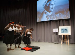 The story is told often in Queenie’s own words and shows the many ways that indigenous people are connected to the land, it discusses issues such as mining of sacred sites, dreaming sites, skin groups - the Australian indigenous governance system, rainbow snake, massacres and parts of the history of growing up as an indigenous child during the impacts of white settlement. As Queenie was an acclaimed artist it also contains many images of her artwork, her maps of her country and sacred sites.When Queenie passed away these traditional ‘law’ practices ceased. Many years before Queenie had revived these annual practices after they were stopped during the settlement time, it was in the 1980’s that she insisted that they begin again. It has been 10 years since her death and the work on the book began between the author and the female elders, to keep Queenie’s legacy strong. Funds from the book are returned to the community for that purpose. It is a tragic reality that Queenie’s generation are the last remaining elders of the area who hold the land based knowledge of sacred sites, these people will all be gone within 2 years yet this is not seen as an urgent need in Australia by the Government, to provide resources and training to indigenous people to map these sacred locations and the associated knowledge.




 An Atlas of Radical Cartography

