Showing posts with label climate change. Show all posts

Tuesday, December 10, 2019

How mapping changed behaviour

A study of the Samoan experience of participatory three-dimensional modelling (P3DM), a practice which has been widely promoted by CTA, has shown that it has led to better natural resource management, helped local communities become more resilient to climate change and brought about significant changes in the relationship between governments and local communities.

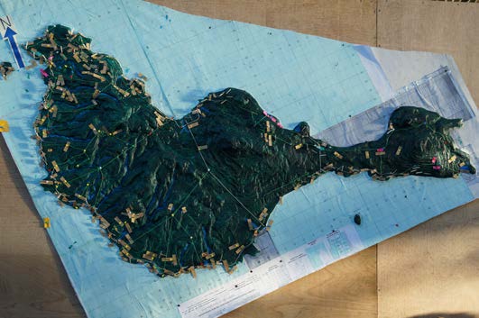
P3DM is a mapping progress which enables local communities to ‘populate’ geo-referenced relief models with their own knowledge about physical features, such as rivers and villages, and the way in which their territory is used, for example for hunting, fishing and growing crops. The maps help to enhance a sense of belonging and local knowledge and many communities have used them to assert their rights, identify resources and opportunities, and devise new strategies for managing the land.

Giacomo Rambaldi, who has led CTA’s work on P3DM, was contacted in 2016 by Barbara Dovarch, a PhD candidate from the University of Sassari, Italy. She was keen to look at the effectiveness of P3DM and Rambaldi suggested she carry out her fieldwork in Samoa. Here, a 5-year project funded by the Global Environment Facility and carried out by the Samoan Ministry of Natural Resources and Environment, had used P3DM to sensitise local communities to climate change. Rather than being initiated by the local communities and their partners, as normally happens, P3DM was introduced by a government department as a way to reach communities and gain their trust.

Dovarch found that prior to the introduction of P3DM, community representatives tended to adopt a very passive attitude during consultations with the authorities. “Government officials usually adopted a lecturing style in meetings with community members, using PowerPoint presentations and information leaflets, often without success,” noted Dovarch in her report. However, the P3DM process provided local communities with the opportunity to express their own understanding about their land and take a more active role in resource management. The building of the models also enabled young and old people to talk to one another and exchange knowledge about nature, culture and history.

According to community members who spoke to Dovarch, the process encouraged the government to change the way it behaved towards local people. Now it is much more willing to ‘listen’ rather than ‘teach’. Government officials moved away from ‘consultations’ towards active participation, which helped to build trust on both sides. As far as the government officials were concerned, the P3DM process – in Dovarch’s words – “completely changed the attitude and approach of communities towards their own environment and land management.”

The government of Samoa was initially exposed to P3DM techniques through CTA’s ICT4Ag activities. Since then, it has not only contributed to the development of 19 P3DM models over a 4-year period, but also committed itself to playing an important role in popularising the technique in other parts of the Pacific region, beginning with Tonga. Dovarch described her findings in a CTA working paper in the ICTs for agriculture series, Participatory 3D modelling in Samoa: Triggering behavioural changes in climate change resilience.

Sunday, May 01, 2016

Inspiring speech by Hindou Oumarou Ibrahim at the Signing of the Paris Climate Change Agreement


PARIS, 22 April 2016 - UN Secretary-General Ban Ki-moon invited all world leaders to a signing ceremony on 22 April at UN Headquarters for the historic climate agreement that was reached in Paris in December last year. At the request of the Executive Office of the Secretary-General, UN-NGLS led a process for civil society to apply to attend or speak during the opening session of the signing ceremony, involving facilitation of a civil society Selection Committee, who reviewed more than 200 applications received. Ultimately, Ms. Hindou Oumarou Ibrahim from the Association des Femmes Peules Autochtones du Tchad (AFPAT) in Chad was selected as the civil society speaker for the opening ceremony of the event.

Hindou is a member of the Executive committee of the Indigenous Peoples of Africa Coordinating Committee (IPACC), for which she is a representative of the Congo Basin Region, with a background in indigenous peoples' rights and environment protection with the three Rio Conventions (Biodiversity, Climate Change and Desertification) with multiple responsibilities.

She has organized a series of international workshops on scientific and traditional knowledge systems in partnership with UNESCO, IPACC, CTA, CI and the government of Chad.

Below is the last of a series of three film productions concerning Hindou's the activities centred on merging traditional and scientific knowledge systems and related participatory three-dimensional mapping (P3DM) activities in Chad.

Three-way dialogue on climate change from CTA on Vimeo.

Among the many bus stations of N’djamena the capital city of Chad, travellers coming from the countryside know where to unpack their concerns. The path of Aladji Ibrahim leads to AFPAT, an organisation which represents the rights of Indigenous Peoples, in this case the Bororo herders. Here is where the story starts, a deeply touching one. A story centred around climate change adaptation, where the manufacturing and use of a 3 dimensional model helps bridging the gap between traditions and modernism, local producers and government officials, village elders and scientists, local communities and public powerhouses. Last but not least this film documents how participatory three-dimensional mapping (P3DM) can facilitate the management and mitigation of conflicts over shared natural resources. It shows also that P3DM can support the promotion of human rights and represent a formidable medium for facilitating dialogue among development partners.

French version of the film.

Other film productions part of the series:

Dangers in the bush, map of good faith: https://vimeo.com/53836701
Climate Governance: A matter of survival for nomadic pastoralists: https://vimeo.com/37458698

Further reading:

__________ 2012. Influencing regional policy processes in Climate Change Adaptation through the interaction of African pastoralist traditional knowledge and meteorological science; A Contribution to the Nairobi Work Programme on Impacts, Vulnerability and Adaptation. IPACC. 22 pg, September 2012

Thursday, October 29, 2015

Samoa’s Ministry of Natural Resources and Environment receives award for engaging civil society via participatory mapping

On 25 September 2015 the Forestry Division of the Ministry of Natural Resources and Environment of Samoa (MNRE) received a Public Service Innovation and Excellence Award in the Environmental Friendly/Sustainable Development Initiative team category for the successful implementation of the Integration of Climate Change Risk and resilience into Forestry management in Samoa (ICCRIFS) Project.

The ICCRIFS Project is a 4 year project funded by the Global Environment Facility (GEF) through the United Nations Development Program (UNDP). The goal of the project is to integrate climate change risks into forestry management in Samoa. After being trained by the Technical Centre for Agriculture and Rural Development (CTA) in practising Participatory Three-Dimensional Modelling (P3DM) in 2012, staff of the ICCRIFS Project successfully facilitated a total of 18 P3DM exercises with communities in various sectors including water, forestry, tourism. The first P3D Model to be implemented (covering villages from Laulii to Falevao) became a very effective planning tool. It helped engaging the community by building capacity, knowledge and skills on environmental management, and ways to adapt and mitigate climate change.

The 2015 Public Service Innovation and Excellence Awards ceremony, took place on the 25th of September 2015 as part of the 4th annual Public Service Day. The Public Service Day is held to commemorate, celebrate and recognize the public sector’s contribution and service into achieving the national development of Samoa. Close to 50 Government Ministries and Public Bodies took part in this year’s celebrations.

These Awards are used to recognize the dedication of public servants in achieving their respective Ministry’s and Office’s objectives. Nominations of potential awardees were solicited from the general public in August and were thereafter assessed by an independent panel consisting of 3 members: the Chamber of Commerce President on behalf of the private sector, SUNGO Interim President Vaasilifiti Moelagi Jackson on behalf of the civil society, and the Chairman of the Commission.

The general public as well as schools were invited to take advantage of the opportunity to engage with Government agencies to gain an in-depth understanding of the functions and roles of each of the participating agencies and how these relate to their everyday life.

Related postTop UN officials Helen Clark and Naoko Ishii praising outcome of P3DM activities in Samoa

More information on the P3DM process and case studies are found here and here.

Monday, June 29, 2015

Using Participatory Three-Dimensional Modelling (P3DM) to facilitate community decision making: a case study from the Vanuatu Pacific Adaptation to Climate Change (PACC) project

This report focuses on the Pacific Adaptation to Climate Change (PACC) project in In Vanuatu, which focuses on coastal zone management, and specifically the coastal roads on the island of Epi, which are being damaged by flooding and coastal erosion. The project is working with local communities to develop appropriate solutions that contribute to more resilient infrastructure.

The PACC Vanuatu project team identified participatory three-dimensional modelling (P3DM) as a valuable tool to facilitate community participation and decision making in the project.
P3DM involves the building of three dimensional (3D) relief maps by communities, combining local knowledge of geography and land use with geo-referenced data. The map then forms the basis for discussion and decision making on project interventions.

Download report

Related Vlogpost: Participatory 3D Modelling (P3DM) for bottom-up decision-making in Vanuatu

Friday, October 03, 2014

Case study on the use of P3DM to facilitate effective contribution of civil society in the Caribbean islands in planning for action on climate change

This case study documents CANARI’s experience in
piloting the use of P3DM in the Caribbean and identifies
lessons learnt and recommendations on how it can be used to strengthen the capacity of CSOs in the islands of the
Caribbean to play a larger and more effective role in
biodiversity conservation and sustainable development.
The case study was written as part of the CANARI project
Consolidating the role of civil society in biodiversity
conservation in the Caribbean islands, funded by the John
D. and Catherine T. MacArthur Foundation.

Citation: Bobb-Prescott, N. 2014. Case study on the use of participatory three dimensional modelling to facilitate effective contribution of civil society in the Caribbean islands in planning for action on climate change. CANARI Technical Report 401, Laventille.

Related video production: She becomes more beautiful: Capturing the essence of Tobago Island for a better tomorrow

Friday, May 23, 2014

A three-way dialogue on climate change

The peasant, the decision-maker, the researcher and Participatory 3d Modelling

In the numerous bus stations in N’Djamena, the capital of Chad, all passengers, arriving from other parts of the country, with their bag of worries, know where to find a sympathetic ear. Aladji Ibrahim’s steps lead him to Hindou Oumarou Ibrahim, the coordinator of AFPAT, an organisation which defends the rights of Bororos pastoralists. This is the start of a story of people, animals, space and human rights with, at centre stage, an outstanding “character”: a three-dimensional model. This tool, displayed within an administrative office in Baïbokoum, almost 600 km from N’Djamena, is proving to be an unexpected medium for promoting the dialogue between peasants, local authorities, scientists and national public authorities, all concerned about climate change, reducing conflicts between faming and herding communities, territorial development, the promotion of human rights, ...


Three-way dialogue on climate change

This documentary completes a trilogy of films, produced in phases.

November 2011: IPACC and AFPAT co-organised, with the support of the Technical Centre for Agricultural and Rural Cooperation (CTA), a workshop on pastoralism, traditional knowledge, meteorology and the development of policies for adapting to climate change. Climate governance was the focus of the debates, with around the table indigenous herders from South Africa, Kenya, Namibia and Niger, meteorologists, ministers and representatives of international organisations. This workshop culminated in the so-called N’djamena Declaration , which emphasised the urgent need to involve vulnerable groups in the development of policies to mitigate climate change. It recommended the use of participatory approaches and visualisation tools to represent the available space at community level.


Climate Governance: A matter of survival for nomadic pastoralists

July–August 2012. The Baïbokoum workshop on Participatory three-Dimensional Modelling (P3DM), with as its theme the prevention and management of conflicts between farming and herding communities, implemented the N’djamena recommendations. The combination of the knowledge of indigenous communities and the skills of experienced facilitators resulted in the production of a physical three-dimensional model depicting in detail an area of 720 sq km at a 1:10,000 scale.


Dangers in the bush, map of good faith

One year on, what has become of the model, the result of the multi-stakeholder dialogue? The third documentary answers this question. It narrates the journey undertaken by Hindou Oumarou Ibrahim to Baïbokoum. At her destination, she meets pastoralists and edgy authorities. They would like to popularise the model with farmers, traditional community leaders and in local development programmes. But they lack the necessary technical and financial resources. Their cry from the heart is conveyed to N’Djamena by the tireless advocate of the cause of Bororos herdsman: Hindou Oumarou Ibrahim.

Monday, May 05, 2014

Participatory 3D Modelling (P3DM) for bottom-up decision-making in Vanuatu


In April 2013 a community consultation and a participatory planning process took place on the Island of Epi in Vanuatu. Residents assembled and populated with a rich set of data a 1:20000 scale physical 3D model of the island and its surrounding coastal waters.

This video documents how participants took ownership of the process and made informed decisions on how to address climate change challenges.

The activity has been carried out and the video produced in the framework of the GEF-UNDP-SPREP-supported Pacific Adaptation to Climate Change (PACC) project.

Source: click here.

Read more:

__________ 2013. Vanuatu PACC Finalizes Project Scope on Epi Island using Participatory 3D Modelling. Newsletter No. 1, Vol 1. Pacific Adaptation to Climate Change (PACC) project


The P3DM process and other cases are documented in this video collection on Vimeo and on this web site.


Sunday, December 22, 2013

Involving communities in project planning using Participatory 3D modelling (P3DM): the experience of Epi Island, Vanuatu

Senior students of Epi High School felt privileged when they were chosen to construct the model of Epi island using a modeling technique known as Participatory 3 Dimension Modelling (P3DM), as part of a key community consultation process by the Pacific Adaptation to Climate Change (PACC) project on the island of Epi. With the help of students, each community members were able to use tagging pins and colored paper strips to label current physical features on the island as well as map out future developments recommended by each area councils.

Land boundary is a critical challenge in Vanuatu. On Epi alone, such project implementation requires acquisition of land prior to any physical work being carried out. The use of Participatory 3-D modeling gave land owners and area council representative a physical overview of the roading issues. After recognizing the problems and the proposed solutions under the PACC Vanuatu project, the land owners and area council representatives agreed to give ' for free' their land and resources for PACC project implementation on Epi. Under the PACC project where the thematic area is Coastal Infrastructure, the road relocation project is aimed at building resilience and improving access for the people to the main service and commercial center on the island.

The current 72km road from South through West to the North of Epi is located along the coast. A physical feature evident along this road is the continuous erosion of the road due to either heavy downpour resulting in landslides along road sides, , running water drenching the road surface making it difficult to travel on, and ocean waves impact on the road sides, washing away the roads.

Following the successful outcome of the Participatory 3-D model consultation, the PACC team selected VARSU area to commence the road relocation project.The VARSU area council on North Epi is the first community to physically map out a new 10 km road in the interior of the island, with the objective of having climate proof roads that will not be washed away at the coast, and to have better and safe access to markets.

Source

Thursday, August 15, 2013

Beneath the Surface ~ Mapping Union Island - A P3DM exercise, 2013


Here is the story of a participatory mapping exercise done on Union Island in St. Vincent and the Grenadines in the Caribbean.

The second of such exercise to be done in the Caribbean under the theme "working with people and nature to find solutions to climate change".

The film gives a glimpse into the, happiness, trials and tribulations of the local people as they participate in a unique participatory mapping process led by Sustainable Grenadines Inc.(SusGren), a local NGO, with support provided by TNC and CTA.

The film also speaks to the local people’s ideas of sustainable development and livelihood opportunities for them and their families.

It also highlights the changes the local community has experienced over the years in their environment and how they have already started to adapt. It certainly takes you in the life of a Unionite and their small island....

midst the challenges of a degrading marine and coastal environment, development pressure from tourism and climate change local people through the mapping process came together with one voice to develop a plan of action for their island future.

Language versions: English | Spanish | French | Portuguese (coming soon)

The film has been produced with funding provided by CTA. Director: Jess Phillimore

Tuesday, October 16, 2012

Participatory video - an effective evaluation tool


Trainees appraise the P3DM process using "PV"

SCARBOROUGH, 14 October 2012  The volume of information to be collected from informants on their natural resources, climate change impacts and the measures they use to cope or adapt to these impacts, is best dealt with using a video camera, said Kathrina Collins, President of the Union Island Environmental Attackers from St. Vincent and the Grenadines.

Trainees appraise the P3DM process using "PV"
Katrina recalled that learning how to use the video camera supplied by CANARI for the participatory video (PV) exercise was a lot of fun, but she was more comfortable while working on the participatory 3D model of Tobago.  Katrina was one of the regional trainees who participated in the 14-day workshop which led to the manufacture of the first participatory 3D model (P3DM) to be created in the Caribbean.

Damika Marshall, Environmental Officer from the Tobago House of Assembly (THA) who was another trainee, said that PV was used to highlight the lessons learnt from the P3DM process and ways to make it better.  She agreed that learning to use the video equipment was enjoyable and added another dimension to the workshop.

Similar sentiments were shared by their counterparts who were divided into groups to work on the video project.  Their task was to evaluate the P3DM process using video.

The team captured footage highlighting Tobago’s natural resources, peoples’ dependence and relation to the resource base, the process of making the 3D model, and the views and opinions of stakeholders involved in the process.

Desiree Sampson, a professional videographer, briefed the trainees on the concept of "five W’s and one H" otherwise known as “the six helpers”.  Each letter representing a question that has to be answered for the story to be considered complete: who, what, where, when, why and how.  This approach is used as the basis for gathering information when doing research and gathering news.
The trainees interviewed stakeholders to find out their experiences on climate change impacts, exploring exactly what happened, when it happened, where it took place and why it happened.  They also conducted interviews among the group of trainees to capture their feedback on the model building process.

Katrina Collins, Candice Ramkissoon, and
Shawnaly Pascal download and view
footage collected during the workshop
The trainees were also shown how to develop and use a storyboard to guide production.  A storyboard is a set of graphic images laid out in particular sequence to tell a story.  Each participant contributed ideas to create the storyboard.

As with each activity at the workshop, there was a daily review of the daily achievements.  Damika said that every evening the footage shot during the day was viewed by the trainees and facilitators.  The team assessed its visual quality and content value for selection and incorporation in the final video production.  In some cases, the team decided that some interviews had to be redone and footage captured again to improve the quality.

Lessons learnt

All the trainees said that using the video equipment to capture the stories was a great idea.  Damika felt that using a video to tell a story is quite an effective way for sharing ideas and experiences with the community since “not everyone can read or understand a lengthy written report or has the time or inclination to do so”.  She however added that policy makers would need more than a video to make decisions regarding climate change and to understand the ramifications of their policies.

Kemba Jaramogi captures footage of an informant adding
details to the model, while Kenn Mondiai, P3DM expert
looks on.
Kemba Jaramogi from Trinidad said the video cameras used were small and as a result, not intimidating to interviewees.  She also said that the equipment was relatively inexpensive.

Kemba however noted that cost should not be the only consideration before purchasing this type of equipment.  “The quality [of footage] it produces is an important factor”, she said.

In summary, the trainees from across the Caribbean found the PV activity quite interesting.  They said that the production of a video for evaluation purposes was an interesting learning experience and at the same time, videography was an effective way for capturing and documenting the impact of climate change on communities through the eyes of the grassroots.


Related posts: 

Sunday, October 14, 2012

First Participatory 3D Model built in the Caribbean

Nationals from the region now ready and eager
to introduce P3DM in their countries

SCARBOROUGH, 13 October 2012.  One hundred and six Tobagonians participated in transposing their mental recollections of the impact of climate change on their natural resources and how they are adapting to climate change on the participatory 3D model of Tobago.  Informant, Lyris Walker called it a piece of work “for the people, by the people and of the people”.

Indeed, the importance of facilitating data collation from local communities was underscored by Philippines GIS expert, Kail Zingapan, when she stated that without inputs from the residents of Tobago, the model could not be built.  The model covers an area of 1,152 km² and consists of a 1:10,000-scale version of the island and its surrounding waters up to a depth of -100 meters.

Under the theme: "She becomes more beautiful: Capturing the essence of Tobago today for a better tomorrow", the title of the event and the legend for the model were agreed upon by residents of Tobago during an introductory and planning workshop which was coordinated by CANARI’s Senior Technical Officer and Manager of Forest, Livelihoods and Governance Programme, Neila Bobb-Prescott on September 25 2012.

The organizers - CANARI and technical and financial sponsors, CTA and UNDP GEF Small Grants Programme - invited many Caribbean nationals, from NGOs, CBOs, government agencies, intergovernmental technical agencies and academia as well as their Tobago counterparts, to the 14-day workshop where they gained skills in building the model and in documenting and assessing the process through the use of participatory video (PV).  Two participatory mapping experts from the Philippines and Papua New Guinea facilitated the model-building process in which students from secondary schools across Tobago were also involved.

Making the model

Trainees are guided on contour tracing by Kail Zingapan,
GIS expert from the Philippines
Trainees and students noted that building the model turned out not to be as easy as it looked, as the base map, which was prepared by a team from the UWI, had to be traced onto cardboard and then carefully cut into individual elevation layers.

These layers of cardboard were carefully placed and glued on top of each other and consolidated and smoothened using crêpe paper.  White paint was subsequently applied to the cardboard model.
At that stage, the model was ready for accommodating data all originating from mental recollections of residents of Tobago.  These came from many sectors of the society - fishermen, farmers, reef tour operators, hunters, environmental groups, and academia.  Natural resources were identified, areas affected by climate change were pointed out and measures used to adapt to the changes were described.  All these contributions generated a total of 87 layers of information all displayed on the model.

Quality assurance 

At every stage of building the model, there were checks and balances as facilitators ensured code consistency and stimulated community cross-verification of input data.  Additionally, the information transposed on the model was also checked by technocrats from different departments of the THA.

A trainee adds elevation layers to the model
At the early stages of model making, residents pointed out that Little Tobago, a small island off the coast of Tobago, and other islets and rock outcrops were missing from the model.  All these being important landmarks for fisherfolk and sailors.  The facilitators acknowledged their absence.

Adam, one of the workshop participants who used to work at the UWI, rose to the challenge of preparing the needed contour map, far from his GIS lab and using a locally available ink-jet printer to plot the islets.  Kail obtained elevation data from the Internet, and one of the UWI graduate students helped Adam obtain the data concerning the depth of the sea.  And … magic …by the end the day, Little Tobago and other missing islets were placed onto the model and smoothed with crepe paper.

The progress of the activities was constantly under review by CANARI‘s facilitators, Nicole Leotaud - Executive Director and Neila Bobb-Prescott - workshop coordinator.  Morning debriefing sessions evaluated the previous day’s work and set an agenda for the day’s activity.

Handing over

At the end of the workshop, the people of Tobago handed over the model to the Tobago House of Assembly.  It was received by Hon. Gary Melville, Secretary for Agriculture, Marine Affairs, Marketing and the Environment.

The informants used a series of photographs on PowerPoint slides to explain what they felt was happening to the natural resources in Tobago and called on the authorities to take urgent action to address the impact of climate change.

Left to right: Neila Bobb-Prescott (CANARI),
Giacomo Rambaldi (CTA),
Hon. Gary Melville (THA) and Lamon Rutten (CTA),
examine the P3DM model of Tobago
A brief synopsis of the workshop was delivered by CANARI, and the representatives from sponsoring agencies - CTA and UNDP GEF Small Grants Programme - applauded all the stakeholders for their efforts.

CTA’s , Senior Programme Coordinator, Mr. Giacomo Rambaldi, said he was happy to see the outcome of the programme and UNDP’s Programme Assistant, Ms Sasha Jattansingh, extended sincere appreciation to all the stakeholders who had built the model.

One informant, Ms Laura Williams of Golden Lane, besieged policy makers not to allow the model to become a “dust enhancer” and added that the purpose for which the model will be used will determine the future of the island’s resources and its peoples.


Related posts: 


Tobagonians hand over the Participatory 3D model to the Tobago House of Assembly

Participatory 3D Model referred to as “visual conversation” tool

1:10,000 scale participatory 3D model of
Tobago produced by Tobagonians in the
 two-week workshop held at
Blenheim, Tobago
SCARBOROUGH, 12 October 2012. Tobagonians, today, handed over the participatory 3D model of Tobago to the Tobago House of Assembly’s (THA’s) Secretary of Agriculture, Marine Affairs, Marketing and the Environment, the Honorable Gary Melville.  The hand-over ceremony, which took place at the auditorium of the Tobago Hospitality and Training Institute at Mount St. George (close to where the model was built at Blenheim), was attended by students, informants, trainees from across the Caribbean, THA officials and facilitators from the Caribbean Natural Resources Institute (CANARI), the University of the West Indies (UWI) and Partners with Melanesians (PwM) - the NGO deployed by the Technical Centre for Agricultural and Rural Cooperation ACP-EU (CTA) to provide technical inputs into the manufacture of the model and delivery of P3DM / PGIS training.  Officials from CTA and United Nations Development Programme - Global Environment Facility Small Grants Programme (UNDP GEF-SGP) attended the ceremony; these two organizations provided technical and financial support to the P3DM and Participatory Video (PV) processes.

The ceremony marked the end of a 14-day workshop which was hosted by CANARI and the UWI in conjunction with the THA to pilot the building of the P3DM in the Caribbean.  The workshop, which was coordinated by CANARI’s, Senior Technical Officer and Manager of Forest, Livelihoods and Governance Programme, Mrs. Neila Bobb-Prescott, was held to train facilitators from around the Caribbean, in the use of participatory processes for communicating information relating to climate change and its impact on communities.  Part of the training also included using PV to evaluate the effectiveness of the P3DM process.

On October 11, CANARI’s Executive Director, Ms Nicole Leotaud, facilitated a session with stakeholders from Tobago to prepare a summary of the impacts of climate change in Tobago, outline how climate change is affecting them and the steps they are taking to adapt to these impacts.

On October 12, the stakeholders of Tobago presented the summary to the THA and called on the THA to use the information on the model to design policies to lessen the impact of climate change on their livelihood activities and the island of Tobago as a whole.

Anthony Cordner shares the  Tobago 'story' of
climate change during the handover ceremony at the
Tobago Hospitality and Training Institute
When listing the effects of climate change Tobagonians highlighted the following: decreased and erratic rainfall, dead areas of coral reefs, blurred dry and wet seasons, less fishes in the sea and increased coastal erosion.  Additionally, the group of stakeholders also spoke of the prevalence of bush fires on the island.

Fisherfolk reported that they have adapted to the changes by sailing further offshore to fish.  Some farmers indicated that they had switched from farming to fishing and others reported that they were digging wells closer to rivers to water their crops.  Laura Williams of the group Anse Fromager from the village of Golden Lane called on the THA to partner with communities to deal with the impacts of climate change.

Clement Bobb, President of the Tobago Cocoa Farmers
Association refers to the 3D model as
a “visual conversation tool"
Another informant, Clement Bobb, President of the Tobago Cocoa Farmers Association, told the audience that it was only through the workshop that he learnt that members of the association are noting springs drying up and are moving to alternative locations.  Mr. Bobb also said it was the sharing of information by all, including trainees from around the Caribbean, which led him to deem the 3D model a means for “visual conversation”.

Meantime, in receiving the model, Secretary for Agriculture, Marine Affairs, Marketing and the Environment, the Honorable Gary Melville expressed the THA and Executive Council’s “deepest appreciation” for the efforts of facilitators, funding agencies and all others who had a hand in creating the “visual conversation” tool.

The Secretary promised to increase the use of the participatory approach to deal with climate change.  He said the model was an example of the level of output that could be achieved when many organizations and people join forces for a common purpose.

Hon. Gary Melville, Neila Bobb Prescott from CANARI
and Lamon Rurren from CTA admiring
the completed 3D model 
Meantime, in an interview conducted after the ceremony, Mr. Lamon Rutten, Manager of Policy, Market and ICT at CTA, said he was happy with the level of enthusiasm displayed at the ceremony from all the participants and found the results coming out of the workshop “amazing”, since he knew the amount of effort that had gone into producing the model.  He pointed out that the use of conventional tools to gather information would have taken much longer and may not have yielded the same results. He also pointed to the sense of urgency, that Tobagonians expressed in their presentation, to do something to mitigate the impacts of climate change.  He expressed his hope that the same level of urgency stated by citizens would be felt by the politicians. Mr. Rutten manager thanked CANARI for the “tremendous” work done in facilitating the workshop and noted that without CANARI, the CTA would not have been able to achieve its goal of working within the Caribbean.

In addressing the ceremony, Giacomo Rambaldi, Senior Programme Coordinator at the CTA said he, like everyone else, was pleased with the model and glad to witness what had taken place.  Mr. Rambaldi, who has extensive experience in creating participatory 3D models, attended the last two days of the workshop.

Likewise, Sasha Jattansingh, Programme Assistant of the UNDP GEF Small Grants programme, said she appreciated the great work undertaken by CANARI, UWI, THA and participants in the workshop.
By and large, the ceremony was well represented by members from all the sectors that had taken part in the workshop.  Everyone who participated – students, informants and trainee facilitators – were awarded certificates.
Facilitators, trainees and informants pose with
Bheshem Ramlal (UWI)  and Giacomo Rambaldi (CTA)
after the handover ceremony 
Note: The following organizations were represented at the training and /or closing ceremony

Barbados: 

  • Caribbean Disaster Emergency Management Agency (CDEMA); 
  • Caribbean Institute for Meteorology & Hydrology (CIMH)

Dominican Republic: 

  • Consorcio Ambiental Dominicano (CAD)

Grenada: 

  • Caribbean Association for Youth Development (CAYD); 
  • Woburn Community

Haïti: 

  • Groupe de Action Francophone pour l'Environnement (GAFE)

Jamaica:

St. Lucia: 

  • Caribbean Environmental Health Institute (CEHI)

St. Vincent and the Grenadines: 

Trinidad and Tobago: 

  • Caribbean Natural Resources Institute (CANARI)
  • Caribbean Agricultural Research & Development Institute (CARDI); 
  • Institute of Marine Affairs Trinidad and Tobago (IMA); 
  • Trinidad and Tobago Red Cross Society
  • Office of Disaster Preparedness and Management (ODPM); 
  • Department of Natural Resources and Environment (DNRE), Tobago

US Virgin Islands: 

  • The Nature Conservancy (TNC)

Greater Caribbean: 

  • Caribbean Large Marine Ecosystem (CLME), IOCARIBE - UNESCO

Papua New Guinea

  • Partners with Melanesians (PwM)

International

  • Technical Centre for Agricultural and Rural Cooperation ACP-EU (CTA)
  • The UNDO GEF Small Grants Programme (GEF-SGP)


Related posts: 

Friday, October 12, 2012

Participatory 3D Modelling (P3DM) activities in Tobago featured on National Television


FRIDAY, 12 OCTOBER 2012 - Tobago Channel 5 News - Climate change is a very serious issue in the Caribbean and we often hear about this from scientists who explain the situation in a technical sense. But what about those on the ground that want to know exactly how it can affect them.

In collaboration with the University of the West Indies and with technical and financial support provided by the Technical Centre for Agricultural and Rural Cooperation ACP-EU (CTA) and UNDP GEF-SGP, the Caribbean National Resources Institute, CANARI, embarked on a project to allow Tobagonians to share their knowledge to others who may have questions about climate change. With the help of a new 3D model of Tobago built by the participants of the project, Tobagonians can learn about the issue plus other concerns the country may face.

Over 100 Tobagonians recently constructed a scale model of Tobago which will be used to measure climate change on the island. The project was done in attempt to allow Tobagonians to share information with each other about climate change and the effects on various areas. Nichol Leoto, a member of CANARI, gave details of the two week project.

She added that the experience for those who were a part of the project was amazing and will be a positive for Tobago and Tobagonians. Ms. Leoto made it clear though that it is not ending there. She said that this is just the starting point of a bigger intiative which includes policy making for Tobago.

Ms. Leoto said that CANARI will be returning to Tobago in two weeks to work more with civil society groups, community groups and NGO’s.

Source:  Tobago Channel 5 News


Related posts: 

Knowledge holders add value to the 3D model of Tobago

Historical and cultural knowledge emerges along with awareness on environmental change

SCARBOROUGH, 06 October, 2012.  Excitement is growing as the blank 3D model is populated with data.  What is astonishing is that nobody uses satellite images or existing maps where to source information.  All data comes from memory, and one added piece of information offers new cues to memory, hence everybody is discovering and learning by doing.

A team from Golden Lane add their data to the model
Day by day, more information is added to the once blank model.  The second group of informants arrives to transpose their information.  And still, members from the first group of informants are returning to the workshop because, according to them, they went off, did some research and have returned to “add more value to the model”.

The residents of Tobago, the actual custodians of local and traditional knowledge are eager to put their stamp on the model.  As the updating of the map legend continues, some of them are resolute in their view that present as well as past names of map features, like points, areas and lines must be included.

The participatory 3D model exercise is being facilitated by the Caribbean Natural Resources Institute (CANARI) and the University of the West Indies (UWI) with financial and technical assistance from The Technical Centre for Agricultural and Rural Cooperation ACP-EU (CTA) and the United Nations Development Programme, Global Environment Facility - Small Grants Programme (UNDP GEF-SGP).

Historical perspective

The excitement of the participants echoes around the Island and the P3DM initiative  is attracting keen interest from Tobagonians from all walks of life.  Laura Williams of Golden Lane returns to the workshop with Lyris Walker and Veslin Alleyne in tow; they have information for the model.

Gang Gang immortalised on the model!
Lyris says she is glad to be a part of the project because it is “for the people by the people”.  Pointing to places she had forgotten about, she says the project is successful because it is “very educational”.  She jogs her memory for details while consulting The changing society of Tobago, 1838-1900: Vol I and II a historical publication written by Susan E. Craig-James.  This historical publication should inform the P3DM, says Lyris.

Lyris, Laura and Veslin are excited to see the point on the model which identifies Gang Gang Hill in Golden Lane.  They tell of the legend that gave the hill its name: Gang Gang Sarah was a witch who flew from Africa to meet members of her family who were captured and brought to Tobago after being sold into slavery.  In Tobago, Gang Gang Sarah met and married Long Tom.  After her husband died, she attempted to fly back to Africa, but fell to her death from the top of the silk cotton tree which she had climbed to begin her journey.  She could no longer take off because she had eaten salt and salt makes it impossible for witches to fly!

Tobago has a rich cultural history, but the legends are heard less frequently as the years go by.  To preserve the island’s past, a Heritage festival is held annually to celebrate all aspects of the island’s history.

Climate change adaptation

Contributing to the participatory 3D model overwhelms Bryan Bain of Belle Garden.  He understands the importance of the exercise because he has seen the effects of unsustainable harvesting practices and climate change in his community.  He talks of crab catchers harvesting thousands of crabs weekly.

A fisherman from Castara is oriented to
the model by one of the trainees
He admits that he also harvested over two hundred crabs per week, in 2005.  Back then, he says, crabs walked “by the hundreds in the wetlands”, while at present only four or five perch above their holes.  As a result of the dwindling crab population, Bryan says he has stopped catching crabs and is now assisting in encouraging hunters to leave the young crabs to thrive.  He adds that he joined the Belle Garden Wetlands Association and Environment Tobago to meet like-minded people to preserve the environment.

Bryan also points to deforestation as a major problem in his area.  This, he observes, has lead to the shortage of wildlife in the forest, among other things.  He feels that the P3D model will make members of the community more aware of the damage they are causing.  Increased awareness, he notes, should bring about enough change in people's attitudes and trigger changes in the way they act.  He plans to build a P3D model of his village to enhance tourism.

Similarly, Goldberg Job, informant from Belle Garden, says people have to be encouraged to adapt to climate change by changing their lifestyles.  He says people must be told to tie the roofs to their houses to prevent these from being blown away during adverse weather conditions.  Additionally, he notes that fishermen should build bigger boats and invest in technology in order to continue fishing further afar from the coastline.  He wonders whether architects are part of the P3D model-making.  He is told that he is the architect, as well as the other informants.

The work on the participatory 3D model of Tobago continues apace.  Another group of informants is expected on Sunday.  If the trend continues, the same group of informants that came on Saturday and Friday will return to further contribute data on the model.


Related posts: 


Thursday, October 11, 2012

Participatory 3D model of Tobago seen as time capsule


SCARBOROUGH, 07 October 2012.  On the morning of Sunday 7 October, the air in the room where the participatory 3D model is being built, is tense but hopeful.  Trainees, facilitators and informants work at a steady pace, but there is animated discussion on the ICC Twenty 20 Cricket World Cup game between the West Indies and Sri Lanka, being played halfway across the world.  Later in the day, after much anxiety, the West Indies is declared the winner of the cricket match and there is a brief pause to celebrate!

A facilitator assists one of the informants in
putting detail onto the model
More than anything else, the screams of joy reverberating around the room remind the trainee-facilitators, facilitators and informants of their common heritage and shared geographical space.  The reflection on the impacts climate change is having on natural resources and on the actions being taken to deal with these changes takes on a new dimension.

Jacinthe Amyot of IOC-UNESCO/Marine Affairs Program, Dalhousie University/Canadian International Development Agency IYIP says that after hearing fishermen talk about the effects of the Orinoco river on the Tobago shrimp fishing industry, she has developed a keen appreciation for its effects.  She says this information will inform her actions in the future.

Cocoa farmers discuss their
contributions to the model
Jacinthe is one of a number of persons participating in this capacity building event, representing different government, inter-governmental, civil society and academia from across the Greater Caribbean.  These persons have been in Tobago since September 29th to participate in this training which is meant to introduce a participatory mapping method which could be adopted across the Caribbean region as it previously happened in Africa and the Pacific.

Meantime, a steady stream of informants continues to trickle in.  They had stayed at home in the earlier part of the day to watch the World Cup cricket match while others had gone to church, as is the local tradition.  Members of the Cocoa Farmers Association of Tobago (TCFA) and various fisherfolk associations throughout the island transpose their spatial knowledge on the model with the guidance of the facilitators.  The farmers talk about the climatic changes they have observed and they also identify areas where cocoa farms exist and verify other bits of information on the model.  The farmers share how changes in climate have affected the cocoa crop cycles and caused a high level of unpredictability over the years.

Clement Bobb, President of the Cocoa Farmers Association, says the “sporadic rainfall - short burst of intense rain followed by hot sun – means that there is a longer bearing season”.  This kind of weather is causing the trees to flower all year round, he says.  Mr. Bobb adds, “we do not know when to plant”.

A fisherman adds information to the model
Mr. Bobb does not own a cocoa farm but manufactures dark chocolates under the ‘House of Orlando’ brand.  Talking about the value of the P3DM workshop, the chocolate entrepreneur says its value will last for generations as it is a time capsule documenting the status quo of the island.

Similarly, informant Andre Greene, a fisherman from Parlatuvier, says the P3DM exercise is generating “vibrant information for the coming generations”.  He thinks that segments of the model would have to be updated as changes occur due to the impact of climate change.  On the issue of fish stock, Andre says it is “getting harder to find fishes in the sea, all year long”.  He has to go further out to the sea and stay further away from other fishing vessels.  He mentions that while he appreciates the value to the country of natural gas exploration taking place at Block 22 just off the north coast of Tobago, he has concerns that this activity may be a contributory factor to the low level of fish stock.

Continuous Evaluation

The first act of the day, as trainees and facilitators gather, is the assessment of the previous day’s activities and agreement on the agenda for the day.  Today, Nicole Leotaud, CANARI’s Executive Director and conservation biologist, takes the debriefing session a little further and does an assessment of the entire workshop.  She looks at the areas on the model that have been mapped and examines the information added about Tobago’s resources and the effects of climate change.  How locals adapt to the changes is also a part of the assessment, to the extent to which the information is being captured on the model.

In the meantime, as informants come and go, they transpose their mental maps on the model and check existing ones.  It is a process of constant cross-checking and verification marked by recurrent negotiations.

There is discussion, sometimes heated, on where lines, areas and points should be located.  When there is no consensus, CANARI facilitators and Participatory GIS experts Kenn Mondiai from Papua New Guinea and Kail Zingapan from the Philippines come in to assist.

The workshop is soon drawing to a close, with only four more days to go.  In that time, the facilitators look forward to welcome new teams of informants coming from the south western end of the island.


Wednesday, October 10, 2012

Blank 3D model of Tobago accommodates first set of community inputs

Informants express pleasure at being part of exercise

SCARBOROUGH, 04 October 2012.  Bubbling with excitement, informants who came from far and wide to help fill in the blank model of the P3DM of Tobago could barely contain themselves as they realize the importance of their knowledge.

Kail Zingapan, GIS expert being interviewed
by Clyde McNeil of Tobago Channel 5 
The room is buzzing with activity as the informants locate features on the map.  Four groups of trainee facilitators accompany Tobago residents in transferring their mental maps on the 3D model under the watchful eye of facilitators from the Caribbean Natural Resources Institute (CANARI), GIS expert Kail Zingapan from the Philippines and Kenn Mondiai of Partners with Melanesians (PwM). .

The island of Tobago, for which the participatory 3D model is being developed, is an island nation and part of the Republic of Trinidad and Tobago.  Tobago is the smaller of the two islands and has a land mass of approximately 300 km².  The P3D model represent the island at a 1:10,000 scale hence one centimetre on the model corresponds to 100 meters on the ground.  The island is home to the largest brain coral in the world and the oldest Forest Reserve in the Western Hemisphere - the Main Ridge Forest Reserve.

Democracy Walls

Teenager Zenniethe Balfour (in blue shirt) transposes data
on the model based on her recollection from memory
Not only are informants transferring their personal knowledge of Tobago, and its surrounding waters up to a depth of -100 meters to the model, but they are also sharing their feelings about the activity on a "Democracy Wall" in a specially marked off area on the wall of the workshop area.

The "Democracy Wall" provides one additional channel for participants to express themselves.  To contribute to the Wall, the informants write their notes on small pieces of paper which they then post onto the Wall with tape.  Open ended headings such as ‘I believe …’ and ‘I feel …’ stimulate contribution.

Teenager Zenniethe Balfour of the Anse Fromage Ecological Environmental Protection Organisation - Golden Lane sticks her contribution to the Wall:  “I did not know Tobago is shaped like a snake”.  She says that listening to the contributions of others as they transfer images from their mental maps is a learning experience.  In fact, she says she is learning many new things about her community although she has been living there for the past eighteen years.

Asked to convey her feelings about contributing to the blank model, Zenniethe smiles broadly and says she feels “important”.  In terms of the value of the entire exercise, she says there is value in knowing the natural resources in one’s community.  “As you become aware you will instinctively protect”, she says.

Selecting data for the model

Goldberg Job of Belle Garden shares his views during the
orientation  session prior to engaging with the 3D model
Prior to inserting pins and outlining yarn on the model, informants had to agree on colour codes and symbols for particular features such as different types of forests, reefs and other features of importance to them that would be located onto the model.  Symbols and colours were associated with legend items to compose the map interpretation key.  Throughout the session, informants sought clarification on what types of information could be placed on the model and how they could symbolise it in line with the existing legend.

A fisherman asks why he is seeing government offices, seaports and airports but no banks on the chart.  CANARI’s facilitator Neila Bobb-Prescott responds by asking him to what extent the position of a bank is impacted by climate change.  He scratches his head, pinches his chin, nods and moves on to another question.

Laura Williams from Anse Fromage adds detail to the model
Before engaging with the model, informants take part in short orientation sessions with facilitators.  These sessions include mutual introductions, sharing information on the 3D modelling process, climate change and what the concept of “participatory” means.  The orientation sessions also sought to learn about the informants understanding of these concepts and their views on what value they felt the development of this model has for them and would have for Tobagonians.

Laura Williams from the Anse Fromage Ecological Environmental Protection Organisation is busy working on the model, identifying areas in her village, Golden Lane.  Golden Lane is a rural village on the north eastern end of Tobago.  The Great Courland is one of a few beaches in the world where the endangered leatherback turtles gather every year to lay their eggs.  She says she is devoted to ensuring that Golden Lane is well represented; she wants it to be known that the Courland Watershed, the Great Courland, is not so great anymore as it is being heavily impacted by climate change.  Noting that deforestation is a big problem in the area, she says man is contributing to  this destruction.

Laura says the P3D model will make people of the community more aware of the impact their actions are having on the environment.  People outside of the area will also be aware of the problems, she says.

With a wealth of information being shared and mapped by the knowledge holders, the workshop facilitators are looking forward to welcoming more and more members of the communities across Tobago who are expected to arrive over the coming week.

Related posts: