Showing posts with label Ethiopia. Show all posts

Monday, September 24, 2012

Participatory 3D Modelling (P3DM): five years after receiving the World Summit Award

In collaboration with national and regional partner organisations, the Technical Centre for Agricultural and Rural Cooperation EU-ACP (CTA) is supporting the dissemination and adoption of P3DM practice in ACP countries. The practice is now well established in Africa and the Pacific. Its introduction to the Caribbean  is planned for October 2012 via a partnership with CANARI and the University of the West Indies.

Since 2007 WSA award winning Participatory 3D Modelling P3DM (P3DM) in Fiji, the P3DM practice has been adopted in many parts of the world including Australia, Bhutan, Cambodia, Chad, Colombia, East Timor, Ecuador, Ethiopia, France, Gabon, Ghana, Guatemala, Guyana, India, Italy, Kenya, Malaysia, Morocco, Nepal, Nicaragua, Papua New Guinea, Solomon Islands, Sri Lanka, Uganda, Thailand, Vietnam, and many other countries.

In Kenya, Indigenous Peoples employed the practice to document their biophysical and cultural landscapes, enhance inter-generational knowledge exchange.  They also found it to add value and authority to local knowledge, improve communication with mainstream society, improve spatial planning and address territorial disputes.


In Ethiopia P3DM has been taken up by farmers to plan out community-based land reclamation and sustainable management of resources.


The Indigenous Peoples of Africa Coordinating Committee (IPACC), a pan-African network, has been spearheading the adoption of P3DM in the continent to improve awareness at policy-making level on the relevance of location-specific knowledge in climate change adaptation processes. As an example, the use of P3DM by pygmies in Gabon allowed them to gain visibility and establish peer-to-peer exchanges with local government institutions.


In 2012 Pastoralist Mbororo People in Chad practiced P3DM to manage spatial conflicts with farming communities.

In Solomon Islands coastal communities benefitted from P3DM to analyse issues related to climate change and identified ways to adapt to it.


UNESCO, IFAD and other development agencies have created resource materials (publications) making specific reference to the method.

In collaboration with IFAD, CTA has developed a training kit http://pgis-tk.cta.int supporting the spread of good practice in generating, managing, analysing and communicating spatial information. The kit includes a module on P3DM.

Friday, June 10, 2011

Report back on a short mission to Ethiopia - PGIS practice


I was recently in Ethiopia where I had the opportunity to deliver two seminars on PGIS practice, with focus on Participatory 3-Dimensional Modelling (P3DM) work done in Ethiopia. The 1st seminar took place at ILRI on May 26. It attracted approximately 20 participants from various agencies including ILRI, IWMI, CGIAR System-wide Livestock Programme, the New Agriculturist magazine and Biodiversity International.
The 2nd seminar organised by the Ministry of Agriculture in collaboration with GIZ took place at the offices of GIZ and was attended by representatives from MoA, GIZ, WFP, FAO, WFP-MERET, Sustainable Land Use Forum (SLUF), Oromisa SLM program, Austrian Development Cooperation, and the Sustainable Land Management (SLM) Program. Mr. Daniel Danano, coordinator of the SLM confirmed their interest in collaborating with CTA to (i) translate the handbook “Participatory 3-Dimensional Modelling: Guiding Principles and Applications; 2010 edition” in Amharic, (ii) broadcast the video production “Mapping for Change” on national TV, (iii) and to implement P3DM process in “hot spots” within project watersheds.
Great interest in the practice was also expressed by representatives from the WFP and FAO. All participants requested copies of the P3DM manual and of the PGIS Training Kit 

Saturday, April 09, 2011

Mapping for Change: The experience of farmers in rural Oromiya, Ethiopia

This 16 min film documents a participatory mapping experience of Ethiopian farmers in the Oromiya Region. Over a period of 12 days close to 140 people contributed to the construction of a 3-dimensional map covering – at a 1:10,000-scale - a total area of 672 sq km.


In a relatively degraded environment where soil fertility plummeted after the clearance of the natural forest and food security is at stake, residents of four woredas (Welmera, Ejere, Adea berga and Mulo) convene in the village of Telecho to map their own land.
Challenged by an unchartered process they successfully complete it, and while populating the map, they compare their past and present ecosystems and identify the root causes of their problems. They finally propose with their own solutions.

The experience marked their life …

Wednesday, February 16, 2011

Ten step process for producing a Participatory Video. The Telecho Experience


This video was shot during the making of a participatory video in Telecho village, Highlands Ethiopia. It is meant to show in 10 easy steps the process used during this participatory video training. Fernanda Baumhardt and Patricia Santos trained 14 youth age 14- 16 that have no access to electricity and TV to hold a camera, speak on a microphone and do interviews, making their own film.

This Video has been produced in the framework of the project: "Promotion of Collaborative Spatial Information Management and Communication in East and Southern Africa", Telecho, Ethiopia

Project coordination and funding: Technical Centre for Agricultural and Rural Cooperation ACP-EU (CTA) and MELCA - Ethiopia

Monday, January 17, 2011

Looking Through a Mirror at our Past and Present: Account of a P3DM Exercise in Ethiopia

The leathery scent at the venue hall was nothing more than the confirmation that we were working in rural Ethiopia, in a village called Telecho, some 30 kilometres north of Holeta. We had just gathered with 20 delegates coming from Ethiopia, Kenya, Tanzania, South Africa, Uganda, Cameroon and Benin to co-facilitate a participatory mapping exercise implemented by more than 130 villagers coming from 28 kebeles located within the area and foothills of a mountain known as Foata.

The exercise – organised by MELCA-Ethiopia, a national NGO and supported by the Technical Centre for Agricultural and Rural Cooperation ACP-EU (CTA), was a response to a call by the community for assistance in rehabilitating its environment which suffered heavy deforestation and soil degradation over the past decades. After several month of preparation, the exercise took place on 8-18 December 2010 in the village of Telecho amidst a golden landscape shimmering with wheat, teff and rye at maturity stage intersected by dark brown strips of ploughed land and exposed soil cloths weltering in the choking sun.

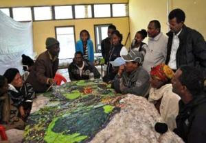
Close to 140 people worked in shifts on the model which covers – at a 1:10,000-scale - a total area of 672 sq km including portions of four woredas namely Welmera, Ejere, Adea berga and Mulo. Assisted by the trainers, 14 students, three teachers and the foreign delegates (the trainees) manufactured the blank model. Approximately 110 elders representing 28 kebeles contributed in overlapping groups to the elaboration of the map legend and the depicting of their mental maps onto the model. A number of representatives from local government units contributed to the exercise as well.

The assembling of the blank model using 3-mm thick sheets of carton board and measuring 2.8m x 2.4m, took three days while the depiction of the landscape and the location of features relevant to the community, took additional six days.

Selected elders introduced the first group of participants to the draft legend which was verified and further enriched in terms of items and their descriptors. Once completed, the model stored 48 layers of information including 25 point-, 5 line- and 18 area types. A count of point data done at the end of the exercise revealed that within the area there were 38 schools, 23 health posts, 113 sacred trees, 8 markets, 861 settlements and much more.

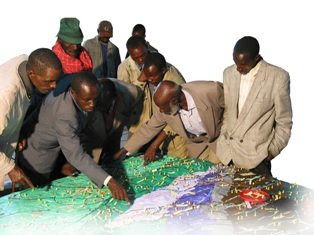
In terms of process, villagers from the first group introduced the second group to its task and the latter did the same with the third group. This ensured a full transfer of ownership of the entire process from the facilitators, who kick-started the process, to the informants, which proudly presented their output to the wider community and government representatives on the day of the inauguration and closing ceremony. Villagers worked with great attention and passion while depicting the landscape of their woredas. Animated discussions, exchanges, and negotiations characterised the process involving both men (the majority) and women. Traditional dances animated the start of the activities in the morning while work kept on rolling until night at the light of a generator.

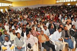
A bull was slaughtered in anticipation of the closing ceremony which took place on 18 December 2010. The event signified the apotheosis of the process where elders (man and women) presented the legend and information featured on the 3D model and described the process which led to its production. The audience was composed of approximately 300 villagers originating from all 28 woredas, representatives from the parliament, local government, CTA, the Finnish Embassy and delegates coming from 9 African countries, representing NGOs and universities.

During the various phases of model making, participants were given the chance to express themselves and provide written feedback on the process using so called “democracy walls”. Democracy walls are large sheets of craft paper labelled as “I noticed”, “I learned”, “I discovered”, “I felt”, “I would like to suggest” where individuals can stick A5 sheets of paper where they have marked a statement related to the “label” and concerning the process experienced. In addition a professional media team documented the process and conducted interviews, and a group of youth was trained and assisted in producing a Participatory Video (PV).

Participating villagers reported that working on the model elicited powerful memories of a past landscape characterised by lush forests and permanent river courses, and made them realise how much the conversion of the matural habitat had impacted (negatively) on their life. Participants stated that through a self-reflection process they realised that their non-sustainable handling of the resources base had led to impoverishment of soils and decrease in crop yield, and that the present situation was threatening their livelihoods and mere subsistence. They stated that the process of model building created learning environment and gave them a sense of purpose. “The P3DM process enables the community to look at itself using the model as a mirror” wrote a villager on a card featuring on the “Democracy Walls”.

Written statements made by villagers (in Amharic) while working on the 3D model:

“I felt that - as we destroyed the natural resources in our surroundings, we lost the soil, the forest, wild animals and more. This in turn is harming ourselves and creating problems to coming generations”.
“I felt that I could compare what we did on the map with what existed in the past [in the real world], and this makes it clearer about what to do in the future”.
“I noticed that it [the process] helped me understanding the importance of participation. I also realized that the community has valuable knowledge that we were not aware of.” 
“I noticed that the P3DM process enables the community to look at itself using the model as a mirror. It builds capacities and that is important for the development of the country.”

Source: Democracy Walls, Telecho, 17 December 2010

The large gathering on 18 December reinforced the message as villagers involved in the mapmaking shared their realisations, increased awareness and statements of intentions. The presence of Government representatives who seemed bewildered by the view of the model at its unveiling, was much appreciated by the community members, and reinforced their perception of being considered and listen to in their pledge for working jointly for a better future. In this context villagers decided to convene a larger meeting to look into a series of actions which would help them rehabilitate their degraded land.

A few days after the completion of the exercise, MELCA was granted additional financial support by the Finnish Embassy to sustain follow-up activities related to the rehabilitation of the environment in the project area. The 3D model will play an important part in this process as it represents the most updated and most relevant repository of local spatial information and a planning tool which can be easily mastered at village level, as it is fully understood and endorsed by the local populace.

Last but not least, the national and international trainees expressed their intention to replicate the process in their areas.

Authors: Giacomo Rambaldi / CTA and Million Belay MELCA-Ethiopia
Images: G. Rambaldi / CTA© and Damian Prestidge / CTA©


Tuesday, July 06, 2010

High resolution participatory satellite imagery interpretation in Southern Etiopia


A SPOT 5 scene was used to explore indigenous land use patterns, pastoral rangeland management and infrastructures with Borana pastoralist, a customary institution in Oromia region, Southern Ethiopia. Video material produced in August 2009. Contribution: Massimiliano Rossi

Sunday, October 04, 2009

Participatory 3D Model of the historical Wechecha mountain complex, Ethiopia

MELCA Mahiber, an Ethiopian NGO which is part of the African Biodiversity Network (ABN) facilitated the construction of a Participatory 3 Dimensional Model (P3DM) of the historical Wechecha mountain complex, which is found in Oromiya Regional State, adjacent to Wolmera and Sebeta Awas Woreda in Ethiopia.

Once completed the model has been inaugurated by a Representative of the President of Federal Democratic Republic of Ethiopia. Over 500 people participated in the ceremony including members of the House of People Representative Councils, governmental officials and representatives from international organizations, CSO and local communities.

The 1:10.000 scale model covers an area of 24 km by 28 km. Over 40 students and representatives from youth groups constructed the blank model. Residents of the area, especially elders, were invited to populate the map with their spatial knowledge. In the process information about the mountain area has been shared across generations and between local communities and other stakeholders, opening the door for deeper discussions on the sustainable management and safeguarding of both local culture and environment. The local Governors were very supportive. They played an active role in the process together with the organisers.

The objective of the exercise was to document the Traditional Ecological Knowledge (TEK) of resident communities, and add value and authority to it in order to increase the value external authorities would attach to it when it comes to collaborative natural resource management. A second objective of the exercise was to enhance the transfer of TEK the younger generations.

Now thet the model is completed it will as a reference environment where local people, government officials and other stakeholders can discuss management and rehabilitation plans.

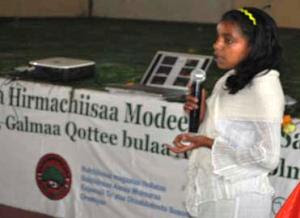
Kalkidan is a 15-year old student at Holeta Primary School. She witnessed how this model created an opportunity for her and her friends to learn a lot from the local elders. At the inauguration she stated the following: “We youngsters didn’t think that elders know, but now, after participating in the construction of this Participatory 3 Dimensional Model, we are convinced that our elders have a deep knowledge about their environment” She recalled that the elders were the main actors on the scene.

At the ceremony Elders locaed their places of origin on the model and talked about them. They couldn’t hide their feeling that their area is becoming degraded and pleaded for concerned bodies to address this problem. The government representatives also endorsed the model and reiterated that it should not be just for looking at and admiring.”

Dr. Tewoldebithan G/Egziabher, Director of the Federal Environmental Protection Authority and Chairman of MELCA’s General Assembly delivered the model to Holeta Town and Wolmera Woreda Administrations on behalf of MELCA. He told to the Administrations to use the model as a reference for taking measures.

According to Million Belay the Director of MELCA related initiatives will follow: There will be an intensive planning process aiming at rehabilitating the Wechecha Mountain complex and we will ensure that the model will be central to it. Schools located at the foothills of the mountain will make use of the model in their curriculum like it is currently happening in Nessuit Kenya, where a similar model has been constructed in 2006. Teachers use it to facilitate pupils learning about their environment, geography and cultural landscapes. In addition, Mr. Belay stated that the 3D model will be used for scientific research, on the relationship between people and the environment, and to study the impacts of land degradation on the livelihood of local communities.

Wednesday, June 17, 2009

P3DM after the 2007 World Summit Award

In November 2007 "Participatory 3D Modelling (P3DM) for Resource Use, Development Planning and Safeguarding Intangible Cultural Heritage in Fiji" was proclaimed as one of the four winners of the “Worlds Best e-Content 2007” in the World Summit Award category e-Culture.

Here is an account of what has happened since the exercise was carried out in Fiji.

Since 2005 (year in which the project in Fiji was implemented) Participatory 3D Modelling (P3DM) and been adopted in development contexts in many parts of the world (http://www.p3dm.org/) including Cambodia, Colombia, East Timor, Ethiopia, France, Guyana, Italy, Kenya, Malaysia, Nepal, PNG, Australia and other countries.

The 2007 WSA recognition added value and authority to the method and gave worldwide recognition to its quality and appropriateness.

In Kenya P3DM been used by Ogiek, Yiaku and Sengwer Indigenous Peoples to document their biophysical and cultural landscapes. The objectives of these community-led interventions included enhancing inter-generational information exchange, adding value and authority to local knowledge, improving communication with mainstream society, improving planning on sustainable management of natural resources and addressing territorial disputes.

In Ethiopia P3DM has been used to assist stakeholders in the Bale region to plan out sustainable management of the area, revive their bio-cultural diversity and support local environmental education.

The Indigenous Peoples of Africa Coordinating Committee (IPACC), a pan-African network of 150 organisations adopted the method and is spearheading its adoption in the African Continent to improve awareness at policy-making level on the relevance of location-specific traditional ecological knowledge (TEK) in climate change adaptation and mitigation processes. Read more.

UNESCO has been supporting the adoption of P3DM in Niger and Kenya in the context of the of the Convention for the Safeguarding of the Intangible Cultural Heritage paying specific attention on the opportunity for safeguarding traditional ecological knowledge as part of overall intangible cultural heritage and its integration into the education curricula.

In collaboration with national and regional partner organisations, the Technical Centre for Agricultural and Rural Cooperation EU-ACP (CTA) is supporting the dissemination and adoption of P3DM practice in ACP countries. Regional capacity building exercises are scheduled in Central Africa (Gabon and DCR), West Africa (Niger) and Southern Africa (Botswana) in 2010 and 2011.

In collaboration with a number of development agencies, CTA is spearheading the production of a training kit supporting the spread of good practice in generating, managing, analysing and communicating spatial information. The kit includes a module on participatory 3D Modelling.

Other initiatives include the ongoing online participatory translation of a video documentary on P3DM “Giving the Voice to the Unspoken” using the free platform http://dotsub.com/

Saturday, May 09, 2009

Interview with Mr. Million Belay, coordinator and facilitator of the P3DM exercise recently conducted in Bale, Ethiopia

Q1: Dear Million, could you briefly introduce yourself and the organisation you are working for?

My name is Million Belay. I am Ethiopian. I am a graduate in Tourism and Conservation, currently doing PhD on bio-cultural diversity. I am the director of MELCA Ethiopia.

Q2: In 2006 you attended a training on Participatory 3D Modelling (P3DM) organised by CTA in collaboration with ERMIS-Africa in Nessuit, Kenya. At that time what were your thoughts about the P3DM method?

I was not sure about it. It did not strike me as something special. But after seeing how it has mobilized the knowledge of the local community, I was really impressed. I have some experiences in community mapping but P3DM was beyond my expectations. I still feel as if I know the Mau complex even if I did not visit it physically.

Q3: Did you think about replicating the P3DM process in Ethiopia?

Yes very much. That was what was in my mind since I came from Kenya. I had to wait for the right time though.

Q4: How did you go about organising the exercise in Bale?

The P3DM handbook (Participatory 3D Modelling: Guiding Principles and Applications) was extremely useful. The website www.iapad.org was also an excellent source of complementary information. I could get almost all of the answers from the handbook. My communication with Giacomo Rambaldi from CTA was a huge help. Our face to face discussion in at the IUCN World Congress in Barcelona also helped a lot, although one has to live through the experience to really understand it. I had to use substitutions for the materials suggested in the guide. I had to encounter a difficulty to understand what some of the recommended inputs were meant to serve for. Every bit was a challenge and meeting those challenges was an exhilarating experience.

Q5: You have now undergone a P3DM process in the role of lead facilitator. What are your most important considerations in terms of participation of knowledge holders in the process?


I think that P3DM is an excellent tool for community participation. The first group of participants was challenged. We had about seven groups. We prepared the map legend before the model has started. After it was assembled, we invited the first community and asked them for a feedback. They changed some legend items. There was a heated argument about the location of some of the rivers. We had forgotten to put one mountain on the Model and that has resulted in some confusion. One mountain was incorrectly named on the source map and this generated a lot of discussion. But local knowledge holders corrected the name. Later on a cartographer confirmed that the source map was incorrect. The women were very strong. They would not accept what the men were suggesting. The men had to reconcile. There was no bystander. The youth and children also participated in the discussions. They were suggesting the names of some of the places and checking these with the elders. It was a fascinating exercise. Local Government officials participated as well. The mayor of the small town said, for example, that if we need to construct a house to place the model, he will give us land. So I found the model to be a social catalyst.

Q6: Did you collect feedback from participants? If yes, which one were the most revealing statements?

Yes! Most of the participants stated that the model revealed them a broader landscape. There were many sad comments also.

One elder stated that “You see I know that the area where I live is degrading. Forests are disappearing. I used to tell myself that ... well, it is only here. The other part of Bale is fine ... But after I saw the model, I could see that Bale in general is degrading. Forests are disappearing. Agriculture is expanding. Grazing areas are disappearing. I really feel very sad and alarmed.

A woman said “Well, as a woman I am not expected to go far. I only know some water points and areas where I collect fire wood. I also know villages of my relatives. Now I can see a larger landscape. Through the discussion I now understand what the Bale Mountains look like. This has broadened my understanding of what we have and what our problems are.”

An elder stated “You know we used to have big forests that we protect through out beliefs. Nobody touches these forests. Now I hear that this practice is rapidly declining. We are loosing our forests because of this. This generation does not understand the value of these things. They ridicule it. I can see that Bale is becoming naked. It is as shameful as undressing a women in public.”

Q7: How would you describe women’s participation compared to the one you observed in Nessuit, Kenya?

Women participated actively.

They did not wait till the men went for lunch, like it happened in Kenya. They were fighting every bit for their voice to be heard. We have asked deliberately for women to be included among participants. They were so proud that they were invited. They also had more specific knowledge about some areas including rituals related to crossing points on a river.

I was amazed by their active participation as Bale is mainly Muslim and women are usually marginalized.

Q8: Who is going to safeguard and update the 3D model which is now hosted at the Dinsho School?

The model was officially handed over to the school. So presently the school will be the guard. But there is a discussion among MELCA and the other government officials that we should construct a house for it and host it in a larger and protected space. MELCA has a soil and water conservation as well as environmental education program in Bale. So we will use the model for this purpose. We are going to organize a three-day planning workshop on how best to use the model. The event will help us on how to best to use the model and how to continuously update it.

Q9: Are there any plans for extracting and digitizing the data visualised on the model? If so, what will be the role of the community in the process and in the management of the resulting data sets?

Yes there will be digitizing the data. There will be discussion with the community which layers they want to show and which to maintain confidential. We will also handover the printed maps to whomever they chose. We will also have a discussion with them on where to store the data. We have explained to them the purpose of the model and they have agree to participate in the process and are so glad that it was done.

Q10: Do you plan to facilitate the replication of the P3DM process elsewhere in Ethiopia?

Yes. We will do two models in Ethiopia probably in June and July 2009. We will see how it goes and will replicate it in other locations as well. What is so exciting is that our partners in the other parts of the Bale Mountains are planning to adopt the P3DM process as well. It is self replicating, it seems.