Showing posts with label participatory mapping. Show all posts

Friday, October 05, 2012

Caribbean nationals eager to develop P3DM in their countries: "P3DM a unique, totally new experience"


SCARBOROUGH, 1 October, 2012. Trainers and facilitators took up tools on Monday to begin work on a participatory 3D model of Tobago.   Base maps were prepared by a team from the Engineering Faculty of the University of the West Indies (UWI).  The base map must be precisely done, warns Kail Zingapan, a Participatory GIS expert from PAFID an NGO based in the Philippines, otherwise creating the model will incur some serious delays and the model itself will not be an accurate P3DM.
Adanna Pigot-Henry from CARDI, Tobago is hard at work
tracing the map contour onto the cardboard
The process of creating the model involves tracing single contour lines visible on the base map onto cardboard sheets, cutting these precisely along these lines, and thereby creating layers that represent different elevations.  Each cardboard layer is then glued onto the one representing the lower elevation contour.  Kail likens the layering process to that of stacking pancakes.  Each contour layer is “every point of equal elevation”, she explains.  The elevation model of the island and surrounding waters was developed beforehand by Dr. Bheshem Ramlal of the UWI.  Posters listing the layers to be traced were stuck onto the walls of the workshop area to guide the process.

Kenn Mondiai glues a layer onto  the model
After a number of layers are glued on top of each other, crêpe paper and glue are used to smooth the edges of the single layers so the blank model "looks like a terrain", Kail tells participants at the workshop.  She tells them too, that this part of the exercise must be completed by Wednesday evening to allow the paper to dry so that informants’ data can be added to the model, beginning on Thursday.  The informants are community members - for example, elders, fisherfolk, farmers, hunters, environmentalists and other resource users - who are "traditional custodians of spatial knowledge" and who provide information about their neighbourhood and knowledge of its use to be transferred to the map.

During the planning and introduction workshop last Saturday (September 29), participants developed the legend for the map - symbols (points, lines and areas) - to use during the coding process to locate and depict man-made and natural features on the model.  Members of civil society organizations and experts from the Department of Natural Resources and the Environment-Tobago House of Assembly (THA), CANARI and the UWI attended that introductory workshop.

Caribbean participants at the workshop are especially keen to be part of the P3DM  project.  Ingrid Parchment of the Caribbean Coastal Area Management Foundation, which is based in Jamaica, is eager to get community members involved in producing a P3DM of Portland Bight.  She works at Portland Blight which is a protected area.  Ingrid says she is learning a lot from the workshop, as she noted a very helpful video which showed the process of producing a P3DM, step-by-step.

Orisha Joseph (Grenada), Natalie Boodram (Saint Lucia)
and Jacinthe Amyot (Colombia)  working on base map
A papier-mâché of Portland Bight has already been created and Ingrid feels the P3DM would be a step up.  However, she is mindful of the need to have experts involved in the activity.  “Especially a GIS expert”, she emphasizes, with a wink and a smile.

Likewise, Dr. Natalie Boodram who works at the Caribbean Environmental Health Institute (CEHI) - a CARICOM agency with an environmental mandate that is based in Saint Lucia - says that the concept of working with communities to do individual P3DMs is “unique” and a “totally new experience".  She says that the workshop is helping her appreciate the value of community input in creating a 3D model of a given space.

Lessons in facilitation

Farzaana Baksh  explains good facilitator skills on
the "Body map" produced by her group
While precision and attention to detail are crucial to the creation of the P3DM, there are also moments for fun and laughter.   One such moment of light-heartedness was the ‘train the trainers’ session, last Sunday afternoon.   As part of a group exercise, one person laid on a large piece of white paper on the floor and her shape was traced onto the paper.  Her group then ‘mapped’ on different parts of the drawing, the characteristics of a good facilitator.  ‘Body mapping’, as the exercise is called, drew on the lessons the participants learned with the guidance of CANARI’s Senior Technical Officer and workshop coordinator, Neila Bobb-Prescott.

Neila’s sessions helped participants understand the attributes of a good facilitator.  She called the attention to fundamental issues such as “how we dress” and “how we pose” (i.e. body language) and the impact of these issues on how the facilitator is perceived at community level.  She outlined various ways in which good facilitators make every effort to get individuals to express their views.

Lessons in logistics 

Patricia Franco, Administrative Officer at CANARI shares
her insight on logistical planning with workshop participants
Another valuable lesson was taught by CANARI’s Administrative Officer, Patricia Franco.  In introducing Patricia, Neila referred to her as an expert who does detailed coordination and management of information for workshops.  Logistics assist in ensuring the smooth running of an event and therefore every facilitator should have a working knowledge and develop the skill of good logistical planning Neila says.
Pat, as Patricia is fondly called, explained the importance of every component in planning an event.  Using the workshop as an example, she pointed to the many individual activities she had to organize.  These ranged from coordinating participants’ flight plans to housing and feeding participants catering.

Members of the workshop - trainers, students, teachers and experts - are certainly gaining all-round knowledge and skills while working diligently to get the process moving forward.


Monday, September 24, 2012

Participatory 3D Modelling (P3DM): five years after receiving the World Summit Award

In collaboration with national and regional partner organisations, the Technical Centre for Agricultural and Rural Cooperation EU-ACP (CTA) is supporting the dissemination and adoption of P3DM practice in ACP countries. The practice is now well established in Africa and the Pacific. Its introduction to the Caribbean  is planned for October 2012 via a partnership with CANARI and the University of the West Indies.

Since 2007 WSA award winning Participatory 3D Modelling P3DM (P3DM) in Fiji, the P3DM practice has been adopted in many parts of the world including Australia, Bhutan, Cambodia, Chad, Colombia, East Timor, Ecuador, Ethiopia, France, Gabon, Ghana, Guatemala, Guyana, India, Italy, Kenya, Malaysia, Morocco, Nepal, Nicaragua, Papua New Guinea, Solomon Islands, Sri Lanka, Uganda, Thailand, Vietnam, and many other countries.

In Kenya, Indigenous Peoples employed the practice to document their biophysical and cultural landscapes, enhance inter-generational knowledge exchange.  They also found it to add value and authority to local knowledge, improve communication with mainstream society, improve spatial planning and address territorial disputes.


In Ethiopia P3DM has been taken up by farmers to plan out community-based land reclamation and sustainable management of resources.


The Indigenous Peoples of Africa Coordinating Committee (IPACC), a pan-African network, has been spearheading the adoption of P3DM in the continent to improve awareness at policy-making level on the relevance of location-specific knowledge in climate change adaptation processes. As an example, the use of P3DM by pygmies in Gabon allowed them to gain visibility and establish peer-to-peer exchanges with local government institutions.


In 2012 Pastoralist Mbororo People in Chad practiced P3DM to manage spatial conflicts with farming communities.

In Solomon Islands coastal communities benefitted from P3DM to analyse issues related to climate change and identified ways to adapt to it.


UNESCO, IFAD and other development agencies have created resource materials (publications) making specific reference to the method.

In collaboration with IFAD, CTA has developed a training kit http://pgis-tk.cta.int supporting the spread of good practice in generating, managing, analysing and communicating spatial information. The kit includes a module on P3DM.

Tuesday, June 26, 2012

PLA 65 on Biodiversity and culture: exploring community protocols, rights and consent now online


Participatory Learning and Action 65 on Biodiversity and culture: exploring community protocols, rights and consent is now online.

This issue is guest edited by Krystyna Swiderska (IIED), Kanchi Kohli (Kalpavriksh, India), Harry Jonas and Holly Shrumm (Natural Justice), Wim Hiemstra, (COMPAS, Netherlands), Maria Julia Oliva (Union for Ethical Biotrade)

This special issue of PLA explores two important participatory tools that indigenous peoples and local communities can use to help defend their customary rights to biocultural heritage, natural resources and land:  Community protocols – or charters of rules and responsibilities – in which communities set out their customary rights to natural resources and land, as recognised in customary, national and international laws; and free, prior informed consent (FPIC) processes, in which communities decide whether or not to allow projects affecting their land or resources to go ahead, and on what terms.

The issue reviews the experiences of communities in Asia, Latin America and Africa in developing and using these tools in a range of contexts. It also looks at some government experiences of
establishing institutional processes for FPIC and benefit-sharing. It identifies practical lessons and guidance based on these experiences and aims to strengthen the capacity of a range of actors to
support these rights-based tools effectively in practice. It aims to provide guidance for those implementing the Nagoya Protocol and other natural resource and development practitioners, and
to raise awareness of the importance of community designed and controlled participatory processes.

Hard copies available on request on subscribe to PLA at www.planotes.org

Trading Bows and Arrows for Laptops: Carbon & Culture


The Surui Cultural Map shows the Surui tribe of the Amazon's vision of their forest, including their territory and traditional history. To create this map, Surui youth interviewed their elders to document and map their ancestral sites, such as the site of first contact with western civilization in 1969, places where the tribes battled with colonists in the 1970s, as well as places of interest, like sightings of jaguars, capybaras and toucans. To preserve their forest and their livelihood, the Surui are entering the Carbon Credit marketplace with software called Open Data Kit to measure carbon and monitor any illegal logging in their forests using Android smartphones.

Sunday, June 17, 2012

Risks of Mapping Indigenous Lands, Ep 2 - Giacomo Rambaldi, CTA


Giacomo Rambaldi from CTA discusses participatory mapping including the benefits and risks during the "Participatory Mapping and Community Empowerment for Climate Change Adaptation, Planning and Advocacy workshop" held in Solomon Islands on 21-26 May 2012.

Video by TNC, Kat Gawlik

Saturday, June 16, 2012

Mapping Indigenous Lands, Ep 1 - Dave De Vera, Philippines


Dave De Vera, executive director of PAFID is an advocate in rights based approaches and expert in participatory mapping (in particular participatory three dimensional modelling or P3DM). In this short interview Dave discusses the ethical considerations during the "Participatory Mapping and Community Empowerment for Climate Change Adaptation, Planning and Advocacy workshop" held in Solomon Islands on 21-26 May 2012.

Video by TNC, Kat Gawlik

Crowdsourcing Geographic Knowledge: Volunteered Geographic Information (VGI) in Theory and Practice

Crowdsourcing Geographic Knowledge: Volunteered Geographic Information (VGI) in Theory and Practice to be released in August 2012.

The phenomenon of volunteered geographic information is part of a profound transformation in how geographic data, information, and knowledge are produced and circulated.

By situating volunteered geographic information (VGI) in the context of big-data deluge and the data-intensive inquiry, the 20 chapters in this book explore both the theories and applications of crowdsourcing for geographic knowledge production with three sections focusing on (i) VGI, Public Participation, and Citizen Science; (ii) Geographic Knowledge Production and Place Inference; and (iii) Emerging Applications and New Challenges.

This book argues that future progress in VGI research depends in large part on building strong linkages with diverse geographic scholarship. Contributors of this volume situate VGI research in geography’s core concerns with space and place, and offer several ways of addressing persistent challenges of quality assurance in VGI.

This book positions VGI as part of a shift toward hybrid epistemologies, and potentially a fourth paradigm of data-intensive inquiry across the sciences. It also considers the implications of VGI and the exaflood for further time-space compression and new forms, degrees of digital inequality, the renewed importance of geography, and the role of crowdsourcing for geographic knowledge production.

Monday, May 28, 2012

Day 6: Participatory Mapping and Community Empowerment for Climate Change Adaptation, Planning and Advocacy

26 May, 2012 HONIARA - It is early morning when representatives from UNDP, CTA, TNC, and from NGOs from PNG and the Caribbean region travel to Naro village to transport the 3D model and officially hand it over to the community.  Ms Winifred Pitamama, from Boeboe village, is among the group.

Squeezed between the blue sea and the lush hillside forest, the coastal road winds across coconut plantations, patches of grassland and some secondary forest.  The road crosses river beds and offers astonishing views of marches and mangroves.

From time to time it sides small villages where stilt houses are prevalent and makeshift markets where - under the shade of huge trees - women sell fruits and vegetables and occasionally grilled fish and rice wrapped in banana leaves.

When the delegation arrives in Naro the sun is already high in the sky. The P3D model is unloaded from the pickup and displayed in a shaded area at the centre of the village.

The first to come are Naro’s representatives that worked on the 3D model during the workshop in Honiara. Then, gradually, other men come forward, followed by children and finally by women. Two elderly ladies join the group. Once a small crowd has gathered around the model, Jacob Zikuli, AF-SWoCK Project Manager, introduces the objectives of the visit to community members.  He recalls the work carried out during the week by the students in manufacturing the blank model and by Naro villagers in developing the map legend and consequently in populating the model using colour-coded pushpins, yarns and paint. He shared his perception on the efficacy of the participatory 3D modelling (P3DM) process to collectively plan the management of natural resources and to strategise on climate change adaptation.

Thereafter Jacob invites Joseph Salima to describe the legend items displayed on the model on behalf of Naro representatives that participated in the work. Joseph provides a detailed explanation of the areas, line and point features. He refers to the legend to indicate the codes used and names all features in vernacular and English language, while pin-pointing to them on the model.

After his presentation, Ms Winifred Pitamama is invited to share her experience in manufacturing a P3D model in Boeboe, Choiseul Province, Solomon Islands. She took part in such an exercise in February 2011.

Winifred reports about the participation of women and children, the lessons learned by working on the P3D model and on how the community is making use of it at present. According to Winifred the model served to foster people’s awareness about their landscape, to identify mining areas within the territory and to provide evidence of the impacts of Climate Change on their lands. As the consciousness about these issues increased, villagers were able to collectively reflect on the long-terms effects of mining and on the potential impacts of Climate Change, such as those related to the raising of the sea level along the coasts, and take informed decisions to deal with them. Furthermore, as a teacher, Winifred underlines the value of the P3DM as an educational tool to be used in the school. Thanks to the model children were able to learn new facts about their territory, recognizing contour lines and landscapes. The model also contributed to raise awareness on Climate Change and environmental issues among the youngest generations. When Winifred concludes her speech, villagers seem to be more comfortable with the model displayed in front of them. Indeed, peer-to-peer sharing is always a powerful way to ensure good communication and learning among people.

The initial reluctance of the villagers gradually gives place to curiosity. Men, women and children start getting closer to the model and touching it. Through the physical act of touching, people could internalise the landscape more easily, and perceive themselves as the owners of the model. One elderly lady, who lived in the uplands, starts questioning the position of some feature-points, providing further information about the presence of additional landmarks up in the mountains that younger villagers did not know. From this moment, the community takes control over the model: adults call the children around the map to show the position of rivers, tracks, logging areas and protected areas.

The model offers the reference base for adults to transfer their spatial knowledge to young people, fostering the inter-generational transmission of local knowledge. It is a very exciting moment, that makes delegates fully understand one of the statements made by Giacomo Rambaldi at the opening of the workshop, namely that “participatory mapping is more than making a map”.

Indeed, participatory 3D models can be important tools to raise people’s awareness about their land, to identify the gradual impacts of climate change on traditional territories and to help to envisage possible future scenarios and take informed decisions. However, the “human side” of mapping is not less important. P3D Modelling can in fact be a way to bond community’s relationship, to elicit tacit spatial knowledge, making people aware of the fact that they know and that their knowledge is valuable, to strengthen inter-generational transmission of local knowledge and to revitalise vernacular language.

Now, it is time for the community to take the lead and to decide how to best make use of the model to serve their purposes. After agreeing on follow-up activities, the delegation leaves Naro village. Driving back to Honiara city, everyone feels happy. From today, Naro’s people have a new channel to make their voice heard.

Credits for the Honiara blogposts:
Authors: Giulia Pedone and Giacomo Rambaldi
Pictures by Giacomo Rambaldi

Location of Naro village:

View P3DM Where ? in a larger map 

Read more:

An initiative supported by:


Sunday, May 27, 2012

Day 5: Participatory Mapping and Community Empowerment for Climate Change Adaptation, Planning and Advocacy

25 May, 2012 HONIARA -The last day of the event participants split in six working groups depending on specific interests including provincial / national / regional lines. Using the logical framework approach, each group was assigned the task of developing a project profile which would allow their governing authorities to consider integrating PGIS/P3DM activities in their broader project / programme interventions.

Each group nominated a chair and a rapporteur. Brainstorming lasted for the whole morning. Each group reported back to plenary in the afternoon.

The first group to present was composed by Solomon Islands representatives of government institutions (e.g. Ministry of Environment, Climate Change, Disaster Management and Meteorology (MECDM), Ministry of Agriculture and Livestock (MAL) and national NGOs. Their project proposal focused on developing a series of P3D Models in environmentally sensitive areas on Savo Island. The group considered P3DM as a tool for raising awareness among communities about climate risks and for enhancing community resilience to vulnerability. The project would involve the 10 main villages of the island and be implemented under the supervision of the Ministry of Environment.

The Caribbean working group presented a 2-3 year project having regional ramifications. Its main objective being increased engagement of stakeholders to adopt Information and Communication Technologies (ICT) to influence climate change adaptation policy processes in the Caribbean region. To achieve that, the group presented a series of well-coordinated and sequenced activities stating with a stakeholder analysis, going through the participatory mapping of the entire island of Tobago at 1:10,000 scale  and culminating with the sharing of lessons learned at regional and international fora. Capacity building of local and regional stakeholders and actors in the use of PGIS and Web 2.0 applications characterises the proposal.  Main implementers would be CANARI, UWI and TNC Caribbean and their partner organisations. Follow-up activities were already included in the proposal. These accounted for Initiating next P3DM in the Caribbean in Saint Vincent and the Grenadines, Grenada (TNC, At Waters Edge - Climate Change Resilience Demonstration Sites Grenada/SVG;  Grenadines Marine Zoning (Spatial Planning) Project; and Union Island SVG, Wobun Clarke Court Bay MPA in Grenada)

Representatives from the Integration of Climate Change Risk and Resilience into Forestry Management, Samoa (ICCRIFS) project focussed their action plan on the adoption of P3DM for integrating climate change risks and resilience into forestry management and conservation strategies. With the principal objective of increasing awareness of rural communities in participating in sustainable faming and water conservation practices, the P3D Model would be employed as a tool to best plan natural resource management activities and increase communities participation. The selected pilot area to be covered by the P3D Model at 1:10,000 scale would be of 9 km X 5 km.

The working group covering the Choiseul Province included representatives from a range of agencies (Local communities, the provincial government, UNDP, SPREP, TNC, etc. ). Tim Carruthers Coastal and Marine Adviser at the Secretariat of the Pacific Regional Environment Programme (SPREP) reported back on behalf of the working group stressing the need for the various agencies active in the province to thoroughly coordinate and to assist the provincial government in the task.
Considering the daunting task of producing a 1-10000/1:15000 scale model of the province which is approximately 200 km in lengths the working group proposed to consider dealing with hot spots on a case to case basis. The discussion following Tim’s presentation pointed in the direction of manufacturing a 3D model at a 1:50 000 scale for permanent display and use for coordination and monitoring purposes. Such a model would be in permanent display and ready for use during region-level meetings and would help in spatial decision making and for monitoring on-going projects thus supporting overall coordination of projects / programmes and other economic activities including logging and mining concessions. Information displayed on the 3D model would be linked to a GIS data repository.

In the frame of the Pacific Adaptation to Climate Change (PACC), representatives from Palau expressed their interest in using P3DM practice to increase community resilience and elaborate guidelines to enhance food security in the country. Also in this case, the model would serve as a visual aid to help communities in long-term planning. The presenter, Ms. Madelsar Ngiraingas, stated that her team would like to carry out the first pilot project within the 3rd quarter of 2012 and follow up with the remaining fifteen states (until 1984 called municipalities) in Palau.

Mr. Jone Waka working for the the Ministry of Agriculture in Fiji and attached to the Pacific Adaptation to Climate Change (PACC) project, presented on behalf of the Fiji Working including also representatives from the Secretariat of the Pacific Commission (SPC). In his presentation Jone stated the interest of his agency to increasingly involve ordinary citizen in decision making / planning and management processes concerning existing drainage systems recently heavily affected by torrential rains. Through his participation in the workshop he understood that P3DM can be the channel through which such participation could be achieved.

After the presentations delivered by the various working groups, Mr. Giacomo Rambaldi facilitated the continuation of the exercise “hopes and fears” though which participants set the expectations on day 1. By the use of a matrix and stickers participants were asked to score if their hopes had materialised and their fears been addressed. The outcome of the exercise indicated that most hopes materialised and fears fully or partially overcame.

As the sun was closing towards the horizon, the workshop came to an end with special remarks by the organizers and the distribution of attendance certificates to participants.

As Giacomo remarked, the workshop was about to close, but the follow-up work had just begun for all participants! All would go back home with added knowledge and learning’s to share, with concrete action plans to present to their organizations and with a new gained enthusiasm for mainstreaming PGIS/P3DM within their own projects.

Finally the organisers had a short brainstorming in view of delivering the 3D model to the community in Naro.

View P3DM Where ? in a larger map 

The story is still ongoing. … keep on following us !

An initiative supported by:
Read more:

Friday, May 25, 2012

Day 4: Participatory Mapping and Community Empowerment for Climate Change Adaptation, Planning and Advocacy

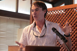
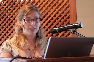
24 May, 2012, HONIARA - The morning of day 4 opened with a presentation on the potentials of Web 2.0 applications and social media for remote collaboration, social development and advocacy by Giacomo Rambaldi.  An highly socio-technologically defining video on Web 2.0 realised by professor Michael Wesch, Kansas University, USA, introduced the main characteristics of Web 2.0 applications, drawing attention to the shift from the old way to understand and use the Web (passive use of somebody else’s content) to the active participation and interaction among users reached today through Web 2.0. Applications such as Wikis, social networks, social bookmarking, on-line mapping, among others, enable the exercise of the “human dimension of technology”, allowing people’s active participation in the production of online content, the sharing of information, the creation of communities of practices and the development and nurturing of networks for social and professional purposes. In the frame of development initiatives, Web 2.0 applications offer powerful and easily accessible platforms that can be used by development actors in diverse contexts and for a range of purposes including disaster risk management, and other climate change related issues.

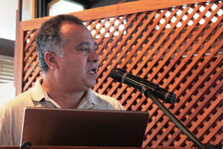
The presentations which followed addressed the integration of traditional and scientific knowledge systems, providing examples of participatory approaches and initiatives carried out in the Solomon Islands and in the Caribbean. In the frame of the development of climate resilient integrated resource management system in Western Solomon, Dr. Simon Albert from Queensland University presented positive examples of how best to incorporate Traditional Ecological Knowledge (TEK) into scientific programmes on marine conservation, while, at the same time, promoting the integration of science into community planning. Among these experiences, the training of community members in monitoring sea level, conducted in 40 provinces, proved to be effective in offering a rapid method for flood risk assessment. Monitoring datasheets were compiled in vernacular language. The initiative actively involved the youth in capturing data, contributing to raising awareness on environmental issues.

Professor Bheshem Ramlal from the University of West Indies (UWI) in Trinidad and Tobago addressed the issue of merging TEK and scientific knowledge in Caribbean, presenting the case of a turtle conservation project. This included training on turtle watching, compilation and dissemination of information on environmental practical strategies and the development of community development plans. The project was successful in integrating local knowledge with scientific tools, increasing the level of awareness and empowering the community.

Both speakers agreed on the fact that TEK provides unique historical, and frequently offers ecosystem linkages that science can not. However, for being based on repetitive observation, trial and error, TEK might have a limited ability to detect and deal with rapid changes, such as those related to the impacts of climate change. Therefore, the need to bridge the gap between local knowledge and science becomes urgent to find sustainable solutions for ecosystem management and adaptation to climate change. If, on the one hand, the incorporation of TEK into scientific tools (such as GIS) can provide an useful platform to document and give value to TEK in contemporary contexts, on the other hand the development of easy-to-use scientific tools for communities can enhance people’s engagement in the conservation activities, increasing their self-resilience, specially in those countries where government capacity is limited.

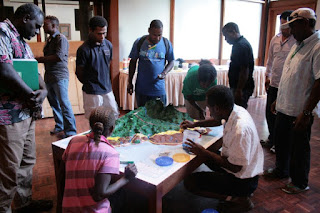
In the meantime villagers had completed the 3D model which accounted for a wealth of information manifest by a total of 39 data layers including 18 area, 6 line and 15 point features.

Joseph Salima from the village of Naro, presented the 3D model to the workshop participants on the behalf of the village representatives: “The model is now done. You can see the blue lines These are rivers; dark blue lines indicate streams”, he explained while finger-pointing to the features. “Some cross the main road because during flooding the water runs over the road. The yellow line indicates the main road. Within the model there are two mountains covered by dense forest where our ancestors used to practice sacrifices.  These are the places were our ancestors lived before the Christianity came. They lived there (upland) because of hunting. The brown lines are the tracks people used to follow during hunting. (…) White areas are flood areas. 
The brown colour signify coconut plantations, that are along the coast. The area outlined by the red yarn  is our Marine Protected Area (MPA)”.  When questioned on the reason why the locally managed protected area is located in front of the village he replied: “Our place is here so we have the full sight on the protected area. We could not establish it elsewhere because people from other villages could have had something to say. We want to protect this area because the population in the village is growing and we are experiencing shortage of resources” he specified. Joseph continued by identifying other landmarks and areas, including home gardens, coconut plantations, households, the school, springs¸, swamps and mangrove areas.“ The area painted dark green with light green points indicates the area were logging took place. The logging concession has come to an end and the forest is recovering. We hunt wild pigs there” he added.

P3D Model gave villagers the opportunity to visualise and further their understand their land and resources “we discovered there are slopes we never saw before that could not be used for agriculture; now with this model we can see them”.

Looking back two days when Joseph and his village mates were standing around the blank model feeling challenged by the task one could clearly see a transformation. He looked confident when presenting all feature on the model. What happened during the process to make this change possible? Joseph was asked. “Filling up the information on the model”, he replied “we could locate yourselves vis-a-vis the map, and we could recognizing the whole model. The 3D model is much more clearer than a topographic map because here we can see the slopes and where the rivers are. It is much more close to reality”, Joseph stressed.

On day 6 the organisers have planned to transport the model to Naro and officially hand it over to the local community. The community itself will decide to what uses it will put it in addition to participatory spatial planning. Considering the fact that the area is prone to natural disasters such as flooding, it is likely that it will be used to also to strategise on climate change adaptation.

“It is my responsibility to get the people together and share with them about this model and its uses. With this model you can easily locate where primary and secondary forest are, where hunting tracks are. With this model we can make decision. This is a live model” Cornelius Nulu concluded.

Villagers stressed the need to further involve elders in the identification of other landmarks and features that they might do not know. “This model is maybe 90% correct; it is quite clear but we needed somebody as my father, or somebody from the village that used to hunt wild pigs everyday for a long time” Joseph highlighted. “If elders were involved in populating the model it is likely that up to 50 layers could have been identified so far” commented Dave de Vera. Village representatives also expressed their intention to extend the model involving other parts of the marine and forest conservation areas.

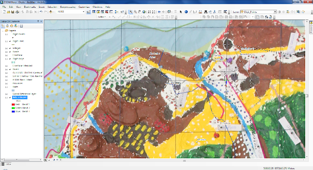
Back to the plenary session, Nate Peterson GIS geek working for TNC, explained how to capture data via digital photography and he provided a practical demonstration of data extraction and geo-referencing, using a high resolution image of the completed 3D Model. He also cross-checked peoples’ data against official datasets and could demonstrate how accurate and precisely geo-located some features entered by community members were.


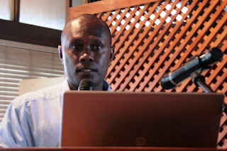
His demonstration was followed by a presentation delivered by Ms. Antonella Piccolella from CTA. She provided clear insights on internal and external factors that may affect participatory mapping processes, in both a positive or negative manners. Ms Piccolella called the attention on the existence of an enabling climate change policy environment for fostering grassroots engagement in climate related decision making processes. The National Adaptation Programme of Action (NAPAs) framework is based on the idea that affected communities should identify the causes of their vulnerability and propose possible solutions. However, she emphasised that to date only few NAPAs explicitly refer to traditional knowledge and grassroots participation and suggested that NAPAs provide definitely an opportunity to look at.

Afterwards, Jimmy Kereseka addressed the use of Information and Communication Technologies (ICTs) for community based planning and information sharing. He provided an overview of participatory tools that can be used for land use and climate change adaptation planning at community, provincial an national level, including participatory mapping and participatory video.

The experience of the Chivoko community in using P3DM and participatory video (PV) was shared by Mr Kiplin, chief of the village. “It is a privilege of be here today on behalf of my community”, he said. “Comparing with other communities, my community was the first in to use P3DM. Two of the main issues we are facing here in Solomon Islands are logging and mining. Mining is recent while logging has been practiced since a long time (…). From a village perspective, making a PV has been a useful experience since it gave us the opportunity to portray a real picture of the logging activities undertaken in our area. In making a video everybody can see the reality of the community” he pointed out.

The last presentation of the day was given by Jonathan Tifiariki, Deputy Director of the National Disaster Management Office. He provided orientation about the National Disaster Management Plan (NDMP) and raised the issue of potential applications for the integration of P3DM practice into NDMP. In this framework, P3DM could be employed to identify high risk areas to include into a Disaster Risk Reduction strategy; the model would help to  best plan tailored solutions for risk reduction, disaster preparedness, disaster response, recovery and rehabilitation. In this sense, the use of P3DM in areas facing climate change challenges could serve not only to generate extra data but to also to strengthen the capacity of the people to respond and adapt to the impacts of climate change, raising awareness on those issues and promote a long-term engagement of the communities to adopt sustainable management practices, fostering participation and the take of responsibilities.

At the end of the day, Giacomo Rambaldi drove the attention on the purpose of the workshop from CTA’s  perspective. The event, in fact, is framed within a broader series of interventions supported by different agencies. All interventions deal with climate change adaptation and building resilience at community levels. CTA focus is on supporting grassroots in making their spatial knowledge more authoritative and in  having their voice heard in climate change adaptation policy development processes. He recalled that the next P3DM activity supported by CTA will be held in Trinidad and Tobago during the months of August 2012.  He anticipated that in 2014, CTA will lead the organisation of an international conference with focus on the Small Islands Development States (SIDS) with the objective of sharing lessons learned in SIDS when adopting PGIS/P3DM practices and herewith raise further awareness among policy makers on the need of inclusiveness.  He also reported on the interest expressed by some organizations including the National Geographic and Museon in documenting P3DM processes.

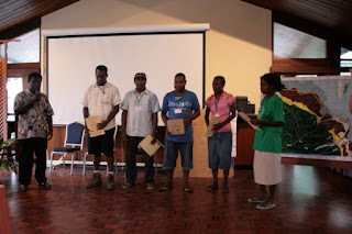
At dawn Jacob Zikuli from UNDP Solomon, thanked the representatives of Naro Village for their contribution in the workshop and confirmed UNDP SWoCK support for the implementation of further activities in the area.

The day closed with the delivery of the certificates to Naro representatives.

Thursday, May 24, 2012

Day 3: Participatory Mapping and Community Empowerment for Climate Change Adaptation, Planning and Advocacy

23 May, 2012, HONIARA - Day 3 started with the visit to the nearby hall where the blank 3D model was on display. At that time six community representatives from Naro location were already working on it taking into account the legend items they previously identified and listed. Assisted by a facilitator they were using colour-coded pushpins, yarns and paint to populate the land-and seascapes of the 3D model. Small labels were used to name settlements, mountain peaks, river courses and other landmark features used by community members to orient themselves in the area. Before start working, the facilitator Patrick Vuet invited Naro representatives to explain the process undertaken so far. “We have been working at the preparation of the legend since yesterday” Joseph Salima from Naro explained. “At the very beginning we experienced some difficulties in recognizing our area on the 3D map. After a short while it became clear to us and now we are able to recognize the entire area. But” he continued “we would like to ask you to help us in case we would not do things properly”.


Looking at the blank model, he seemed challenged by the task and not confident about his capabilities.
However, when the workshop participants asked Joseph to identify the location of the Naro village and the protected marine area, he did not hesitate and pointed his finger to specific locations on the blank 3D model. The immediate response of Joseph was the demonstration of what the workshop participants had learned during the previous days, namely that deeply rooted knowledge needs the right channel to surface. In fact Participatory 3D Modelling (P3DM) is known for facilitating reflection and for eliciting tacit knowledge, and for making people aware of the precious knowledge they hold.
While community representatives started populating the model with coloured yarns and pushpins, in the main hall Giacomo Rambaldi opened the morning session addressing the main topic of the day: attitudes, behaviours and ethics in practicing participatory GIS (PGIS). By running a map reversal exercise and showing images focusing on body language, Rambaldi argued that external factors influence our beliefs, values and attitudes. In turn the latter manifest through our behaviours and affect our facilitation work among rural communities. Indeed, acceptable behaviours and ethics can vary from culture to culture. To highlight this aspect, Dave de Vera and Senoveva Mauli facilitated a group exercise focusing on the definition of ground rules for community workers or technology intermediaries entering a community.

Five working group were formed based on the geographical origin of the participants. Although the final outputs differed based on cultural traits and target beneficiaries, some crosscutting elements could be singled out. These included (i) the need for building a trustful relationship, (ii) being open and transparent on intended and possibly unintended consequences, (iii) the need for obtaining free, prior, informed consent (FPIC) from participating knowledge holders on data capturing and handling, (iv) the need for ensuring respect of intellectual property rights (IPR) and (v) the need for involving local authorities and community leaders from the very early stages of the process.

Following the projection of the inspiring video “Localisation, participation and communication: an introduction to good PGIS practice” where the main does and don’ts in the facilitation of participatory mapping processes are addressed, Giulia Pedone interviewed a panel of experts on attitude, behaviours and ethics in the context of community-based activities. Jacob Zikuli, Adaptation Fund SWoCK Project Manager; Simon Albert, researcher at the University of Queensland; Neila Bobb-Prescott, Senior Technical Officer for the Caribbean Natural Resource Institute (CANARI) and Dave de Vera, PAFID Executive Director, composed the panel.

Jackob Zikuli was invited to comment about good practices for building trust between intermediaries and community. “Building trust is a very important part of the work” he said. “I follow four principles: first, introduce your work to the community, to build confidence. Second, be honest and clear about what you do and about the implications of your work. Third, you have to be careful with the benefits people might expect from your work (don’t raise false expectations); only when people evaluate benefits and risks they can be able to say “yes” or “no”. And forth, a long term commitment with communities, showing that your work will build capacities and strengthen them”.

The sensitive issue of intellectual ownership of knowledge holders on the information provided during scientific research was raised with Simon Albert. “This is a very sensitive issue I have been confronting with several times while working in Melanesia.  It is important to ensure equal access to information and get Free, Prior and Informed Consent from the knowledge holders before making use of the collected data” he said. However “the real key issues are the human behaviour and the internal attributes of the person” Simon Albert added. This relates with integrity and sensitiveness of the researcher. Indeed, some recommendation can be also drawn: the establishment of a long-term, strong bond and friendly relationship with communities, the use of local language to ensure mutual understanding among parties and avoid miscommunication and a deep comprehension of the cultural context; all are key elements that can facilitate a trusted relationship between researchers and communities, and that should mitigate risks of misappropriation of local knowledge.

Neila Bobb-Prescott presented some participatory tools she uses in her work with communities in the Caribbean to facilitate participatory processes. Tools like the stakeholder analysis can identify who should be involved in the process, at what stage and taking which responsibilities. This exercise should be done at the very early stage of the process in order to ensure fair participation of community members and avoid that few people take control over it. In addition, according to Ms. Bob-Prescott, the presence of a skilled, independent facilitator is also crucial for promoting equal participation.

How to ensure that people are aware of the potential consequences of undertaking participatory processes and how to avoid to expose people to danger, especially when working in conflict areas, was the question addressed to Dave de Vera. “In my experience, people that choose to get involved in participatory processes, especially mapping,  are already aware of the risks”, he replied.  Participatory mapping processes may touch on sensitive issues but might also be used to address conflicts. The role of the facilitator is to provide an even basis of understanding spatial issues upon which to build and elaborate diverse scenarios, be honest about opportunities and risks, and enable community members to take informed decisions.  “90% of facilitation is about sensitivity”, he added. “It is like having a third eye, able to read between lines, being sensitive to the circumstances”, independently from the educational background the person has.

The last questions addressed to all panellists focused on “who gains and who loses” and “who is empowered or disempowered” within participatory processes. “If not done properly” Dave de Vera replied, “everybody loses. The facilitator will loose his/her credibility. At the same time the community will also loose because it will be misrepresented. On the contrary, if done properly, both sides would win. Facilitators learn, and the community gains. I have been involved in participatory mapping during the last 20 years and I am still learning. Every P3DM is something new; I always learn from people”, he concluded.

The panel was followed by a Q&A session which generated a vibrant debate about those sensitive issues.

The panel was followed by a presentation of Neila Bobb-Prescott on facilitating grassroots participation in decision making processes in the Caribbean. She kick-started her slot animating an energising game among participants. The game helped raising awareness on key factors that influence participatory processes, such as the spontaneous emergence of group leaders in crisis situations, the diversity of power relations within groups, and the need to strategize and foster collaboration to address complex situations. In line with the core thrust of the workshop, Neila Bobb-Prescott presented two case study: The first one was on the formulation of Trinidad and Tobago forest and protected areas policies through collaborative processes. The second one focused on participatory video used as an advocacy tool to help a fishing community communicate their challenges and develop partnerships to address them. According to Neila, in both cases the deployment of trained, independent facilitators emerged as a key success factor. This could help building trust and understanding of issues among the parties. Communities need to develop clear messages to communicate their needs. Use participatory tools to plan how communities will be engaged and what role you want them to play so it is clear what participants from the community are expected to do. Involve communities and their intermediaries in policy development to build support, capacity and interest in management.

The last part of the day was dedicated to participatory video as tool for community empowerment and advocacy.

Video, in fact, allows communities to express their vision from their own perspective, document their stories and traditions, communicate and raise awareness about the main challenges they are facing and share their experiences.
Kat Gawlik, a freelance media producer attending the workshop on behalf of TNC, described how in participatory processes, multimedia can be used for enabling marginalised people to speak out, raise concerns and gain public attention.

One of the videos produced by coastal communities in the framework of a TNC-supported initiative in the Solomon Islands provides evidence on climate change impacts and documents how affected communities had planned to best manage their environment.

During the course of the whole day, community representatives from Naro worked towards the completion of their 3D model.

Primary and secondary forest, coconut plantations, coastal protected areas, swamps, river courses, roads, logging concessions’ boundaries and other landmarks gradually populated the map.


An initiative supported by:
Read more: