Puerto Princesa - ALDAW. On the 7th of June (
see IC release) 600 protesters from farmers and indigenous communities reached the capital city of Puerto Princesa on Palawan Island requesting the Provincial Government not to endorse the proposed mining plans of MacroAsia and Ipilan Nickel Corporation (INC). As a result of the negotiations taking place between the protesters’ delegation and policy makers in Puerto Princesa, the Provincial Government agreed that endorsement of both MacroAsia and INC should have required further investigation. However, that promise was not honoured and, after a few days, the Provincial Government gave his endorsement to MAC and INC to operate in one of the best conserved biocultural paradises found in the Philippines, and in South-East Asia as a whole.
The area given out to mining concession is also inhabited by traditional indigenous Palawan having limited contacts with the outside world. Moreover, the Gantong range and neighboring areas where MAC and INC intend to operate are within the area recently declared as Mount Mantalingahan Protected Landscape, pursuant to Presidential Proclamation no. 1815.
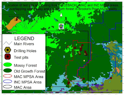 |
Location of test pits and drilling holes within the mining concessions and
their overlap with mossy and old growth forest in Brook's Point Municipality |
Both the MPSA areas of MacroAsia and INC are located in ecologically valuable areas which include watersheds, hunting/ agricultural grounds, extractive reserves of Non-Timber Forest Products (NTFPs) such as Almaciga (Agathis philippinensis) resin, on which upland indigenous communities depend for their daily subsistence. Also indigenous peoples’ sacred and worship sites are found within the mining tenements of these companies.
Representatives of ELAC (Environmental Legal Assistance Center) are now filing cases against government officials and their respective agencies for having endorsed MAC and INC without securing first the needed social acceptability requirements and in disregard of the Strategic Environmental Plan (Republic Act 7611).
Say ELAC Atty. Edward G. Lorenzo: “the sustainable management of the entire Province is, in fact, governed by the SEP law which prohibits any human activity in those areas that are classified as ‘core zones’ and that – very unfortunately - are now part of MAC and INC mining tenements”. A indigenous member of the indigenous community of Gieb (Barangay Maasin, Brooke’s Point Municipality) also claims: “they (mining personnel of MAC) just entered our land without asking permission, and they removed our rice plants to excavate big ditches in our agricultural fields and also up into the mountains, only few meters away from the Balgtik (Agathis Philippinensis) trees that we sell and from which we depend for our survival”. According to another member of the same community: “MacroAsia peoples have removed soil and trees also in those sacred forest that we call lylien and that are inhabited by powerful super-human beings (Taw Kawasa)”.
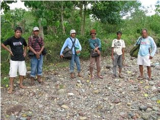
Between 12-16 July a geotagging field reconnaissance carried out by the ALDAW (Ancestral/Land Domain Watch) in collaboration with the Centre for Biocultural Diversity (
CBCD) of the University of Kent has confirmed that MacroAsia test pits and drilling holes are found in ‘core zones’ (areas of maximum protection) around and even above 1,000 m ASL. Indigenous peoples trained on basic GPS and Geotagging technologies, with their own set of equipment divided into two groups to cover a large portion of the MAC and INC mining tenement area.
It appears that both MAC and INC have violated the basic tenets of the Strategic Environmental Plan (SEC) and also of the Indigenous Peoples Rights Act (
IPRA Law), a national law protecting the interests of Indigenous Cultural Communities (ICC). Faced by this and similar accusations, the Provincial Government recently made a statement according to which MacroAsia and INC may not be allowed to operate in core zones, but their activities might be limited only to multiple/manipulative use areas. Again, ocular inspection and GPS data obtained by ALDAW and CBCD indicate the those portions of MacroAsia and INC mining concessions, which are outside the core zones, still include forested buffer zones which, obviously, do not fit by any means into the standard definition of ‘multiple/manipulative use zones’, where – according to the law – mining might be allowed. In fact, the mining claims of both MAC and INC are entirely located in ‘core zones’, ‘restricted zones’, agricultural and agroforestry areas that are subject to various cropping regimes. All these categories, according to the SEP law, should not be subject to any other form of large-scale extractive activity.
Also, lowland farmers are extremely concerned about the siltation of their wet-rice cultivation, as all irrigation water coming into their fields originates from the mountains where mining is supposed to take place. Members of academic institutions have suggested that: unless these precious water catchments are protected from mining operations, at least 50% of Brooke’s point sustainable agriculture, which requires irrigation, might be lost.
Says a spokesman of
Alyansa Tigil Mina (the largest anti-mining advocacy group in the country) “Ironically enough the mining companies and the politicians who are endorsing them have also infringed the Philippine Mining Act which prohibits mining in old growth or virgin forest, proclaimed watershed forest reserves, wilderness area, and other areas of outstanding environmental value”. According to Atty. Mary Jean Feliciano of the ALDAW Network “in endorsing the mining exploration of both MAC and INC, the Sangguniang Bayan (Local Government of Brooke’s Point) has acted in contradiction with its own Municipal Comprehensive Land Use Plan (CLUP) for 2000-2010, in which mining was never considered as a development strategy and, in doing so, it has also bypassed the interests of local communities, as well as all forms of public consultations”.
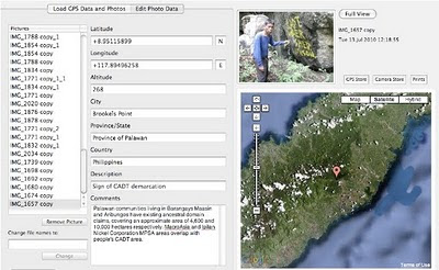 |
| Cornerstone of a CADT (Certificate of Ancestral Domain Title) |
Undoubtedly, the endorsement by both Local and Provincial governments of the proposed operations of MAC and INC contravenes also those provisions contained in well know conventions [e.g. The Convention on Biological Diversity (CBD) and the UN Declaration on the Rights of Indigenous Peoples that the Philippine Government has already signed. Says a member of the Palawan advocacy community: “When the Government itself infringes its own laws so bluntly, it means that the fundamentals of democracy are breaking apart and a new form of state-led terrorism is coming into being to deprive hundreds of farmers and indigenous peoples of their traditional, and thus legitimate sources of life, just to benefit a handful of greedy and irresponsible businessmen and their cronies”.
On
July 30, 2010 the members of the Palawan Council for Sustainable Development (
PCSD) - a local government body in charge of the protection and sustainable management of the province - will meet to decide whether to issue a SEP clearance to the operations of MacroAsia and Ipilan Nickel Corporations. The future of one of the most pristine forests in the Philippines and the life of thousands of peoples who depend from it, is now in the hands of the Council.
Indigenous peoples and their networks, farmers, fisher folks, the Palawan NGO Network Inc (PNNI) and its associates, are uniting their effort to convince the PCSD to take a responsible decision which will ensure the sustainable future of Brook’s Point Municipality and of its biocultural diversity.
What you can do ...
Sign a
Petition to Stop Mining in Palawan!
And address your concerns to:
Palawan Council for Sustainable Development
oed@pcsd.ph . and c/o Mearl Hilario
mearlhilario@yahoo.com
FAX: 0063 (048) 434-4234
Honorable Governor of Palawan
Baham Mitra
abmitra2001@yahoo.com
FAX: 0063 (048) 433-2948
For more information watch
ALDAW videos
http://www.vimeo.com/aldawnetwork
http://www.youtube.com/user/ALDAWpalawan
http://hub.witness.org/en/users/aldaw-network
or contact the ALDAW Network (Ancestral Land/Domain Watch)
aldawnetwork@gmail.com and Alyansa Tigil Mina (
nc@alyansatigilmina.net /
alyansatigilmina@gmail.com )