Friday, July 30, 2010

Participatory 3D Modelling used for the development of a community conserved area management plan in Mexico

Maps like this one will help the communties to
have a better understanding of resources
when developing their management plans;
Photo: Irma Juan Carlos
Oaxaca, Mexico: From March until May 2010, three university students from Chile and Mexico supported the ongoing work of Chinantec research teams to develop a management plan for their community conserved areas.

Andrés Basante, a master's student from the Environmental Geography Research Center of the National Autonomous University of Mexico (CIGA - UNAM), led a series of community mapping workshops.
Tomás Ibarra, a master's student at the University of Kent, conducted fieldwork for his dissertation on the influence of a hunting moratorium on socio-cultural change in the Chinantla.
Antonia Barreau worked as a research collaborator to conduct a short study entitled “Effects of conservation activities on diet patterns in Chinantec communities”.
These results will be returned to the communities to be integrated into their management programs.

by Claudia Camacho
Mesoamerica Coordinator

Source: Global Diversity Foundation Update; Issue 4, July 2010

Thursday, July 29, 2010

Recreando nuestra Cultura, Mapeando nuestro Futuro


El cuento de un encuentro especial en Venda, Sur Africa, y un proceso comunitario de cartografía eco-cultural. Líderes indígenas del Altai (Rusia) y la Amazonía Colombiana, juntos con representantes de ONGs de Sur Africa, Kenia y Etiopía, acompañan a la comunidad de Tshidvizhe mientras que descubren una sencilla pero poderosa manera de expresar el pasado y el presente de su territorio  en mapas hechos a mano. Los mapas destacan la importancia de su cultura, los sitios sagrados, el territorio y sus modos de vida, y empoderan a la comunidad mapear el futuro por lo cual deben luchar.

Tuesday, July 27, 2010

Palawan ‘UNESCO Man and Biosphere Reserve’ in the grip of Mining Companies?

Puerto Princesa - ALDAW. On the 7th of June (see IC release) 600 protesters from farmers and indigenous communities reached the capital city of Puerto Princesa on Palawan Island requesting the Provincial Government not to endorse the proposed mining plans of MacroAsia and Ipilan Nickel Corporation (INC). As a result of the negotiations taking place between the protesters’ delegation and policy makers in Puerto Princesa, the Provincial Government agreed that endorsement of both MacroAsia and INC should have required further investigation. However, that promise was not honoured and, after a few days, the Provincial Government gave his endorsement to MAC and INC to operate in one of the best conserved biocultural paradises found in the Philippines, and in South-East Asia as a whole.

The area given out to mining concession is also inhabited by traditional indigenous Palawan having limited contacts with the outside world. Moreover, the Gantong range and neighboring areas where MAC and INC intend to operate are within the area recently declared as Mount Mantalingahan Protected Landscape, pursuant to Presidential Proclamation no. 1815.
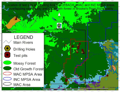
Location of test pits and drilling holes within the mining concessions and
their overlap with mossy and old growth forest in Brook's Point Municipality
Both the MPSA areas of MacroAsia and INC are located in ecologically valuable areas which include watersheds, hunting/ agricultural grounds, extractive reserves of Non-Timber Forest Products (NTFPs) such as Almaciga (Agathis philippinensis) resin, on which upland indigenous communities depend for their daily subsistence. Also indigenous peoples’ sacred and worship sites are found within the mining tenements of these companies.

Representatives of ELAC (Environmental Legal Assistance Center) are now filing cases against government officials and their respective agencies for having endorsed MAC and INC without securing first the needed social acceptability requirements and in disregard of the Strategic Environmental Plan (Republic Act 7611).

Say ELAC Atty. Edward G. Lorenzo: “the sustainable management of the entire Province is, in fact, governed by the SEP law which prohibits any human activity in those areas that are classified as ‘core zones’ and that – very unfortunately - are now part of MAC and INC mining tenements”. A indigenous member of the indigenous community of Gieb (Barangay Maasin, Brooke’s Point Municipality) also claims: “they (mining personnel of MAC) just entered our land without asking permission, and they removed our rice plants to excavate big ditches in our agricultural fields and also up into the mountains, only few meters away from the Balgtik (Agathis Philippinensis) trees that we sell and from which we depend for our survival”. According to another member of the same community: “MacroAsia peoples have removed soil and trees also in those sacred forest that we call lylien and that are inhabited by powerful super-human beings (Taw Kawasa)”.
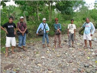
Between 12-16 July a geotagging field reconnaissance carried out by the ALDAW (Ancestral/Land Domain Watch) in collaboration with the Centre for Biocultural Diversity (CBCD) of the University of Kent has confirmed that MacroAsia test pits and drilling holes are found in ‘core zones’ (areas of maximum protection) around and even above 1,000 m ASL. Indigenous peoples trained on basic GPS and Geotagging technologies, with their own set of equipment divided into two groups to cover a large portion of the MAC and INC mining tenement area.

It appears that both MAC and INC have violated the basic tenets of the Strategic Environmental Plan (SEC) and also of the Indigenous Peoples Rights Act (IPRA Law), a national law protecting the interests of Indigenous Cultural Communities (ICC). Faced by this and similar accusations, the Provincial Government recently made a statement according to which MacroAsia and INC may not be allowed to operate in core zones, but their activities might be limited only to multiple/manipulative use areas. Again, ocular inspection and GPS data obtained by ALDAW and CBCD indicate the those portions of MacroAsia and INC mining concessions, which are outside the core zones, still include forested buffer zones which, obviously, do not fit by any means into the standard definition of ‘multiple/manipulative use zones’, where – according to the law – mining might be allowed. In fact, the mining claims of both MAC and INC are entirely located in ‘core zones’, ‘restricted zones’, agricultural and agroforestry areas that are subject to various cropping regimes. All these categories, according to the SEP law, should not be subject to any other form of large-scale extractive activity.

Also, lowland farmers are extremely concerned about the siltation of their wet-rice cultivation, as all irrigation water coming into their fields originates from the mountains where mining is supposed to take place. Members of academic institutions have suggested that: unless these precious water catchments are protected from mining operations, at least 50% of Brooke’s point sustainable agriculture, which requires irrigation, might be lost.

Says a spokesman of Alyansa Tigil Mina (the largest anti-mining advocacy group in the country) “Ironically enough the mining companies and the politicians who are endorsing them have also infringed the Philippine Mining Act which prohibits mining in old growth or virgin forest, proclaimed watershed forest reserves, wilderness area, and other areas of outstanding environmental value”. According to Atty. Mary Jean Feliciano of the ALDAW Network “in endorsing the mining exploration of both MAC and INC, the Sangguniang Bayan (Local Government of Brooke’s Point) has acted in contradiction with its own Municipal Comprehensive Land Use Plan (CLUP) for 2000-2010, in which mining was never considered as a development strategy and, in doing so, it has also bypassed the interests of local communities, as well as all forms of public consultations”.
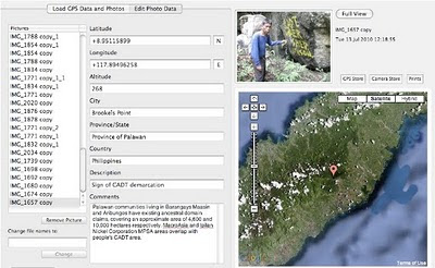
Cornerstone of a CADT (Certificate of Ancestral Domain Title)

Undoubtedly, the endorsement by both Local and Provincial governments of the proposed operations of MAC and INC contravenes also those provisions contained in well know conventions [e.g. The Convention on Biological Diversity (CBD) and the UN Declaration on the Rights of Indigenous Peoples that the Philippine Government has already signed. Says a member of the Palawan advocacy community: “When the Government itself infringes its own laws so bluntly, it means that the fundamentals of democracy are breaking apart and a new form of state-led terrorism is coming into being to deprive hundreds of farmers and indigenous peoples of their traditional, and thus legitimate sources of life, just to benefit a handful of greedy and irresponsible businessmen and their cronies”.

On July 30, 2010 the members of the Palawan Council for Sustainable Development (PCSD) - a local government body in charge of the protection and sustainable management of the province - will meet to decide whether to issue a SEP clearance to the operations of MacroAsia and Ipilan Nickel Corporations. The future of one of the most pristine forests in the Philippines and the life of thousands of peoples who depend from it, is now in the hands of the Council.

Indigenous peoples and their networks, farmers, fisher folks, the Palawan NGO Network Inc (PNNI) and its associates, are uniting their effort to convince the PCSD to take a responsible decision which will ensure the sustainable future of Brook’s Point Municipality and of its biocultural diversity.


What you can do ...

Sign a Petition to Stop Mining in Palawan!


And address your concerns to:

Palawan Council for Sustainable Development
oed@pcsd.ph . and c/o Mearl Hilario mearlhilario@yahoo.com
FAX: 0063 (048) 434-4234

Honorable Governor of Palawan
Baham Mitra
abmitra2001@yahoo.com
FAX: 0063 (048) 433-2948

For more information watch ALDAW videos
http://www.vimeo.com/aldawnetwork
http://www.youtube.com/user/ALDAWpalawan
http://hub.witness.org/en/users/aldaw-network
or contact the ALDAW Network (Ancestral Land/Domain Watch) aldawnetwork@gmail.com  and Alyansa Tigil Mina (nc@alyansatigilmina.net / alyansatigilmina@gmail.com )

Friday, July 23, 2010

Le projet de cartographie participative dans le Bassin du Congo

Freddy Nguema Allogo est responsable technique du projet cartographie participative dans le Bassin du Congo par compte de Brainforest Gabon. Freddy décrives le projet et son état d’avancement.


Le projet régional de cartographie participative dans le Bassin du Congo pour la République du Congo a été lancé le 18 juin à Brazzaville. Initié par la Rainforest Foundation du Royaume Uni, ce projet qui s’étalera sur deux ans, sera mis en œuvre par l’Observatoire congolais des droits de l’homme (OCDH).

L’objectif global de la cartographie participative dans le Bassin du Congo est de promouvoir l’inclusion des droits des communautés forestières pour un contrôle et une utilisation rationnelle des forêts.

Le projet vise à renforcer les capacités des communautés forestières, de l’administration et des organisations de la société civile à mieux connaître les ressources forestières ; à soutenir les communautés forestières dans leur dialogue avec les autorités compétentes.

L’initiative de Rainforest Foundation traduit la volonté du Gouvernement anglais de ralentir le processus de déforestation par le développement des capacités des populations et des institutions des pays du Bassin du Congo dans la gestion durable des forêts, tout en assurant les meilleures conditions de vie aux communautés locales.

Ainsi, ces cartes géo référencées, une fois produites, devront mettre en valeur la richesse des écosystèmes forestiers du Congo et souligner les dimensions économiques, sociales et culturelles qu’ils représentent pour les populations qui y vivent

Tuesday, July 06, 2010

High resolution participatory satellite imagery interpretation in Southern Etiopia


A SPOT 5 scene was used to explore indigenous land use patterns, pastoral rangeland management and infrastructures with Borana pastoralist, a customary institution in Oromia region, Southern Ethiopia. Video material produced in August 2009. Contribution: Massimiliano Rossi

Sunday, June 13, 2010

RROMUEPATSRO: Mapping the Historical-Cultural Space of the Yanesha, Perú


This video is the first in a series titled “Where Our Ancestors Walked: Mapping the Historical-Cultural Space of the Yanesha People,” which was made in collaboration with the Yanesha people in order to preserve their history and its relation with their territory as sacred landscape. Rromuepatsro presents the Yanesha people, located in the eastern slope of the Peruvian central Andes, and explores their vital relationship with their ancestors and the natural landscape. It shows how they have used PGIS, anthropological research and Yanesha oral history to map their historical cultural space and thus reaffirm their millennial link to the ancient world and the civilization of the central Andes.

This video has been produced in Spanish and English by the Instituto del Bien Común (IBC), Lima, Perú.

Wednesday, June 09, 2010

Reviving our culture, Mapping our future


The story of a special gathering in Venda, South Africa, and a community process in eco-cultural mapping. Indigenous leaders from Altai (Russia) and the Colombian Amazon, and NGO representatives from South Africa, Kenya and Ethiopia, accompany Tshidvizhe community as they explore a simple yet powerful way to express the past and present of their territory and livelihoods onto hand-drawn maps. The maps highlight the importance of their culture, sacred sites and territory, and empower them to map the future they need to strive for.

Production: The Gaia Foundation, African Biodiversity Network (ABN), Mupo Foundation and the Technical Centre for Agricultural and Rural Co-operation ACP-EU (CTA).

Friday, June 04, 2010

Participatory mapping at IFAD

The International Fund for Agricultural Development (IFAD) is implementing the project “Piloting IFAD’s Participatory Mapping Approach for Specific Livelihoods” through innovative twinning arrangements.

The second phase of the project has focused on participatory mapping. As a result IFAD published “Good Practices in Participatory Mapping” and the “IFAD Adaptive Approach to Participatory Mapping”.

The next phase is focusing is participatory monitoring and evaluation of participatory mapping processes.

Below are the main outcomes of the second phase:
  • The International Fund for Agricultural Development (Corbett J. M.) (2009) “ Good practices in participatory mapping.” The International Fund for Agricultural Development, Rome, Italy. 55 pages.

Tuesday, June 01, 2010

Whose Map? | ¿De Quién Son Los Mapas? | à qui appartiennent les cartes ? English / français/ español

In recent years, changes in participatory methodologies (PMs) may have been even more rapid than those in spatial technologies. Local people's abilities to make maps only became widely known and facilitated in the early 1990s. In this article Dr. Robert Chambers argues that participatory mapping has spread like a pandemic with many variants and applications not only in natural resource management but also in many other domains. With mapping as one element, there are now signs of a new pluralist eclecticism and creativity in PMs. The medium and means of mapping, whether ground, paper or GIS and the style and mode of facilitation, influence who takes part, the nature of outcomes and power relationships. Much depends on the behaviour and attitudes of facilitators and who controls the process. Many ethical issues present troubling dilemmas, and lead to overarching questions about empowerment and ownership. Questions to be asked, again and again, are: Who is empowered and who disempowered? And, who gains and who loses?

Below is the original article published on  EJISDC, an open access journal, and translations in French and Spanish done in the context of the development of the "Training Kit on Participatory Spatial Information Managamant and Communication" soon to be published by CTA and IFAD.
Here is a related interview with Robert Chambers subtitled in 10 languages (you can embed this video on your blog or web site!)

Sunday, May 30, 2010

Participatory Spatial Information Management and Communication in Developing Countries / English / Français / Español

The merging of participatory development methods with geo-spatial technologies has come to be known as Participatory GIS and is now an emergent development practice in its own right. PGIS combines a range of geo-spatial information  management  tools and methods such as sketch maps, participatory 3D models, community-based air photo and satellite imagery interpretation, GPS transect walks and GIS-based cognitive mapping. Participatory GIS implies making GIT&S available to disadvantaged groups in society in order to enhance their capacity in generating, managing, analysing and communicating spatial information.

PGIS practice is geared towards community empowerment through measured, demand-driven, user-friendly and integrated applications of geo-spatial technologies. GIS-based maps and spatial analysis thus become major conduits in the process. A good PGIS practice is embedded into long-lasting and locally driven spatial decision-making processes, is flexible, adapts to different socio-cultural and bio-physical environments, depends on multidisciplinary facilitation and skills and builds essentially on visual language. If appropriately utilized, the practice should exert profound impacts on community empowerment, innovation and social change. More importantly, by placing control of access and use of culturally sensitive spatial information in the hands of those who generated them, PGIS practice can protect traditional knowledge and wisdom from external exploitation.

Effective participation is the key to good PGIS practice. Whilst the focus of traditional GIS applications is often on the outcome, PGIS initiatives tend to emphasize the processes by which outcomes are attained. At times the participatory process can obfuscate systematic inequalities through unequal and superficial participation. For example, PGIS applications may be used to legitimise decisions which in fact were taken by outsiders. The process can also easily be hijacked by community elites. For PGIS practices to be successful, they must be placed in a well thought out and demand-driven process based on the proactive collaboration of the custodians of local and traditional knowledge and of facilitators skilled in applying PGIS and transferring technical know-how to local actors. Participation thus cuts across the process from gaining a clear understanding of the existing legal and regulatory frameworks, to jointly setting project objectives, defining strategies and choosing appropriate geo-spatial information management tools. The integrated and multifaceted nature of PGIS provides legitimacy for local knowledge and generates a great sense of confidence and pride which prepares participant communities in dealing with outsiders. The process is intended to build self-esteem, raise awareness about pressing issues in the community and produce concrete and sustainable spatial solutions.

Below is the original article published on  EJISDC, an open access journal, and translations in French and Spanish done in the context of the development of the "Training Kit on Participatory Spatial Information Managamant and Communication" soon to be published by CTA and IFAD.
A vast freely accessible digital library is available at http://www.iapad.org/bibliography.htm
Selected publications on the subject are available at www.gis4d.com

Thursday, May 27, 2010

PPgis.net Open Forum on Participatory Geographic Information Systems and Technologies


PPgis.net serves as a global avenue for discussing issues, sharing experiences and good practices related to community mapping, public participation GIS (PPGIS), participatory GIS (PGIS) and other geographic information technologies used to support integrated conservation and development, sustainable natural resource management and customary property rights in developing countries and among indigenous people worldwide. 
Members of the network are able to share information and lessons learned, post questions and announcements and upload and download resource documents which are relevant to the practice. 
 
The site is an online gateway for accessing discussion lists in English, French, Spanish and Portuguese, all dealing with participatory mapping.

Monday, May 24, 2010

Mapping Indigenous Lands / Mapeo de tierras indígenas / Cartographier les territoires autochtones

We have just completed the translation of this important publication by Mac Chapin & colleagues.
Here are the links to the documents.
  • Mac Chapin, Zachary Lamb, and Bill Threlkeld. Mapping Indigenous Lands. Annual Review of Anthropology 34 (2005) : 619-639
  • Mac Chapin, Zachary Lamb, and Bill Threlkeld. Mapeo de tierras indígenas. Annual Review of Anthropology 34 (2005) : 619-639 - Traducido y publicado por el Centro Técnico de Cooperación Agrícola y Rural (CTA), con autorización de ―Annual Review of Anthropology‖
  • Mac Chapin, Zachary Lamb, and Bill Threlkeld. Cartographier les territoires autochtones. Annual Review of Anthropology 34 (2005) : 619-639 - Traduit et publié par le Centre Technique de Coopération Agricole et Rurale (CTA) avec la permission de « Annual Review of Anthropology »

Monday, May 17, 2010

Participatory Action Research Approaches and Methods: Connecting People, Participation and Place

Participatory Action Research (PAR) approaches and methods have seen an explosion of recent interest in the social and environmental sciences. PAR involves collaborative research, education and action which is oriented towards social change, representing a major epistemological challenge to mainstream research traditions. It has recently been the subject of heated critique and debate and rapid theoretical and methodological development.

This book captures these developments, exploring the justification, theorisation, practice and implications of PAR. It offers a critical introduction to understanding and working with PAR in different social, spatial and institutional contexts. The authors engage with PAR’s radical potential, while maintaining a critical awareness of its challenges and dangers. The book is divided into three parts. The first part explores the intellectual, ethical and pragmatic contexts of PAR; the development and diversity of approaches to PAR; recent poststructuralist perspectives on PAR as a form of power; the ethic of participation; and issues of safety and well-being. Part two is a critical exploration of the politics, places and practices of PAR. Contributors draw on diverse research experiences with differently situated groups and issues including environmentally sustainable practices, family livelihoods, sexual health, gendered experiences of employment, and specific communities such as people with disabilities, migrant groups, and young people. The principles, dilemmas and strategies associated with participatory approaches and methods including diagramming, cartographies, art, theatre, photovoice, video and geographical information systems are also discussed. Part three reflects on how effective PAR is, including the analysis of its products and processes, participatory learning, representation and dissemination, institutional benefits and challenges, and working between research, action, activism and change.

The authors find that a spatial perspective and an attention to scale offer helpful means of negotiating the potentials and paradoxes of PAR. This approach responds to critiques of PAR by highlighting how the spatial politics of practising participation can be mobilised to create more effective and just research processes and outcomes. The book adds significant weight to the recent critical reappraisal of PAR, suggesting why, when, where and how we might take forward PAR’s commitment to enabling collaborative social transformation. It will be particularly useful to researchers and students of Human Geography, Development Studies and Sociology.

Sunday, May 16, 2010

Choosing a participatory mapping method versus another

PGIS practitioners make use of a range of low and high tech geographic information technologies for acquisition, validation, analysis, representation and sharing of geo-spatial information. There are a number of factors that influence the choice of one method over another or the combination of more than one method. Factors include the ‘purpose behind the initiative’, the ‘resources available’ and the ‘institutional setting or environment’.
The choice of method should emanate predominantly from within the community . Participatory maps often represent a socially or culturally distinct understanding of land and seascapes and include information that is excluded from mainstream maps. These usually represent the views of the dominant sectors of society. Participatory maps can pose alternatives to the languages and images of the existing power structures and become a medium of empowerment by allowing local communities to represent themselves spatially.

For this reason, participatory maps should be made through an inclusive process at community level. The higher the level of participation by all members of the community, the more beneficial the outcome because the final maps, and related outputs like multimedia, will reflect the collective knowledge, concerns and aspirations.

In September 2010, CTA and IFAD will launch a Training Kit dedicated to “Participatory Spatial Information Management and Communication” and having the specific objective of supporting the spread of good practice in generating, managing, analysing and communicating spatial information. More information on the training kit will be made available on the Internet and on this blog.

Wednesday, May 12, 2010

Participatory Video Validates Geo-Tagging Evidences on Mining Threats to Palawan Ecology and Indigenous Livelihoods

A field update from the ALDAW Network (Ancestral Land/Domain Watch)
May 2010

Between July and September 2009, a mission organized by the Philippines-based Ancestral Land/Domain Watch (ALDAW) and the Centre for Biocultural Diversity (CBCD) at the University of Kent demonstrated how the ecological balance and the survival of vulnerable indigenous communities on Palawan Island (a “Man and Biosphere Reserve” program of UNESCO) is being threatened by the ongoing mining rush. The mission’s actual ‘matching’ of collected GPS data to photographs shows that the Mineral Production Sharing Agreements (MPSA) of mining firms, such as MacroAsia and Rio Tuba Nickel Mining Corporations, overlap with precious watersheds and the so called “core zones” of maximum protection. During the mission indigenous communities were engaged in the making and editing of participatory videos.


Today the voices of these isolated Palawan communities are available through the following links:

http://www.youtube.com/user/ALDAWpalawan
http://vimeo.com/aldawnetwork

Wednesday, April 28, 2010

ILO Convention on indigenous and tribal peoples: a manual

This is an easy-to-use manual to ILO Convention No. 169. It helps to understand the Convention, and how it can be used to gain recognition, promotion and protection of indigenous and tribal peoples' rights.
The manual - dated 2003 - does not explain each article of the Convention. It focuses on key concepts such as, for example, human rights, culture,land, development, education and health.
Nor does it strictly follow the structure of the Convention. It is divided into different sections. Each section deals with a key concept.
For easy reference, the manual has included the article or articles of the Convention which are being discussed. There is a descriptive explanation of each article. Concepts are introduced by using examples and experiences from indigenous and tribal peoples. This is to demonstrate the articles of the Convention in a practical way. ILO also included diagrams and photographs which highlight and explain some important elements of the articles.

Wednesday, April 21, 2010

Rethinking the Power of Maps

A contemporary follow-up to the bestselling Power of Maps, this book takes a fresh look at what maps do, whose interests they serve, and how they can be used in surprising, creative, and radical ways.

In Rethinking the Power of Maps, Denis Wood describes how cartography facilitated the rise of the modern state and how maps continue to embody and project the interests of their creators. He demystifies the hidden assumptions of map making and explores the promises and limitations of diverse counter-mapping practices today.

Thought-provoking illustrations include U.S. Geological Survey maps; electoral and transportation maps; and numerous examples of critical cartography, participatory GIS, and map art.

Wednesday, March 24, 2010

Power of Maps: (Counter) Mapping for Conservation

This paper considers what is at stake in defining and mapping protected areas for conservation. The authors link issues of power in cartography to themes from political ecology, social natures, and conservation biology literatures to extend our understanding of maps as reflective of, and productive of, power. Reviewing insights from these literatures to consider power asymmetries common to conservation practice, they highlight ways that mapping practices and products reinforce and contribute to such dynamics.

The authors argue that in doing so enriches consideration of the power geometries of conservation cartographies by inviting fuller consideration of diverse species and landscapes, as well as enabling discussion of other representational and productive effects of conservation mappings. Once determined, how might conservation maps serve to naturalize certain spaces or boundaries as fixed, or contribute to certain socio-psychological understandings of conservation possibilities or outcomes?

In the closing sections, the authors invoke the idea of ‘counter-mapping’ to explore strategies that might redress these concerns. Possibilities range from efforts to adapt the form of protected areas to more critical approaches that question the appropriateness of territorial focus and mapping practices for conservation goals.

In conclusion, Harris and Hazen argue that theorizing power in human, other-than-human, and inter-species contexts is essential to understanding the power geometries of conservation mapping.

Citation: Leila M. Harris and Helen D. Hazen, 2006. Power of Maps: (Counter) Mapping for Conservation. ACME: An International E-Journal for Critical Geographies, 4 (1), 99-130

Thursday, March 04, 2010

Geographic Information Technology and local spatial knowledge


Louis Liebenberg, founder and developer of CyberTracker technology shares his views on the importance of maintaining local knowledge at the forefront and to beware of the fact that technology may seduce users at the cost of dis-empowering local knowledge holders. Louis further highlights the role of the "Training Kit on Participatory Spatial Information Management and Communication" in empowering the grassroots.

Thursday, February 25, 2010

Palawan, Voices from the lost frontier

In March 2006, the Philippines’ President Gloria Macapagal-Arroyo has called for a revitalization of mining nation-wide. The future of Palawan, known as the Philippines’ “Last Frontier” is now under serious threat. The island was declared a “Man and Biosphere Reserve” by the UNESCO and it is also the home of vanishing and isolated indigenous communities. Despite the numerous policies and laws establishing the entire province as a protected area, Palawan is becoming one of the most attractive mining investments destinations. This documentary is the outcome of a joint effort of indigenous communities, farmers, local NGOs and international institutions.