Thursday, October 28, 2010

Localisation, Participation and Communication: an Introduction to Good PGIS Practice

Localisation, Participation and Communication: an Introduction to Good PGIS Practice from Giacomo Rambaldi on Vimeo.

This 25-min educational video documentary introduces the practice of participatory spatial information management and communication (PGIS) in the development context. It has been designed to introduce development practitioners (technology intermediaries) to the practice of demand-driven PGIS.

In this video, PGIS practice is presented as a continuum starting from community mobilisation to project planning and design, choice of mapping methods and technologies, visualisation of different technologies in diverse ethno-cultural and agro-ecological environments, and finally putting the maps to work in the domains of identity building, self-determination, spatial planning and advocacy.

Ethics and sound attitudes and behaviours are emphasized as cross-cutting imperatives.

French | Spanish | Portuguese

Friday, October 22, 2010

Our forest, our dignity. Forest-dependent indigenous peoples voice their rights for existence and call for recognition of their cultural heritage and indigenous knowledge

"We had the opportunity to prove that we are not animals, but human beings” uttered Anicet Kombe smilingly, a Babongo man originating from the village of Tranquille once his peers concluded the presentation of their 3D map to local government authorities.

Babongo and Mitsogho peoples depicted their spatial knowledge on a locally made 3D model encompassing the northern fringes of the Waka National Park in the commune of Ikobey in Ngounié province in south-central Gabon.  The mapped area includes a total of 13 villages populated by Babongo (people derogatorily termed “pygmies”) and their close relatives, the Mitsogho. After a preparation lasting several months, the participatory mapping exercise unfolded over a period of 10 days and resulted in a valuable self-confidence building and empowerment process whereby the participants were able to prove and communicate to outsiders the profound knowledge of the environment they live in.

The landscape embedding the string of Babongo and Mitsogo villages is characterised by dense tropical rainforest intersected by large river courses, rugged terrain and by hot and humid climate.  Access to the villages requires the crossing of the broad Ngounié River by pirogue or embarking on the local ferry which is occasionally out of order. Once on the other side, when transport is available one follows logging road, crossing numerous precarious wooden bridges. The access road has been carved through the forest canopy by an Asian logging company operating in the area and is maintained only where passage of logging trucks is needed.  At the river crossing the watercourse represents the physical divide between forest-dependent, hunter-gatherer communities and the cash economy led “modern” world. After crossing the river communication is cut back to the minimum - phone, radio and TV signals get weaker the deeper one ventures into the jungle. Soon, the only “connection” rest with the sounds and smells of the forest occasionally fended by roaring logging engines. Babongo people have been occupying these areas for centuries, although migrations occurred during colonial times.

Like in most of Central Africa, indigenous peoples, the so-called ‘Pygmies’ are often treated as second-class citizens. Few have birth certificates or identity cards; they lack access to education or healthcare and are frequently subject to exploitation and mishandling when exposed to the “outside world”. Like other indigenous peoples scattered across the Congo Basin, the Babongo have a unique and rich knowledge of the natural resources on which they depend. The practice of Bwiti rituals and the use of Ibogha, a powerful hallucinogenic rootbark, lie at the heart of Babongo culture, and make members of the tribe renowned for their spiritual and healing powers. The Babongo are surrounded by Bantu people, some of whom regard the first peoples as little better than animals. Babongo people are generally independent of formal authority and they keep their own traditions and decision-making structures. The Babongo have a powerful reputation as sorcerers, and inspire awe in the Bantu neighbours for their knowledge of the forest and of the Ibogha - the sacred plant central to their beliefs and rituals.

Exposed to outside forces and authorities, the Babongo are struggling to retain their identity and traditional institutions. When living in the jungle, their hunting skills and knowledge of fauna and flora are unmatched. When exposed to the cash economy or drawn outside the forest, the Babongo risk losing not only their most valuable skills but also their own sense of history, culture and identity (BBC, 2008).

The Babongo are hunter-gatherers and live substantially off wild resources in the forest. They usually hunt using wire traps, nets, bows and arrows or guns, often loaned from Bantu neighbours in return for a portion of the valuable bush meat they catch. Man also fish and gather honey from wild bees. Since some years, because of the unsuccessful policy to settle them engaged by mostly all the states in the region, Babongo Womenpeople sometimes grow banana, maize, manioc, peanuts and sweet potatoes on small slash and burn patches. Children catch crabs and freshwater prawns. 

Likewise for other national parks established in Gabon in 2002, the outlining of the Waka National Park occurred without consulting local populations. Village voices complain about limitation of access, use and control over resources. “We cannot harvest the fruits of the African pear (Dacryodes edulis) trees which our forefathers planted around our old, now abandoned villages, because these are located inside the park” stated a Babongo participant when locating the village site on the 3D model using of a yellow-headed pushpin.  Other villagers whose settlements are close to the park boundary complain about imposed restrictions on hunting and gathering resulting in shortage of food supply.

Cultural identity issues were tabled as well. “There is no river in this our area called Waka", commented a Banbongo Elder from the village of Ndugu. "We want the authorities to change the name of the park and give it a name which is more significant for us." 

As part of a region-wide effort aimed at involving local communities in the sustainable management of natural resources in the Congo Basin and at adding value and authority to local and indigenous knowledge and values and at ensuring equitable benefit sharing resulting from co-managed protected areas, the Agence Nationale des Parcs Nationaux (ANPN), Brainforest, CTA, IPACC, MINAPYGA, Rainforest Foundation UK, and the Wildlife Conservation Society-Gabon (WCS) supported a series of initiatives in the area including the participatory 3D modelling exercise described in this article. While responding to needs expressed by local communities and by the park administration, the exercise offered the opportunity for training delegates from national and regional organisations based in Cameroon, Republic of the Congo, Central African Republic (CAR), Chad and the Democratic Republic of Congo, Gabon, South Africa and the United Kingdom.

Twenty 10-12 year old students from the primary public school of Fougamou, facilitators and trainees contributed to the construction of two blank models covering a total area of 625 km2 at 1:12 500 scale; eight millimetres on the map correspond to 100 metres on the ground.  Babongo and Mitsogo peoples started drafting the map legend in the village and completed it at the mapping venue.

Villagers representing the communities of Nioye 1, Osimba, Tchibanga, Tranquille and Ndughu, worked on one unit of the model for four days to accurately depict different types of vegetation cover and land use, outline watercourses, trace roads and pathways, locate villages and households, culturally important sites, areas of wildlife / humans conflict, hunting and fishing grounds, and other features. Mountain ranges, watercourses and selected locations were named.

The process was duly documented by film crews mobilised by IPACC, CTA, and MINAPYGA. Dedicated reportages were featured by the national TV chain Radiodiffusion-Television Gabonaise (RTVG), Africa No1," a radio station based in Gabon broadcasting across Africa and by the Agence Gabonaise de Presse. The mediatisation of the process put disempowerment / empowerment issues in the public domain and contributed to drawing attention to the precarious situation of the Babongo and Mitsogo communities and their potential role as resource persons in the development of eco-tourism activities in the Waka National Park and its buffer zones.

Local government authorities attended the closing ceremony where a village representative described in detail the various features of the mapped area providing evidence of deep-rooted knowledge of the environment and related territorial issues and capacity of navigating space at ease.

In his closing remarks, the mayor of Fougamou expressed his appreciation for the work done, and acknowledged that while the protected area was established in 2002, communities residing within or at the periphery of the park were not consulted. Nonetheless he stated that their role as beneficiaries of the intervention is enshrined in the provision of the law. He further called for a process which would lead to the active participation of the populations living at the periphery of the park in the sustainable management of its resources and invited the communities to organize themselves as representative bodies in the position to negotiate and mediate their rights, needs and aspirations with the other stakeholders including government authorities.

Community organizing has already started under the auspices of the Central Africa Regional Program for the Environment (CARPE) currently implemented by the Wildlife Conservation Society (WCS) – Gabon. The initiative is underpinned by MINAPYGA, the movement of indigenous minorities and pygmies in Gabon (Mouvement des Minorités autochtones et pygmées au Gabon) and by complementary initiatives carries out by Brainforest, a national NGO, under their participatory mapping program supported by the Rainforest Foundation UK.

The second unit of the 3D model has still to be completed. This offers the opportunity to move the activity “across the river” in the heart of the land where forest spirits coexist with their Babongo masters and where appropriation of the mapmaking process, and its outcomes including self-confidence and cohesion building would be fully at play.

Once the models will be completed, the supporting agencies will assist the community-based organisations in entertaining negotiations with the protected areas management authority on their role in the management of the buffer zones and in defining - among others - benefit sharing mechanisms. If successful, the process is likely to be upscaled and replicated in other protected areas in the country. Accompanied by effective advocacy it may also impact positively local policies and legislation.

Authors: Giacomo Rambaldi, Nigel Crawhall and Georges Thierry Handja

Related posts:
Close to our Ancestors: Gabon forest peoples map their land (video)
Read also: Redessiner sa forêt en 3D

More information on Participatory 3D Modelling is found at http://www.iapad.org/

Thursday, October 14, 2010

Le Projet de cartographie participative dans le Bassin du Congo - Composante Gabon


Ce film trace le déroulement d'une mission de validation des cartes participatives effectué avec les populations vivants dans et en periphérie du Parc national de Pongara. C'est une mission qui s'inscrit dans le cadre de deux projet: (i) projet de « Cartographie participative » et du (ii) projet «Soutenir le développement de la politique des parcs nationaux et sa mise en œuvre pour garantir les droits communautaires au Gabon » dont l’objectif global est de promouvoir les droits des communautés forestières d’accéder, de contrôler et d’utiliser les forêts dans les processus législatifs, politiques et stratégiques et de permettre une meilleure implication des communautés locales et autochtones dans la gestion des parcs nationaux.

Saturday, September 18, 2010

Macroasia scam continues: mining fever bypasesses state laws and government promises

ALDAW - September 15 - An update by the ALDAW Network (Ancestral Land Domain Watch)
Despite a growing outpour of international support and solidarity, there is no end to the attempts of the Philippines’ Department of Environment and Natural Resources (DENR) to transform Palawan (a UNESCO Man and Biosphere Reserve) into one of the most popular mining destinations. Only this week, MacroAsia Multi-Billion Giant (MAC)] through the pages of the ‘Philippine Star’has announced to have received an Environmental Clearance Certificate (ECC) from DENR to carry out mining operations over a total land area of about 1,114 hectares, in the Municipality of Brookes’ Point (see ). This will lead to the devastation of one of the last and best conserved forests in the Philippines, which treasures high-biodiversity and is also the home of vulnerable indigenous communities.

According to Artiso Mandawa (ALDAW chairman) “ECC endorsement to MacroAsia by DENR clearly shows that National decisions are violating and bypassing the legal procedures underlying the endorsement of mining permits. In Palawan the law requires mining companies to secure first a clearance from the Palawan Council for Sustainable Development (PCSD) before applying for a ECC and – as of now - MacroAsia has failed to do so”. PCSD (/) is a local government body in charge of implementing the Strategic Environmental Plan (SEP law) for the protection and sustainable management of the Province.

Surprisingly, only less than two months ago, the indigenous peoples of Palawan and the local NGOs had succeeded in obtaining from the Palawan Council for Sustainable Development (PCSD) a deferment of a SEP endorsement to MAC. On a PCSD meeting held on July 30, GPS evidences presented by the ALDAW network (Ancestral Land Domain Watch) and by its international partner (the Centre for Biocultural Diversity (CBCD) – University of Kent) had clearly demonstrated that MAC mining interests are concentrated in areas of high biodiversity, in primary forest and up and above to 1,000m ASL. Due to the evidences jointly brought forwards by ALDAW and CBCD, it was decided to defer the decision to endorse a SEP clearance to MacroAsia until a multipartite team composed of PCSD technical staff, local government officials, NGOs and Indigenous Peoples’ representatives would have visited the proposed area to investigate ALDAW findings and the complains raised by the NGO community (see here and here). Sadly this official decision is now being circumvented by the actions of DENR.


According to the ‘Philippine Star’ article, the ECC has been released to MacroAsia after a thorough project review and a series of consultations conducted principally under the supervision of the Environmental Management Bureau. “Government authorities are lying, we indigenous communities have rejected mining ever since and even during recent public consultations” says Panglima Sagad, a local elder and traditional Palawan leader. In reality, in February 2009, a petition complaining about the lack of consultation with regard to the passage of the 2007 local government resolution endorsing mining in Brooke’s Point, was signed by both farmers and indigenous peoples. Moreover, peoples demonstrations and a rally carried out in Brookes’ Point on August 27, 2009 convinced the former Mayor to call for additional public consultations to determine the degree of public oppositions to mining activities. The result of these consultations carried out on October 27 and 28, 2009, and the final counting of the votes obtained during these events, indicate that the majority of population in barangays Ipilan and Maasin are united against, and solidly opposing mining. On March 13, the Department of Environment and Natural Resources (DENR) together with MAC and Ipilan Nickel Corporation (INC) set up a public consultation in barangay Mambalot (Brooke’s Point). Interviews to community people attending the consultation, as well as the testimony of Mrs. Erlinda Edep, Barangay Captain of Mambalot, indicate that participants were paid an amount of 200.00 pesos for attending the consultation, and that this inducement was agreed by the mining companies. In spite of MAC and INC attempts to manipulate and control the whole process, the overwhelming majority of peoples attending the public consultation, still expressed their clear opposition against mining operations. Grass-root opposition to mining in Brookes’ Point has also been manifested in the course of numerous street protests culminating in the so called ‘Karaban’ rally at the Provincial Capitol on June 8, 2010

The recent article on the ‘Philippine Star’ further emphasizes that “in 2008, the Supreme Court has ruled with finality that MacroAsia has vested and legal rights to its MPSA”. However, according to Atty. Gerthie Mayo Anda of ELAC (Environmental Legal Assistant Center) “the vested argument is skewed and cannot be sustained. It is well-settled in Philippine jurisprudence that exploration, development and utilization of natural resources through licenses, concessions or leases are mere grants or privileges by the State; and being so, they may be revoked, rescinded, altered or modified when public interest so requires”. Says Atty. Mary Jean Feliciano of ALDAW “public interest in this particular case refers not only to vulnerable indigenous communities but also to thousands of migrant farmers and fishermen which have contributed to the prosperity and sustainable development of Brooke’s Point Municipality, and whose basic rights are now being trampled down”.

Ironically enough the DENR, through the issuance of an ECC to MacroAsia, is not only bypassing legal procedures, but it is also infringing the Philippine Mining Act which prohibits mining in old growth or virgin forest, proclaimed watershed forest reserves, wilderness area, and other areas of outstanding environmental value. The DENR is also neglecting those international obligations to which the Philippine Government is obliged. “Palawan, in fact, is a UNESCO Man and Biosphere Reserve but the national government is violating the condition for which such prestigious award was granted. Not only MacroAsia operations, but also those of other mining companies in Palawan are contravening the provisions contained in well-know conventions ratified by the Philippine Government: the Convention on Biological Diversity (CBD)], the UN Declaration on the Rights of Indigenous Peoples, etc.” says Dr. Novellino, UKC/CBCD researcher.

Allegedly MacroAsia, according to the Philippine Mineral Reporting Code, has now completed a seven-phased exploration program over 535.5 hectares or 48 percent of the MPSA’s total. The results indicate a total resource tonnage of around 88.36 million dry metric tons of ore. This is likely to translate into a foreseeable export of one million tons of nickel per year either to China, Japan or Australia. “One of our objectives” says ALDAW Chairman Artiso Mandawa “is to inform the public opinion on the tragedy that MacroAsia open-pith nickel extraction will cause to our indigenous peoples, farmers and our precious forest. We hope that this will encourage potential partners not to invest in MacroAsia stocks”

The irony of Palawan is to have one of the best environmental laws in the country (the Strategic Environmental Plan), but the law itself is continuously being amended to favor large corporations. As a result, both Indigenous organizations and Palawan NGOs are now requesting the PCSD to stop any attempt of changing the definition of ‘core zones’ and other zones to allow mining activities in forested land. “It has already been established that some definitions such as those of ‘controlled use zones’ found in the Strategic Environmental Plan have been amended by the Council to please extractive industries” says Dr. Novellino. He also added “for instance, according to the SEP law, in Controlled Use Area – (the outer protective barrier that encircles the core and restricted use areas): ‘strictly controlled mining and logging, which is not for profit…may be allowed’. Recently the ‘not for profit’ specification has been eliminated, thus opening these zones to commercial extractive activities”.

Aside from MacroAsia, other mining companies are posing equally serious threats to the people of Brookes’ Point, in particular the Ipilan Nickel Corporation (INC) and the Lebach. The latter has been given both SEP clearance by the PCSD and ECC by DENR over a total area of 5,839 hectares and, again, without the consent of the local communities. The local inhabitants are now questioning the authenticity of the so called Certificates of Precondition issued by the National Commission on Indigenous Peoples (NCIP), in favor of Lebach, respectively on October 5 and November 4 2005. On July 24, 2009, NCIP confirmed the issuances of such certificates, claiming that the company’s concession does not overlap with the indigenous ancestral domain. This claim, of course, has been contradicted by both indigenous peoples and farmers who have now decided to filing criminal and administrative cases against PCSD, DENR and NCIP. Even more worrying is the fact that large tracts of Lebach concession include cultivated land, as well as the farmers’ and indigenous peoples’ settlements. According to recent field information, the Lebach company is now harassing and intimidating local farmers by cutting their coconut palms. The final objective is to force peasants out of their land.

As usual, mining companies operations are being justified in the name economic development. However, a recent study by Alyansa Tigil Mina (ATM) - an alliance of mining-affected communities and their support groups –  have recently demonstrated that mining industry in the Philippines has failed to keep its promises of investments, employment and tax revenues. Jaybee Garganera, ATM National Coordinator reported, “The government barely achieved its targets and we have evidence to show this. For instance, the government had targeted at least $6 billion or Php 288 billion worth of investments for priority large-scale projects, but as September 2009, only $2.1 billion or Php 100.8 billion (35%) of its actual target came in as investments. He also added that from a target of Php 336 billion pesos as tax revenue, only Php 26 billion pesos was collected, or merely 8%”. He also noted that there were discrepancies on government records about the jobs generated by the mining industry. The Department of Labor and Employment (DOLE) reported 158,00 jobs (including quarrying), while another Philippine official report pegged that number at only 13,462. “Granting that 158,000 jobs were created in 2008 that is only 66% of the promised jobs” said Garganera

In spite of all this, mining pressure on the Philippine Last Frontier is escalating, with DENR fast-tracking mining contracts at an alarming speed. For both indigenous organizations and NGOs, having to deal with the widespread corruption, and with the multitude of new and emerging mining companies, has become a very strenuous, uncertain and overwhelming task. “For this reason” says ALDAW Chairman Artiso Mandawa “we are now looking for a long-lasting and stable solution to this problem. Hence we are appealing to the newly elected president Noynoy Aquino to scrap the mining act and declare Palawan a mining-free province. The President has the power to reverse those policies that have brought much suffering to our people and to our precious environment".

What you can do

Sign a Petition to Stop Mining in Palawan!


And address your concerns to:

*Paje, Ramon J.P. DENR SECRETARY
osec@denr.gov.ph

*DENR Head Executive Assistant
hea@denr.gov.ph

* The Director of MINES AND GEOSCIENCE BUREAU (MGB)
mines_r4@yahoo.com
tenement.mgb.gov.ph@gmail.com
tenement@mgb.gov.ph

*MacroAsia Corporation
info@macroasiacorp.com

*PALAWAN COUNCIL FOR SUSTAINABLE DEVELOPMENT (PCSD)
oed@pcsd.ph. AND c/o Mearl Hilario mearlhilario@yahoo.com
FAX: 0063 (048) 434-4234

*Honorable Governor of Palawan
Baham Mitra
abmitra2001@yahoo.com FAX: 0063 (048) 433-2948

For more information watch ALDAW videos
http://www.vimeo.com/aldawnetwork
http://www.youtube.com/user/ALDAWpalawan
http://hub.witness.org/en/users/aldaw-network

or contact the ALDAW Network (Ancestral Land/Domain Watch) aldawnetwork@gmail.com

Source: ALDAW Network

Saturday, September 11, 2010

Participatory mapping with the Kuna Peoples of Panama


Mac Chapin, anthropologist and indigenous rights advocate, describes a participatory mapping project carried out with the Kuna of Panama.The maps that resulted from this innovative project are being used by the Kuna to protect their territory, strengthen their culture and political organization, and for education in their schools.

Multilingual thesaurus on land tenure

The question of land tenure is returning on the agenda and many countries are showing renewed interest in the different ways of accessing natural resources with a view to eventually introducing land reforms, in the context of food security, world-wide poverty alleviation, environmental protection or quality of life. This is why the Food and Agriculture Organization of the United Nations (FAO) and the Technical Centre for Agricultural anmd Rural Cooperation (CTA)  has prepared this multilingual thesaurus. This comprehensive reading covers the socio-cultural differences in the field of land tenure of the linguistic contexts in which they are found.

It is hoped that this publication will contribute to clarifying the debate on land subjects as well as to making the related field interventions more efficient thanks to the presentation of an unambiguous or unequivocal terminology of the various subject matters related to land tenure.

It can serve as a reference document for researchers, field experts and decision-makers. The thesaurus is available in English, French and Spanish and can be ordered via CTA online catalogue.

Thursday, September 09, 2010

Landscape-scale conservation in the Congo Basin


This ambitious publication focuses on lessons learned from ten years of applied conservation approaches of the Central African Regional Program for the Environment (CARPE), which operates in nine countries spanning the entire Congo Basin. This publication contains 27 case studies of applied conservation as well as seven overview articles synthesizing the results of the case studies, which cover different thematic areas. The emphasis on lessons learned is aimed at synthesizing the key pieces of advice concerning the best practices for implementing conservation projects in the region.

The documents reports on many instances where participatory mapping has contributed to successful project implementation and to community empowerment.

Tuesday, August 31, 2010

Update on the protection of Phiphidi Fall Sacred Site, Venda, South Africa

The story so far…

The story began in 2005 when some of the women in the Venda community began to take action to revive their rich traditions. They initiated a number of activities with elder women and men knowledge holders to analyse and reflect on the past, what is happening to their way of life now and what they could do about the problems they face. Out of this process they identified the degradation of sacred sites and the obligatory practices associated with them as one of the root causes for the disorder in their community. They intensified their work to revive the knowledge and practices with the sacred sites guardians, who formed Dzomo la Mupo (voice of the Earth) - a sacred sites committee led by the Makhadzis (elder women custodians) in 2008, to have an organisational base from which to coordinate the growing movement with communities around this work.

Over the past 2 years the Ramunangi traditional practitioners, who are part of Dzomo la Mupo, made many attempts to communicate with traditional leaders and local authorities about the picnic site in Phiphidi Fall Sacred Site, which had resulted in deforestation, littering and a gate which prevented the custodians from entering their site freely. According to the custodians, who have been acknowledged as the guardians of Phiphidi Waterfall since before records began, such public activities in a sacred site are a violation of traditional law. This tourist site has prevented the Ramunangi from carrying out their rainmaking rituals, which are a vital part of the ritual cycle connected to the network of other sacred sites and the territory as a whole. Their appeals were ignored.

In November 2009 - benefitting from support provided by CTA, the Gaia Foundation and the African Biodiversity Network (ABN) - the Mupo Foundation (which formed in 2007 to support this work), hosted an eco- cultural mapping process, in which Dzomo la Mupo and a number representatives of other communities were involved. Together they mapped the network of sacred sites embedded in the sacred territory of Venda.


The Makhadzis have continued the mapping process with each of the communities since, as a way of deepening the collective knowledge and understanding of communities about their territory and the ecological laws embedded in it and reflected in their traditions.

In April 2010, bulldozers moved into Phiphidi Sacred Site. Why? To build a tourist complex with accommodation, roads and a bar to serve alcohol. This is obviously unacceptable.

The Ramunangi custodians were left with no choice but to take the matter to court. They were supported by Dzomo la Mupo – as the violation of one sacred site affects the viability of the whole network of sacred sites as well as the territory. Hence their strong solidarity in working together to protect all the Venda sacred sites as a system.

Court interdict – moral and legal victory

On 25th June 2010 Dzomo la Mupo and the Ramunangi custodians applied for an urgent court interdict which the High Court heard on 6th July. Over 80 members of Dzomo la Mupo and the Ramunangi, all proudly wearing traditional dress and their Dzomo la Mupo badges, attended a packed court.

One of the Defendants, ‘king’ Tshivhase’s Foundation Development Trust, denied the site was sacred, and denied that the Ramunangi are the custodians entrusted with the duty to take care of Phiphidi Waterfall. Chief Kennedy Tshivhase also denied that the Ramunangi have legal standing in court. After a full and emotional first day, the judge agreed to the respondents’ request for an 'inspection in loco' - to inspect the development in the sacred site. Respondents argued that the development in no way impinged on the actual sacred site, and should not be stopped.

On 7th July, Judge Mann of the High Court, granted the urgent court interdict and ordered development on the Phiphidi Sacred Site to stop, and also for the respondents not to purport to represent the community in decisions relating to customary use of land, or grant land rights over the sacred site. The judge granted the irrevocable order pending application by the custodians for a full court hearing.

The judge agreed with the custodians that the whole site is sacred - ‘In the same way a church building is regarded by some as a holy place, even though the rituals are done only at the altar’, and that building chalets would cause grave offence to those worshipping at the holy place.

Testimonials from the Ramunangi Makhadzi and Dzomo la Mupo, expert witness statement, evidence such as the community eco-maps, and explicit recognition on Government websites, significantly influenced this decision. The judge also recognised the Ramunangi as the custodians of this site with legal standing, acting on behalf of their particular religious or spiritual community and also in the public interest. The judge recognised their cultural and spiritual rights under the South African Constitution and their right to environmental protection under national law. Further the judge also found the permission to develop had expired and the development planned presented an obvious and imminent threat to the integrity of the sacred site.

Following the verdict, members of Dzomo la Mupo celebrated together with the many local people who had gathered. Mphatheleni Makaulule, from Dzomo la Mupo, said:

We are ululating from today for up to a month. We won the interdict after the high court spent two days focusing on sacred site protection versus developers. Finally after the judge visited the site and witnessed Makhadzis of Ramunagi performing rituals, the judge said the sacred site must not be disturbed…The judge could see for himself that the whole forest was sacred, like a church, where not only the altar but the whole surroundings is sacred. The ancestors are with us, the development must stop. The truth of Mupo cannot be buried down.

On 4th August, the custodians and legal team formally applied to the High Court to challenge and set aside the permission granted to develop Phiphidi Sacred Site and assert their custodianship rights and responsibilities. The respondents have been served notice and have yet to provide important information on the name of the developer and a copy of the EIA. The court process could take up to 2 years. Development continued even after the court interdict but has now stopped after a warning that this would be in contempt of court and would lead to further court proceedings.

This case so far has affirmed two important principles:

  • respect for custodians’ cultural, spiritual and traditional rights and responsibilities to protect their network of sacred sites and to continue their traditional practices
  • the ‘King’ is not above the law.
Other dimensions of the story...

Custodians - strong and united

The Makhadzis are now stronger and more confident in their commitment to protect and heal the interconnected network of sacred sites. Empowered by the eco-mapping training and court verdict, the custodians are reviving and practicing their rituals with growing local support. Community dialogues, meetings and intergenerational learning processes continue to strengthen community cohesion. Dzomo la Mupo are increasingly recognized as the traditional custodians by the local people and the relevant authorities, and their membership and profile is growing.

Local and international media coverage raises public awareness and support

The whole proceeding of the court case was covered by the local radio station, which is listened to widely. There has been a high level of public participation with live public phone ins. The public heard the “ king’s” advocate deny that the Phiphidi falls is a Sacred Site. This caused outrage as it is widely recognized as such and is in all the government tourist information.

The story of the destruction of Venda’s network of sacred sites, by tourism development and broader context of land grabbing, received wide media coverage in South Africa, UK, US, Canada and Australia. It was covered in print, radio, online and on television, including African news, Pambazuka and the BBC World news.

‘King’ Tshivhase is not king

Chief Kennedy Tshivhase has been claiming that he is the legitimate king of the Venda people in a battle for kingship that has gone on for many years. A commission was set up by the South African Government some years ago to look into issues of kingship in the country, as similar disputes exist in other communities in South Africa.

Much to everyone’s surprise President Zuma announced the results of the Nhlapo Commission on the 29th July 2010, without much warning that he was going to do so. He announced that ‘king’ Tshivhase was not the legitimate king of the Venda people. The VhaVenda kingdom would remain a paramount chieftaincy with Toni Mphephu-Ramabulane as the paramount chief. As the announcement came shortly after the Ramunangi/Dzomo la Mupo had won the interdict to stop the development of the Tshivhase’s project in Phiphidi, many have associated the two. The Venda people believe the courage of the Ramunangi clan and Dzomo la Mupo custodians in challenging the untouchable ex-king, through working with their ancestors, is now being rewarded.

The public discourse on the radio showed that people admired the custodians for challenging Chief Kennedy Tshivhase, as no one had dared to previously, for fear of intimidation. The Ramunangi and Dzomo la Mupo had not been daunted by the intimidation they were subjected to. The local people freely spoke about the corruption and how the commercial interests of Chief Kennedy Tshivhase are destroying “ Mupo.” The Makhadzis are thrilled to hear the powerfully significant word “Mupo “ coming back into public use through this series of events.

International Solidarity

There has been wide support for the Ramunangi and Dzomo la Mupo which was very important at certain critical junctures along this path - there is still further to travel! They are very appreciative of the solidarity they have received from around the world. Many supporters have written statements, which have been used in community meetings and in the court case, and are now on the web.

Others have provided much needed financial support - more is still required for the next phase.

Various networks have circulated information and helped with media coverage and technical support, all of which became important to ensure the custodians’ case was in the public domain as a deterent to further intimidation.

Next Phase

  1. The date of court hearing is still to be announced for the custodians’ application to permanently stop the tourism development by setting aside the authorisation for development and asserting their custodianship rights and responsibilities. The process could take up to 2 years.
  2. Continue communication with traditional leaders and local authorities to reach an understanding and a way forward.
  3. Dzomo la Mupo is continuing to grow as more custodians come on board encouraged by this case. Public support and interest is also increasing and Dzomo la Mupo is strengthening its capacity to respond.
  4. Paralegal training for the communities and local authorities to understand their rights and responsibilities for the protection of sacred sites and regenerating the resilience of the Venda territory, and thereby Mupo.
  5. Registration and legal recognition and protection of the network of sacred sites and the wider territory, under national and international law, learning lessons from others in assuring confidential knowledge and the traditional laws of sacred sites networks are respected.
  6. Development of community ecological governance plans that reflect traditional customary law.
  7. Continue working with custodians to distill the ethical principles underpinning the work to protect sacred sites networks and territories in the present context of growing threats and growing awareness and interest, which itself can result in new challenges.
  8. Strengthen international solidarity to develop and refine strategies to protect sacred sites networks and territories.
  9. For the next phase further funding will be required and any ideas and support are welcome.

Prepared by Gaia Foundation on 26th August 2010

Wednesday, August 04, 2010

Sekadau Consensus: Community Mapping in West Kalimantan, Indonesia


The documentary describes a process wherein the Dayak communities in Nanga Mahap, Sekadau District of Indonesia get control and manage their territories and succeed in stopping the expansion of palm oil plantations.

Participatory mapping and spatial planning were used to build new consensus between the communities and the local government at village and sub-District and District level.

The new consensus was built after the communities gained a clearer understanding on the impact of the industrial palm oil plantations on land tenure and on the cultural, economic and ecological sustainability of their villages.

Video and description courtesy Kasmita Widodo, Jaringan Kerja Pemetaan Partisipatif (JKPP).

PCSD endorsement to Macroasia multi-billion giant deferred: an initial victory for NGOs and indigenous peoples

Puerto Princesa - ALDAW - On July 30, over 20 members of the Palawan Council for Sustainable Development (PCSD) - a local government body in charge of the protection and sustainable management of the Province meet to decide whether to issue a SEP (Strategic Environmental Plan) clearance to the mining operations of MacroAsia Corporation (MAC for brevity) with reference to a 91ha area, out of the approved Mineral Production Sharing Agreement area of over 1300 hectares.

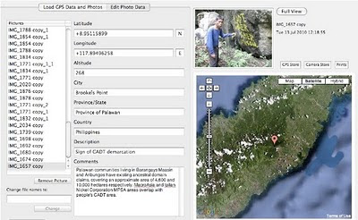
The area for which SEP clearance is being sought consists of well-conserved forest which provides clean water to lowland communities and which is also part of the traditional territory of Palawan tribes living in Brooke’s Point Municipality. During the last PCSD meeting, thanks to the support of Atty Grizelda Mayo-Anda (representing the NGOs community within the Council) and through the effective mediation of Governor Abraham Kahlil Mitra, the ALDAW network (Ancestral Land Domain Watch) was allowed to present ‘geotagged’ findings collected in two separate field surveys carried out in collaboration with the Centre for Biocultural Diversity (CBCD) of the University of Kent (UK). In a photographic context, geotagging is the process of associating photos with specific geographic locations using GPS coordinates. GPS coordinates were obtained through the use of a professional device connected to the camera’s hot shoe during the entire mission’s reconnaissance in the hinterlands of Ipilan and Maasin (Brooke’s Point Municipality). The obtained GPS coordinates were later overlaid on PCSD maps to show the overlapping between core zones and MAC mining activities. Overall the findings indicates that: 1) over 95% of test pits and drilling holes in MAC MPSA area are located in “core zones” and biodiversity rich forest, 2) Isolated Indigenous communities are living in the MPSA area of MAC (these have never been consulted about MAC operations); 3) The 91ha for which SEP clearance is being sought by MAC (out of a total MPSA area of more than 1,300 ha) overlap partially with “core zones” and entirely with well-conserved and residual forest. Even more surprisingly, the mission found no evidence of test pits and drilling holes in the recommended 91ha area. “This area includes sacred places where our Palawan indigenous communities carry out their own rituals. Moreover, portions of the Ipilan river and other tributaries which provide potable and irrigation waters to the lowland farmers are also found inside the area” explained ALDAW Chairman Artiso Mandawa.

In a nutshell the joint ALDAW/CBCD presentation clearly demonstrates that MAC mining interests are really concentrated in primary virgin forest. Geotagged photos portray test pits and drilling holes, found around 800m and even above 1,000m ASL. These evidences generated a lively debate amongst PCSD council members. PCSD representative/Congressman Antonio C. Alvarez asked confirmation to MacroAsia spokesman on whether their explorations activities are really located in core zones of “maximum protection”. To the surprise of all participants, MACROASIA representatives did not deny but rather confirmed the evidences brought forward by the ALDAW investigation team. However, they also stated that their permit to explore in ‘core zone’ was legally given by DENR and further endorsed through a SEP clearance by the PCSD. This assertion gave more ground to Congressman Alvarez to challenge Romeo Dorado, PCSD executive director: “a permit to explore core zones is not just a piece of paper, it actually entails the manipulation and disturbance of areas that, in principle, should be maintained free of human disruption. If the PCSD has allowed the exploration of core zones, it means that there is something wrong here” said Alvarez. Director Romeo Dorado clarified that, although the area used by MAC for exploration purposes is mostly located in core zones, the PCSD is only prepared to endorse to MacroAsia 91ha area out of the total MAC MPSA area of about 1300ha. Dorado’s reassurance was unconvincing and raised more questions than answers. In fact, according to the evidence presented by ALDAW team, there are no signs of exploration in the proposed 91hectares, no test pits and drilling holes and – in fact – as it was later confirmed by MacroAsia itself - no valuable minerals are found in the applied area. “What’s the purpose of getting an endorsement for this area, while the minerals that the companies want to extract are located much further in the uplands?” asked Alvarez. Atty Gerthie Mayo-Anda picked up on this argument: “we should really understand the ‘economic implications’ of the 91-hectare area. Surely if the company does not consider it commercially viable to just mine 91 hectares, they would want a much larger area which means that their targets for mineral extraction are really the core zones and the protected area!” said Mayo-Anda. Again, MacroAsia representatives had no valid argument on which to cling and rather admitted that the 91ha area for which SEP clearance is requested will be used as an ‘installation base for the company’. Having said this, MAC representatives provided no information on the exact location where the actual mining extraction would actually take place. During the meeting, Atty. Mayo-Anda further stressed that MAC’s MPSA area is located inside the recently declared Mount Mantalingahan Protected Landscape (MMPL), pursuant to Presidential Proclamation no. 1815. MacroaAsia representatives contested the assertion by claiming that, according to the same Proclamation, any valid contract for the extraction of natural resources already existing prior to the proclamation should be respected until its expiration. According to Dr. Dario Novellino (CBCD researcher and partner of ALDAW) the MAC spokesmen omitted a very important paragraph found in the same proclamation which specifies that areas covered by such contracts, which are found not viable for development after assessment shall automatically form part of the MMPL. “According to our field research, the areas claimed by MAC is not viable for any form of aggressive development, due to its particular ecological characteristics and specific landscape value” said Novellino. Atty. Mayo-Anda further challenged the MAC spokesman by clarifying that “the vested argument is skewed and cannot be sustained. It is well-settled in Philippine jurisprudence that exploration, development and utilization of natural resources through licenses, concessions or leases are mere grants or privileges by the State; and being so, they may be revoked, rescinded, altered or modified when public interest so requires” said Mayo-Anda. While MacroAsia representatives admitted that their concession overlaps with the Mantalinghan Proclaimed area, they also questioned how much of it is really located in core zones. “Part of their defence argument was based on their own subjective interpretation of core zone. They kept arguing that ‘core zones’ are above 1000 m ASL, to prove that most of their exploration and extractive activities are legal, being below that altitude. In reality according to SEP law core zones do not just include areas above 1000 meters elevation but all types of natural forest: first growth forest, residual forest and edges of intact forest, endangered habitats, etc. These are exactly the kind of places where MAC has been concentrating its own mining activities” said Novellino.

To the surprise of both NGOs and indigenous participants, the representative of the Mineral Geoscience Bureau of the Department of Environment and Natural Resources proposed that it would be better to revise the ‘core zones’ rather than challenging the company’s actions and operations. Again this statement ignited the debate even further “ECAN amendment in Brooke’s Point would be inconsistent. Any proposed change to the zoning system should be discussed publically in a Barangay Assembly and in close consultation with the communities. Core zones should be protected rather than amended to accommodate the interests on the mining companies” responded Mayo-Anda and Congressman Alvarez.

In addition to geotagging and ocular inspection, MacroAsia was also challenged on the bases of social acceptability. “It will not be difficult to establish that the people of Brookes Point are overwhelmingly against any mining. This is what we indigenous peoples and farmers have been trying to communicate to the government for the past two years through public demonstrations and rallies but they did not listen” said ALDAW Chairman Artiso Mandawa.

MAC representatives insisted that, as far as social acceptability is concerned, all documentation from the National Council for Indigenous Peoples (NCIP) had already been secured. However, according to Commissioner Atty. Felongco representing the NCIP on the meeting “applications are still pending and no final decision by NCIP has been made. On the contrary, we have been requesting additional documentation to the local government, since two barangays have not yet been consulted”. Governor Baham, chairing the meeting, expressed his discontentment for the NCIP inability to respond promptly to the lack of documentation relating to ‘social acceptability’. “From now on, NCIP provincial office should communicate its findings directly to the NCIP national office. Passing through the regional office, delays the whole procedures and creates anomalies” said Governor B. Mitra. He also posed the question on whether and to what extent previous local government endorsements to MacroAsia would still be confirmed after the forthcoming Barangay election. “I think all these crucial matters should be re-discussed and reviewed by the new barangay administration, as soon as it is elected and become operative” said Governor Mitra. Adding more points to the argument, Atty. Mayo-Anda suggested “municipal government officials should visit personally the area claimed by MAC to get a clear idea of the location, vegetation cover and actual land uses; and such crucial decision cannot be made just by tracing lines on a map”. During the PCSD meeting, also former Congressman Alfredo Amor Abueg Jr. asked the Council for a re-evaluation of all requirements provided by MacroAsia, especially those related to Barangay government, NCIP and to the Province itself. “All previous endorsements given by the local government should now be re-evaluated on the bases of evidences brought forward by the ALDAW team” he said.

Hon. Baham Mitra, Governor of Palawan and newly elected PCSD chairman, finally approved the motion. This entails that the decision to endorse a SEP clearance to MacroAsia is deferred until a multipartite team composed of PCSD technical staff, local government officials, NGOs and Indigenous Peoples’ representatives visits the proposed area and investigates the ALDAW findings and all pending issues raised by the NGO community. The team should also be in charge of determining: 1) the legality of endorsements by local government units; 2) the expected impact of mining on indigenous culture and livelihood; 3) the potential impact of mining on tourism industry; 4) the economic value of the 91 hectares for which SEP clearance is being sought by MacroAsia.

“This is just an initial victory for the indigenous peoples and our NGOs supporters” commented Artiso Mandawa (ALDAW Chairman) at the end of the meeting. “It proves that illicit affairs are not unstoppable, when the evidence brought forward is there to light up every dark corner and to expose all bed practices of mining companies and their political allies” addend Mandawa.

Some reflections on the way forward

The last PSCD meeting agenda has shed light on a number of issues that apply not only to MacroaAsia but to the vast majority of mining companies in Palawan whose operations can be questioned both from the perspective of ‘social acceptability’ and ‘environmental sustainability’. Several major mining projects that are in the pipeline in Palawan have been endorsed by local government officials, but have not been approved by the communties that would host them. Mining incursion in core zones and forested areas of high-biological diversity has already occurred in other areas. Geotagging findings, as those collected with reference to MacroAsia MPSA area, have already been gathered for the concession areas of Ipilan Nickel Corporation (INC) bordering MAC concession, as well as for Bulanjao range, one of the most valuable biodiversity hot spots in Southern Palawan. Here the mining road of Rio-Tuba Nickel Mining Corporation has already reached the highest fringes of the Bulanjao, at an latitude of 859m, causing deforestation, sever soil erosion and damage to the Sumbiling river watersheds. Evidence indicates that also the mining applications of Narra Nickel Mining and Development, Inc. (NNMDC), Tesoro Mining and Development, Inc. (TMDI), and McArthur Mining, Inc. (MMI) - approved through a Financial and Technical Assistance Agreement (FTAA) – and partnering with the Canadian MBMI - will surely encroach into core zones leading to the devastation of precious watersheds, indigenous ancestral territories and productive rice-land. The same applies to the City Nickel company in Espanola municipality and Fujian-Sino Mining Corp in Roax Municipality.

To avoid the transformation of Palawan (the Last Philippine’s Frontier) into a mining destination the following actions would be required.

The Local Government (LGU)

The LGU should ensure that all mining related decisions which are likely to affect local communities and their environment, be discussed with an independent committee formed by indigenous peoples, local farmers, NGOs and IPs organizations’ representatives in order to enhance transparency and accountability in decision making process.

Moreover, the LGUs should stick to their original Municipal Comprehensive Land Use Plans (CLUPs) without trying to reclassify ECAN zones into multiple/manipulative use zones to allow extractive activities.

The PCSD should stop issuing permits to mining companies to operate in ecologically precious and/or fragile areas, since this is in violation with the agency’s own mandate. Even more importantly, PCSD should stop any attempt of changing the definition of core zones and other zones to allow mining activities in forested land. It has already been established that some definitions such as those of ‘controlled use zones’ have been amended by the Council to please big corporations’ interests. For instance, according to the SEP law, in Controlled Use Area – (the outer protective barrier that encircles the core and restricted use areas) “strictly controlled mining and logging, which is not for profit…may be allowed”. Recently the ‘not for profit’ specification has been eliminated, thus opening these zones to commercial extractive activities.

Evidence, also indicate that PCSD maps are also inconsistent with the SEP zoning criteria. For instance, those areas that encircle and provide a protective buffer to the ‘core zones’, rather than being demarcated in blue (the color of restricted-use zones) are demarcated in brown, the color of ‘controlled use zones’ where mining is now allowed. These inconsistencies should be explained and rectified by the PCSD, as soon as possible.

Before, issuing SEP clearances the PCSD should consult indigenous and farmers communities. As of now, this has never been the case.

The Department of Environment and Natural Resources (DENR)

The DENR should stop fast-tracking mining contracts in Palawan. It should make watersheds off-limits to mining, as well as those areas of high biodiversity and endemism, to include Indigenous Peoples’ Ancestral Domains. This should lead to the suspension of all existing MPSA and FTAA until all controversial issues and ambiguities are clarified.

Ultimately, the DENR should solve its inherent conflict of interest caused by its dual functions: on one hand protecting the environment and the indigenous peoples and, on the other, promoting mining. Therefore, it is suggested that the responsibility related to the issuing of mining licenses should be dealt with by the Department of Mines, Hydrocarbons and Geosciences.

The NCIP

NCIP should stop issuing certificate of pre condition/clearances to mining applications and influencing indigenous peoples into endorsing mining projects. NCIP should also ensure that all FPIC processes carried out in conjunction with mining issues are evaluated by an independent body formed by indigenous leaders elected by their own communities, by representatives of indigenous organizations and, if the latter require so, by members (researchers, journalists, advocates, etc) of foreign institutions.

The National Government

The State should call for an immediate halt of mining operations in Palawan since such activities contravene those provisions contained in well-know conventions ratified by the Philippine Gove[e.g. The Convention on Biological Diversity (CBD)], the UN Declaration on the Rights of Indigenous Peoples. The Convention concerning the Protection of the World Cultural and Natural Heritage and; the Convention for the Safeguarding of the Intangible Cultural Heritage.

Ultimately, the National Government should revoke the 1995 mining act and issue a new act placing more emphasis on human rights and ecological balance, while regulating mining for the public interest.

The Provincial Government

In late 2008, the provincial board of Palawan has passed a provincial resolution providing for a moratorium on small-scale mining for a period of 25 years. This local legislative effort is not enough to prevent large scale and exploration activities in the province. The Provincial Government should prove and demonstrate to the National Government that the revitalization of the mining industry is not compatible with the special environmental status of Palawan Island, nor with the PCSD’s primary goal of achieving sustainable development in accordance with the Strategic Environmental Plan (RA 7611).

The UNESCO

Having established Palawan as a “Man and Biosphere Reserve” the UNESCO should play a more incisive and pro-active role, specifically when national governments, such as the Philippines, violate the condition for which such ‘prestigious awards’ have been granted.

Source: ALDAW


Friday, July 30, 2010

Participatory 3D Modelling used for the development of a community conserved area management plan in Mexico

Maps like this one will help the communties to
have a better understanding of resources
when developing their management plans;
Photo: Irma Juan Carlos
Oaxaca, Mexico: From March until May 2010, three university students from Chile and Mexico supported the ongoing work of Chinantec research teams to develop a management plan for their community conserved areas.

Andrés Basante, a master's student from the Environmental Geography Research Center of the National Autonomous University of Mexico (CIGA - UNAM), led a series of community mapping workshops.
Tomás Ibarra, a master's student at the University of Kent, conducted fieldwork for his dissertation on the influence of a hunting moratorium on socio-cultural change in the Chinantla.
Antonia Barreau worked as a research collaborator to conduct a short study entitled “Effects of conservation activities on diet patterns in Chinantec communities”.
These results will be returned to the communities to be integrated into their management programs.

by Claudia Camacho
Mesoamerica Coordinator

Source: Global Diversity Foundation Update; Issue 4, July 2010

Thursday, July 29, 2010

Recreando nuestra Cultura, Mapeando nuestro Futuro


El cuento de un encuentro especial en Venda, Sur Africa, y un proceso comunitario de cartografía eco-cultural. Líderes indígenas del Altai (Rusia) y la Amazonía Colombiana, juntos con representantes de ONGs de Sur Africa, Kenia y Etiopía, acompañan a la comunidad de Tshidvizhe mientras que descubren una sencilla pero poderosa manera de expresar el pasado y el presente de su territorio  en mapas hechos a mano. Los mapas destacan la importancia de su cultura, los sitios sagrados, el territorio y sus modos de vida, y empoderan a la comunidad mapear el futuro por lo cual deben luchar.

Tuesday, July 27, 2010

Palawan ‘UNESCO Man and Biosphere Reserve’ in the grip of Mining Companies?

Puerto Princesa - ALDAW. On the 7th of June (see IC release) 600 protesters from farmers and indigenous communities reached the capital city of Puerto Princesa on Palawan Island requesting the Provincial Government not to endorse the proposed mining plans of MacroAsia and Ipilan Nickel Corporation (INC). As a result of the negotiations taking place between the protesters’ delegation and policy makers in Puerto Princesa, the Provincial Government agreed that endorsement of both MacroAsia and INC should have required further investigation. However, that promise was not honoured and, after a few days, the Provincial Government gave his endorsement to MAC and INC to operate in one of the best conserved biocultural paradises found in the Philippines, and in South-East Asia as a whole.

The area given out to mining concession is also inhabited by traditional indigenous Palawan having limited contacts with the outside world. Moreover, the Gantong range and neighboring areas where MAC and INC intend to operate are within the area recently declared as Mount Mantalingahan Protected Landscape, pursuant to Presidential Proclamation no. 1815.

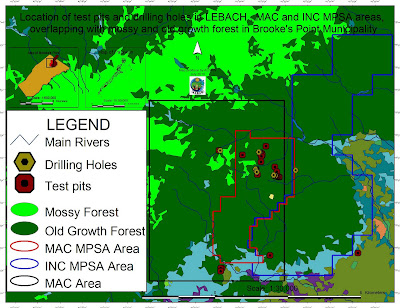
Location of test pits and drilling holes within the mining concessions and
their overlap with mossy and old growth forest in Brook's Point Municipality
Both the MPSA areas of MacroAsia and INC are located in ecologically valuable areas which include watersheds, hunting/ agricultural grounds, extractive reserves of Non-Timber Forest Products (NTFPs) such as Almaciga (Agathis philippinensis) resin, on which upland indigenous communities depend for their daily subsistence. Also indigenous peoples’ sacred and worship sites are found within the mining tenements of these companies.

Representatives of ELAC (Environmental Legal Assistance Center) are now filing cases against government officials and their respective agencies for having endorsed MAC and INC without securing first the needed social acceptability requirements and in disregard of the Strategic Environmental Plan (Republic Act 7611).

Say ELAC Atty. Edward G. Lorenzo: “the sustainable management of the entire Province is, in fact, governed by the SEP law which prohibits any human activity in those areas that are classified as ‘core zones’ and that – very unfortunately - are now part of MAC and INC mining tenements”. A indigenous member of the indigenous community of Gieb (Barangay Maasin, Brooke’s Point Municipality) also claims: “they (mining personnel of MAC) just entered our land without asking permission, and they removed our rice plants to excavate big ditches in our agricultural fields and also up into the mountains, only few meters away from the Balgtik (Agathis Philippinensis) trees that we sell and from which we depend for our survival”. According to another member of the same community: “MacroAsia peoples have removed soil and trees also in those sacred forest that we call lylien and that are inhabited by powerful super-human beings (Taw Kawasa)”.

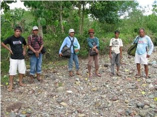
Between 12-16 July a geotagging field reconnaissance carried out by the ALDAW (Ancestral/Land Domain Watch) in collaboration with the Centre for Biocultural Diversity (CBCD) of the University of Kent has confirmed that MacroAsia test pits and drilling holes are found in ‘core zones’ (areas of maximum protection) around and even above 1,000 m ASL. Indigenous peoples trained on basic GPS and Geotagging technologies, with their own set of equipment divided into two groups to cover a large portion of the MAC and INC mining tenement area.

It appears that both MAC and INC have violated the basic tenets of the Strategic Environmental Plan (SEC) and also of the Indigenous Peoples Rights Act (IPRA Law), a national law protecting the interests of Indigenous Cultural Communities (ICC). Faced by this and similar accusations, the Provincial Government recently made a statement according to which MacroAsia and INC may not be allowed to operate in core zones, but their activities might be limited only to multiple/manipulative use areas. Again, ocular inspection and GPS data obtained by ALDAW and CBCD indicate the those portions of MacroAsia and INC mining concessions, which are outside the core zones, still include forested buffer zones which, obviously, do not fit by any means into the standard definition of ‘multiple/manipulative use zones’, where – according to the law – mining might be allowed. In fact, the mining claims of both MAC and INC are entirely located in ‘core zones’, ‘restricted zones’, agricultural and agroforestry areas that are subject to various cropping regimes. All these categories, according to the SEP law, should not be subject to any other form of large-scale extractive activity.

Also, lowland farmers are extremely concerned about the siltation of their wet-rice cultivation, as all irrigation water coming into their fields originates from the mountains where mining is supposed to take place. Members of academic institutions have suggested that: unless these precious water catchments are protected from mining operations, at least 50% of Brooke’s point sustainable agriculture, which requires irrigation, might be lost.

Says a spokesman of Alyansa Tigil Mina (the largest anti-mining advocacy group in the country) “Ironically enough the mining companies and the politicians who are endorsing them have also infringed the Philippine Mining Act which prohibits mining in old growth or virgin forest, proclaimed watershed forest reserves, wilderness area, and other areas of outstanding environmental value”. According to Atty. Mary Jean Feliciano of the ALDAW Network “in endorsing the mining exploration of both MAC and INC, the Sangguniang Bayan (Local Government of Brooke’s Point) has acted in contradiction with its own Municipal Comprehensive Land Use Plan (CLUP) for 2000-2010, in which mining was never considered as a development strategy and, in doing so, it has also bypassed the interests of local communities, as well as all forms of public consultations”.

Cornerstone of a CADT (Certificate of Ancestral Domain Title)

Undoubtedly, the endorsement by both Local and Provincial governments of the proposed operations of MAC and INC contravenes also those provisions contained in well know conventions [e.g. The Convention on Biological Diversity (CBD) and the UN Declaration on the Rights of Indigenous Peoples that the Philippine Government has already signed. Says a member of the Palawan advocacy community: “When the Government itself infringes its own laws so bluntly, it means that the fundamentals of democracy are breaking apart and a new form of state-led terrorism is coming into being to deprive hundreds of farmers and indigenous peoples of their traditional, and thus legitimate sources of life, just to benefit a handful of greedy and irresponsible businessmen and their cronies”.

On July 30, 2010 the members of the Palawan Council for Sustainable Development (PCSD) - a local government body in charge of the protection and sustainable management of the province - will meet to decide whether to issue a SEP clearance to the operations of MacroAsia and Ipilan Nickel Corporations. The future of one of the most pristine forests in the Philippines and the life of thousands of peoples who depend from it, is now in the hands of the Council.

Indigenous peoples and their networks, farmers, fisher folks, the Palawan NGO Network Inc (PNNI) and its associates, are uniting their effort to convince the PCSD to take a responsible decision which will ensure the sustainable future of Brook’s Point Municipality and of its biocultural diversity.


What you can do ...

Sign a Petition to Stop Mining in Palawan!


And address your concerns to:

Palawan Council for Sustainable Development
oed@pcsd.ph . and c/o Mearl Hilario mearlhilario@yahoo.com
FAX: 0063 (048) 434-4234

Honorable Governor of Palawan
Baham Mitra
abmitra2001@yahoo.com
FAX: 0063 (048) 433-2948

For more information watch ALDAW videos
http://www.vimeo.com/aldawnetwork
http://www.youtube.com/user/ALDAWpalawan
http://hub.witness.org/en/users/aldaw-network
or contact the ALDAW Network (Ancestral Land/Domain Watch) aldawnetwork@gmail.com  and Alyansa Tigil Mina (nc@alyansatigilmina.net / alyansatigilmina@gmail.com )

Friday, July 23, 2010

Le projet de cartographie participative dans le Bassin du Congo

Freddy Nguema Allogo est responsable technique du projet cartographie participative dans le Bassin du Congo par compte de Brainforest Gabon. Freddy décrives le projet et son état d’avancement.


Le projet régional de cartographie participative dans le Bassin du Congo pour la République du Congo a été lancé le 18 juin à Brazzaville. Initié par la Rainforest Foundation du Royaume Uni, ce projet qui s’étalera sur deux ans, sera mis en œuvre par l’Observatoire congolais des droits de l’homme (OCDH).

L’objectif global de la cartographie participative dans le Bassin du Congo est de promouvoir l’inclusion des droits des communautés forestières pour un contrôle et une utilisation rationnelle des forêts.

Le projet vise à renforcer les capacités des communautés forestières, de l’administration et des organisations de la société civile à mieux connaître les ressources forestières ; à soutenir les communautés forestières dans leur dialogue avec les autorités compétentes.

L’initiative de Rainforest Foundation traduit la volonté du Gouvernement anglais de ralentir le processus de déforestation par le développement des capacités des populations et des institutions des pays du Bassin du Congo dans la gestion durable des forêts, tout en assurant les meilleures conditions de vie aux communautés locales.

Ainsi, ces cartes géo référencées, une fois produites, devront mettre en valeur la richesse des écosystèmes forestiers du Congo et souligner les dimensions économiques, sociales et culturelles qu’ils représentent pour les populations qui y vivent

Tuesday, July 06, 2010

High resolution participatory satellite imagery interpretation in Southern Etiopia


A SPOT 5 scene was used to explore indigenous land use patterns, pastoral rangeland management and infrastructures with Borana pastoralist, a customary institution in Oromia region, Southern Ethiopia. Video material produced in August 2009. Contribution: Massimiliano Rossi

Sunday, June 13, 2010

RROMUEPATSRO: Mapping the Historical-Cultural Space of the Yanesha, Perú


This video is the first in a series titled “Where Our Ancestors Walked: Mapping the Historical-Cultural Space of the Yanesha People,” which was made in collaboration with the Yanesha people in order to preserve their history and its relation with their territory as sacred landscape. Rromuepatsro presents the Yanesha people, located in the eastern slope of the Peruvian central Andes, and explores their vital relationship with their ancestors and the natural landscape. It shows how they have used PGIS, anthropological research and Yanesha oral history to map their historical cultural space and thus reaffirm their millennial link to the ancient world and the civilization of the central Andes.

This video has been produced in Spanish and English by the Instituto del Bien Común (IBC), Lima, Perú.

Wednesday, June 09, 2010

Reviving our culture, Mapping our future


The story of a special gathering in Venda, South Africa, and a community process in eco-cultural mapping. Indigenous leaders from Altai (Russia) and the Colombian Amazon, and NGO representatives from South Africa, Kenya and Ethiopia, accompany Tshidvizhe community as they explore a simple yet powerful way to express the past and present of their territory and livelihoods onto hand-drawn maps. The maps highlight the importance of their culture, sacred sites and territory, and empower them to map the future they need to strive for.

Production: The Gaia Foundation, African Biodiversity Network (ABN), Mupo Foundation and the Technical Centre for Agricultural and Rural Co-operation ACP-EU (CTA).

Friday, June 04, 2010

Participatory mapping at IFAD

The International Fund for Agricultural Development (IFAD) is implementing the project “Piloting IFAD’s Participatory Mapping Approach for Specific Livelihoods” through innovative twinning arrangements.

The second phase of the project has focused on participatory mapping. As a result IFAD published “Good Practices in Participatory Mapping” and the “IFAD Adaptive Approach to Participatory Mapping”.

The next phase is focusing is participatory monitoring and evaluation of participatory mapping processes.

Below are the main outcomes of the second phase:
  • The International Fund for Agricultural Development (Corbett J. M.) (2009) “ Good practices in participatory mapping.” The International Fund for Agricultural Development, Rome, Italy. 55 pages.