Friday, November 27, 2009
Eco-cultural mapping to protect natural resources and sacred sites, South Africa
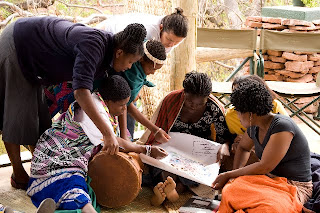
The case of the vhaVenda people echoes throughout many other rural areas in Africa and amongst other groups of traditional and indigenous peoples – the loss of communally owned territories, the expansion of industrial plantations and non-sustainable forms of land and resource use including tourism, the erosion of cultural values and sacred sites. With support from CTA, women, men and youth from Tshidzivhe community, in Limpopo province, northern South Africa, spent six days exploring ways to ‘map’ their traditional knowledge and practices for managing their natural resources. As the different maps were finished, the local people celebrated their new capacity to express traditional environmental knowledge in an appropriate way for gaining recognition, reviving traditional practices and securing their rights.
This was a unique mapping experience that involved local people as well as indigenous from other parts of the world. More than 70 vhaVenda people took part, guided by trainers in eco-cultural mapping from Colombia and accompanied by indigenous leaders from the Colombian Amazon and the Russian Republic of Altai. The process required the full participation of community members, especially the elders and the makhadzis, women custodians of sacred sites, but with minimal materials or technology.
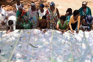
Four maps and two ecological calendars were produced, covering what the local population refers to as “Venda territory” and with special attention to the main sacred sites. The maps show the changes and alterations to the land - the past, present and future visions - and the importance of recovering traditional practices and rituals.
Trainees from Kenya and Ethiopia, members of the African Biodiversity Network, took part and hope to carry out similar workshops in their respective countries in 2010.
Photos by Will Baxter, text by Fiona Wilton / The Gaia Foundation
Saturday, November 21, 2009
Ogieks will not be evicted from the Mau forest
As reported by NTVKenya on October 24, 2009 , it is emerging that members of the Ogiek indigenous community will not be affected by the eviction notice. the Mau task force committee says the indigenous forest dwellers will not be moved when the evictions start soon. The announcement came as the Prime Minister gunned for more financial support for the Mau in Europe.
Related news and actions on PPgis.Net Blog:
Ogiek Appeal to the Kenya Government Notice to vacate Mau Forest Complex and other water towers
The 2009 UNESCO World Report on Cultural Diversity makes reference to the Ogiek 3D Mapping
Francis Kakwetin Lesingo reports on the use of a 1:10,000 scale 3D model in Nessuit Kenya
More on indigenous mapping by Ogiek People in the Mau Forest
Friday, November 13, 2009
Peter Poole reports on his experience with community mapping
In this interview, Peter Poole traces the evolution of a map-making methodology which commenced with his introduction of GPS to the Inuit community of Pangnirtung in 1989 and was incubated throughout the 1990’s by a series of ‘tenure mapping’ projects in the Amazon the Arctic and Asia. Tenure maps depict indigenous names, resources and special places on scaled maps, intended as evidence in negotiating land settlements.
Most tenure mapping methods rely upon external cartographic expertise. The “no-name” method enables communities to control the complete information cycle: gathering raw data, their conversion to information, its application.
The interview describes the search for cheap, simple, appropriate geomatic technology.
During several tenure mapping projects in the Amazon, a two-tier arrangement evolved whereby community-based teams would gather raw field data, the most critical task, and indigenous associations or support NGO’s, set up mapping units to serve the field teams.
The interview shifts focus to an overview of global community mapping completed by Peter Poole. In this, he concluded that, in terms of expertise, accessibility and accomplishment, the Philippines. He also drew a broad distinction to tenure mapping in America, a continent whose indigenous peoples sharing a in common ‘500 years since Columbus’ experience, and Africa, where this model does not work and where community mapping is taking off in a refreshing variety of directions.
The interview concludes with three lessons learned:
- Yes, communities can make their own scaled maps.
- The most successful of emerging mapping centres are those whose services are accessible to all communities.
- This capacity-building approach to map making equips and inspires people to diversify their skills in environmental information management. These skills will be wasted unless provisions are made to follow up tenure mapping projects with either further training or employment.
Labels:
Africa,
communities,
community,
mapping,
maps,
neogeography,
pgis,
ppgis,
tenure mapping
Saturday, November 07, 2009
Friday, November 06, 2009
Dave De Vera elaborates on Participatory GIS practice in the Philippines
Dave De Vera is the Executive Director of the Philippine Association For Intercultural Development (PAFID). In his interview Dave elaborates on the use of Participatory GIS practice in the Philippines to support indigenous communities in filing ancestral land claims. He elaborates on the mapping methods used, explains why P3DM is the most effective, and arguments on the need for local ownership of the process, competency of the technology intermediary, quality work, and constructive relationships with Government. Dave further lists cases of PAFID / Government partnerships and analyses the pillars of process legitimization.
Indigenous Peoples in Africa prepare for Copenhagen - REDD and human rights
With funding support from CTA, fifteen indigenous African leaders from East and Central Africa met in Bujumbura, Burundi to finalise a joint strategy and statement on climate change. Leaders from forest based communities in Gabon, Cameroon, DR Congo, Rwanda, Burundi, Uganda and Kenya participated in a joint UNIPROBA-IPACC policy meeting from 26-27 October 2009 to set out their concerns, priorities, action plan and statement ahead of the 15th Conference of Parties of the UN Framework Convention on Climate Change, due to take place in Copenhagen Denmark.
Delegates emphasised that indigenous peoples are important stakeholders in climate stabilisation in Africa. Indigenous leaders must educate their communities as to the causes and engage with national governments about equitable and sustainable responses. Delegates reported back on mitigation / REDD (Reducing Emissions from Deforestation and Forest Degradation) workshops that were held this year in Cape Town, Kampala, Nanyuki (Kenya) and Libreville, Gabon. The primary issues were to promote a fair and community-focused approach to REDD plus financing for forest conservation in Africa.
Government forestry officials from Uganda and Kenya gave presentations on how their governments are contracting with local communities to conserve tropical forests, and introduce new forms of carbon financing.
Jeniffer Koinante, Deputy Chairperson of IPACC gave a presentation on how the forest-based indigenous peoples of Kenya are using Participatory 3-Dimensional Models (P3DM) to help them review traditional adaptation customs, knowledge and practices, which could be harnessed to strengthen resilience of ecosystems and communities in the face of climate change.
Subscribe to:
Posts (Atom)