Showing posts with label maps. Show all posts

Thursday, September 15, 2016

The Power of Maps - Bringing the Third Dimension to the Negotiation Table

Participatory 3D modelling (P3DM) is one of the most remarkable innovations of the late 20th century. It is remarkable because it brings together three elements that many would consider incompatible – local spatial and natural resource knowledge, geographic information systems (GIS) and physical modelling.

As the inspiring accounts in this volume show, it can do this in many environments, of varied sizes and involving many people, sometimes more than a hundred and inclusively, both young and old. When well prepared and facilitated, as so amply illustrated here, the process gives rise to a progressive creative synergy. This empowers communities, by enabling them to share and express in lasting visual form the rich detail of what they know and by providing them with a tool for analysis, decision-making, advocacy, action and monitoring.

This volume bears testimony to the multiple uses and values of P3DM. In the examples described, the uses to which communities have put their models include natural resource planning and management; land and ocean rehabilitation; mapping their ancestral territories and establishing their rights; planning for conservation; disaster risk reduction and adaptation to climate change and variability; educating children in schools about their history and cultural heritage; bringing together community members with differences; and negotiating with officials and influencing policy.

Foreword by Robert Chambers, IDS

Download this publication
in English
in French

Wednesday, September 07, 2016

Sharing lessons with the world - Tonga’s P3DM success story

HONOLULU, 5 September 2016. Tonga was represented on the world stage at the World Conservation Congress in Hawaii this week. The island kingdom successfully carried out Participatory Three-Dimensional Modelling (P3DM) for the Vava’u island group this year as part of the Integrated Island Biodiversity Project.

At a special event to launch the Power of Maps book at the World Conservation Congress, Ms. Ana Fekau, the IIB Project Coordinator of Tonga shared their story of the P3DM process and how it helped to strengthen community engagement in planning for the conservation of biodiversity in Tonga.

“The process in developing the first P3DM in the Kingdom of Tonga brought communities together, the elderlies, youth and school children. The P3DM was not just a tool for planning purposes, but was also a tool to empower communities and to hear their voices through the stories they were sharing during the process,” said Ms. Fekau.

Hindou Ibrahim Omarou opening the session on the book lauch
(Image credit: Mikaela Jade)
The IIB Project supports an integrated ecosystem approach to the biodiversity conservation management at the local level in the Cook Islands, Nauru, Tonga and Tuvalu. The four year project finishes at the end of this year.

“The World Conservation Congress has provided an excellent platform to showcase and share Tonga’s P3DM work that was successfully completed under this project, and the expansion of this work to Nauru and the Cook Islands,” said Ms Easter Galuvao, Biodiversity Adviser at the Secretariat of the Pacific Regional Environment (SPREP).

Ms Ana FeKau presenting at the book launch
(Image credit: Nigel Crawhall)
During her presentation, Ms Fekau explained the 3D participatory process, the challenges faced and valuable lessons resulting from Tonga’s P3DM, including her role in the successful replication of P3DM in the main island of Tongatapu.

I wish to express sincere thanks and acknowledge the GEFPAS IIB Project and SPREP for facilitating the P3DM for Tonga, the Samoa Ministry of Natural Resources and Environment for providing their valuable technical expertise and to the Technical Centre for Agricultural and Rurel Cooperation ACP-EU (CTA) for their support,” said Ms Fekau during her presentation.

The presentation was given at a side event at the IUCN World Conservation Congress (WCC) currently underway in Honolulu, Hawaii is attended by over 9,000 participants from around the world and will wrap up on the 10 September.

The GEFPAS Integrated Island Biodiversity (IIB) Project is funded by the Global Environment Facility (GEF), implemented through the United Nations Environment Programme (UNDP) and executed by SPREP in the Cook Islands, Nauru, Tonga and Tuvalu.

Note: Ms Ana Fekau works at the Ministry of Meteorology, Energy, Information, Disaster Management, Environment, Climate Change and  Communications (MEIDECC), in Nuku`alofa, Tonga

Friday, September 02, 2016

Making Maps, Third Edition: A Visual Guide to Map Design for GIS

Lauded for its accessibility and beautiful design, this text has given thousands of students and professionals the tools to create effective, compelling maps.

Using a wealth of illustrations--with 74 in full color--to elucidate each concisely presented point, the revised and updated third edition of Making Maps: A Visual Guide to Map Design for GIS continues to emphasize how design choices relate to the reasons for making a map and its intended purpose.

All components of map making are covered: titles, labels, legends, visual hierarchy, font selection, how to turn phenomena into visual data, data organization, symbolization, and more.

Innovative pedagogical features include a short graphic novella, good design/poor design map examples, end-of-chapter suggestions for further reading, and an annotated map examplar that runs throughout the book.

by John Krygier PhD (Author), Denis Wood PhD (Author)

Paperback: 293 pages
Publisher: The Guilford Press; 3 edition (August 2, 2016)
Language: English
ISBN-10: 1462509983
ISBN-13: 978-146250998

Thursday, January 21, 2010

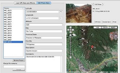
The Bulanjao Geotagged Report

On August 2009, a mission led by the Philippines-based Ancestral Land/Domain Watch (ALDAW) and the Centre for Biocultural Diversity (CBCD) at the University of Kent traveled to Barangay Sumbiling, Municipality of Bataraza, Province of Palawan (Philippines).

Geo-referenced audio-visual and photographic documentation was carried out in the Bulanjao range whose vegetation consists of a very unique type of forest growing on ultramafic /heavy-metal rich soils. The area is home to at least four plant species that are classified as vulnerable and two of them have already been included in the IUCN Red List.

In spite of its unique ecological features, the Bulanjao range has been subjected to mineral exploration and development by the Rio Tuba Nickel Mining Corporation (RTNMC). RTNMC is a Filipino-Japanese partnership holding a mining concession area of about 5,265 hectares.

RTNMC and its partner, Coral Bay Nickel Corporation (CBNC), need to mine nickel ores as part of the expansion of their new Hydrometallurgical Processing Plant (HPP) project. However, one the conditions specified in the Environmental Compliance Certificate (ECC) issued to them in 2002, is that “core zones” - as identified by the Strategic Environmental Plan for Palawan (Republic Act Republic Act 7611) should not be included in the areas of mining operations and, this, of course includes the Bulanjao range.

Starting at an elevation of about 40m ASL, the ALDAW/CBCD mission followed the mining road to reach the highest portions of the Bulanjao range. Geo-tagging evidence indicates that erosion on the Bulanjao mining road is occurring also at low elevations. During the rainy season the water creates deep clefts on the roadsides, hence penetrating the soil and fostering road collapse. No mitigating measures have been put into place to reduce erosion. A huge crater-like excavation has been found at 566m ASL. and land slides, induced by road construction, have been documented around the sources of the Sumbiling river, at almost 900m ASL. The latter is the most important water source for both lowland farmers and indigenous communities.

Marylin Samparan, a local IP living in the area told the mission: “time will come when our children will no longer recognize the names of trees, the footprints of animals, the birds’ songs. This will be the time when the forest will be gone, the mining companies will be gone, the rivers will no longer flow…and us? We will still be here”.

On 15 August 2009, the mission established that mining road had already reached an altitude of 859m ASL – and its exact location was defined through the following GPS coordinates (+ 8.59322548 N Latitude and + 117.36516571 E Longitude).

Mission’s findings have now been compiled into a geo-tagged report, which is being used by local indigenous communities to support their legal struggle against mining in Bulanjao.

Source: The ALDAW NETWORK

The ALDAW NETWORK (Ancestral Land/Domain Watch) is an advocacy-campaign network of Indigenous Peoples jointly constituted by NATRIPAL (United Tribes of Palawan) and BANGSA PALAWAN PHILIPPINES (Indigenous Alliance for Equity and Wellbeing) on August 2009.

Friday, November 13, 2009

Peter Poole reports on his experience with community mapping


In this interview, Peter Poole traces the evolution of a map-making methodology which commenced with his introduction of GPS to the Inuit community of Pangnirtung in 1989 and was incubated throughout the 1990’s by a series of ‘tenure mapping’ projects in the Amazon the Arctic and Asia. Tenure maps depict indigenous names, resources and special places on scaled maps, intended as evidence in negotiating land settlements.

Most tenure mapping methods rely upon external cartographic expertise. The “no-name” method enables communities to control the complete information cycle: gathering raw data, their conversion to information, its application.

The interview describes the search for cheap, simple, appropriate geomatic technology.

During several tenure mapping projects in the Amazon, a two-tier arrangement evolved whereby community-based teams would gather raw field data, the most critical task, and indigenous associations or support NGO’s, set up mapping units to serve the field teams.

The interview shifts focus to an overview of global community mapping completed by Peter Poole. In this, he concluded that, in terms of expertise, accessibility and accomplishment, the Philippines. He also drew a broad distinction to tenure mapping in America, a continent whose indigenous peoples sharing a in common ‘500 years since Columbus’ experience, and Africa, where this model does not work and where community mapping is taking off in a refreshing variety of directions.

The interview concludes with three lessons learned:
  • Yes, communities can make their own scaled maps.
  • The most successful of emerging mapping centres are those whose services are accessible to all communities.
  • This capacity-building approach to map making equips and inspires people to diversify their skills in environmental information management. These skills will be wasted unless provisions are made to follow up tenure mapping projects with either further training or employment.

Saturday, October 10, 2009

Participatory 3D Modelling: a Review ...

Giacomo Rambaldi makes a summary of his involvement in the improvement, development, promotion and dissemination of a participatory mapping method better known asl Participatory 3D Modelling (P3DM).


Participatory 3D Modelling (P3DM) is a community-based mapping method which integrates local spatial knowledge with data on elevation of the land and depth of the sea to produce stand-alone, scaled and geo-referenced relief models. Essentially based on local spatial knowledge, land use and cover, and other features are depicted by informants on the model by the use of pushpins (points), yarns (lines) and paints (polygons). On completion, a scaled and geo-referenced grid is applied to facilitate data extraction or importation. Data depicted on the model are extracted, digitised and plotted. On completion of the exercise the model remains with the community. More information on the method are available at iapad.org

Sunday, October 04, 2009

Participatory 3D Model of the historical Wechecha mountain complex, Ethiopia

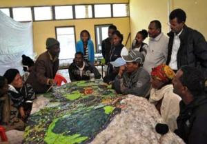
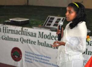
MELCA Mahiber, an Ethiopian NGO which is part of the African Biodiversity Network (ABN) facilitated the construction of a Participatory 3 Dimensional Model (P3DM) of the historical Wechecha mountain complex, which is found in Oromiya Regional State, adjacent to Wolmera and Sebeta Awas Woreda in Ethiopia.

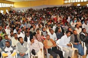
Once completed the model has been inaugurated by a Representative of the President of Federal Democratic Republic of Ethiopia. Over 500 people participated in the ceremony including members of the House of People Representative Councils, governmental officials and representatives from international organizations, CSO and local communities.

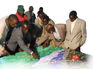
The 1:10.000 scale model covers an area of 24 km by 28 km. Over 40 students and representatives from youth groups constructed the blank model. Residents of the area, especially elders, were invited to populate the map with their spatial knowledge. In the process information about the mountain area has been shared across generations and between local communities and other stakeholders, opening the door for deeper discussions on the sustainable management and safeguarding of both local culture and environment. The local Governors were very supportive. They played an active role in the process together with the organisers.

The objective of the exercise was to document the Traditional Ecological Knowledge (TEK) of resident communities, and add value and authority to it in order to increase the value external authorities would attach to it when it comes to collaborative natural resource management. A second objective of the exercise was to enhance the transfer of TEK the younger generations.

Now thet the model is completed it will as a reference environment where local people, government officials and other stakeholders can discuss management and rehabilitation plans.

Kalkidan is a 15-year old student at Holeta Primary School. She witnessed how this model created an opportunity for her and her friends to learn a lot from the local elders. At the inauguration she stated the following: “We youngsters didn’t think that elders know, but now, after participating in the construction of this Participatory 3 Dimensional Model, we are convinced that our elders have a deep knowledge about their environment” She recalled that the elders were the main actors on the scene.

At the ceremony Elders locaed their places of origin on the model and talked about them. They couldn’t hide their feeling that their area is becoming degraded and pleaded for concerned bodies to address this problem. The government representatives also endorsed the model and reiterated that it should not be just for looking at and admiring.”

Dr. Tewoldebithan G/Egziabher, Director of the Federal Environmental Protection Authority and Chairman of MELCA’s General Assembly delivered the model to Holeta Town and Wolmera Woreda Administrations on behalf of MELCA. He told to the Administrations to use the model as a reference for taking measures.

According to Million Belay the Director of MELCA related initiatives will follow: There will be an intensive planning process aiming at rehabilitating the Wechecha Mountain complex and we will ensure that the model will be central to it. Schools located at the foothills of the mountain will make use of the model in their curriculum like it is currently happening in Nessuit Kenya, where a similar model has been constructed in 2006. Teachers use it to facilitate pupils learning about their environment, geography and cultural landscapes. In addition, Mr. Belay stated that the 3D model will be used for scientific research, on the relationship between people and the environment, and to study the impacts of land degradation on the livelihood of local communities.

Wednesday, June 17, 2009

P3DM after the 2007 World Summit Award

In November 2007 "Participatory 3D Modelling (P3DM) for Resource Use, Development Planning and Safeguarding Intangible Cultural Heritage in Fiji" was proclaimed as one of the four winners of the “Worlds Best e-Content 2007” in the World Summit Award category e-Culture.

Here is an account of what has happened since the exercise was carried out in Fiji.

Since 2005 (year in which the project in Fiji was implemented) Participatory 3D Modelling (P3DM) and been adopted in development contexts in many parts of the world (http://www.p3dm.org/) including Cambodia, Colombia, East Timor, Ethiopia, France, Guyana, Italy, Kenya, Malaysia, Nepal, PNG, Australia and other countries.

The 2007 WSA recognition added value and authority to the method and gave worldwide recognition to its quality and appropriateness.

In Kenya P3DM been used by Ogiek, Yiaku and Sengwer Indigenous Peoples to document their biophysical and cultural landscapes. The objectives of these community-led interventions included enhancing inter-generational information exchange, adding value and authority to local knowledge, improving communication with mainstream society, improving planning on sustainable management of natural resources and addressing territorial disputes.

In Ethiopia P3DM has been used to assist stakeholders in the Bale region to plan out sustainable management of the area, revive their bio-cultural diversity and support local environmental education.

The Indigenous Peoples of Africa Coordinating Committee (IPACC), a pan-African network of 150 organisations adopted the method and is spearheading its adoption in the African Continent to improve awareness at policy-making level on the relevance of location-specific traditional ecological knowledge (TEK) in climate change adaptation and mitigation processes. Read more.

UNESCO has been supporting the adoption of P3DM in Niger and Kenya in the context of the of the Convention for the Safeguarding of the Intangible Cultural Heritage paying specific attention on the opportunity for safeguarding traditional ecological knowledge as part of overall intangible cultural heritage and its integration into the education curricula.

In collaboration with national and regional partner organisations, the Technical Centre for Agricultural and Rural Cooperation EU-ACP (CTA) is supporting the dissemination and adoption of P3DM practice in ACP countries. Regional capacity building exercises are scheduled in Central Africa (Gabon and DCR), West Africa (Niger) and Southern Africa (Botswana) in 2010 and 2011.

In collaboration with a number of development agencies, CTA is spearheading the production of a training kit supporting the spread of good practice in generating, managing, analysing and communicating spatial information. The kit includes a module on participatory 3D Modelling.

Other initiatives include the ongoing online participatory translation of a video documentary on P3DM “Giving the Voice to the Unspoken” using the free platform http://dotsub.com/

Saturday, May 09, 2009

Interview with Mr. Million Belay, coordinator and facilitator of the P3DM exercise recently conducted in Bale, Ethiopia

Q1: Dear Million, could you briefly introduce yourself and the organisation you are working for?

My name is Million Belay. I am Ethiopian. I am a graduate in Tourism and Conservation, currently doing PhD on bio-cultural diversity. I am the director of MELCA Ethiopia.

Q2: In 2006 you attended a training on Participatory 3D Modelling (P3DM) organised by CTA in collaboration with ERMIS-Africa in Nessuit, Kenya. At that time what were your thoughts about the P3DM method?

I was not sure about it. It did not strike me as something special. But after seeing how it has mobilized the knowledge of the local community, I was really impressed. I have some experiences in community mapping but P3DM was beyond my expectations. I still feel as if I know the Mau complex even if I did not visit it physically.

Q3: Did you think about replicating the P3DM process in Ethiopia?

Yes very much. That was what was in my mind since I came from Kenya. I had to wait for the right time though.

Q4: How did you go about organising the exercise in Bale?

The P3DM handbook (Participatory 3D Modelling: Guiding Principles and Applications) was extremely useful. The website www.iapad.org was also an excellent source of complementary information. I could get almost all of the answers from the handbook. My communication with Giacomo Rambaldi from CTA was a huge help. Our face to face discussion in at the IUCN World Congress in Barcelona also helped a lot, although one has to live through the experience to really understand it. I had to use substitutions for the materials suggested in the guide. I had to encounter a difficulty to understand what some of the recommended inputs were meant to serve for. Every bit was a challenge and meeting those challenges was an exhilarating experience.

Q5: You have now undergone a P3DM process in the role of lead facilitator. What are your most important considerations in terms of participation of knowledge holders in the process?


I think that P3DM is an excellent tool for community participation. The first group of participants was challenged. We had about seven groups. We prepared the map legend before the model has started. After it was assembled, we invited the first community and asked them for a feedback. They changed some legend items. There was a heated argument about the location of some of the rivers. We had forgotten to put one mountain on the Model and that has resulted in some confusion. One mountain was incorrectly named on the source map and this generated a lot of discussion. But local knowledge holders corrected the name. Later on a cartographer confirmed that the source map was incorrect. The women were very strong. They would not accept what the men were suggesting. The men had to reconcile. There was no bystander. The youth and children also participated in the discussions. They were suggesting the names of some of the places and checking these with the elders. It was a fascinating exercise. Local Government officials participated as well. The mayor of the small town said, for example, that if we need to construct a house to place the model, he will give us land. So I found the model to be a social catalyst.

Q6: Did you collect feedback from participants? If yes, which one were the most revealing statements?

Yes! Most of the participants stated that the model revealed them a broader landscape. There were many sad comments also.

One elder stated that “You see I know that the area where I live is degrading. Forests are disappearing. I used to tell myself that ... well, it is only here. The other part of Bale is fine ... But after I saw the model, I could see that Bale in general is degrading. Forests are disappearing. Agriculture is expanding. Grazing areas are disappearing. I really feel very sad and alarmed.

A woman said “Well, as a woman I am not expected to go far. I only know some water points and areas where I collect fire wood. I also know villages of my relatives. Now I can see a larger landscape. Through the discussion I now understand what the Bale Mountains look like. This has broadened my understanding of what we have and what our problems are.”

An elder stated “You know we used to have big forests that we protect through out beliefs. Nobody touches these forests. Now I hear that this practice is rapidly declining. We are loosing our forests because of this. This generation does not understand the value of these things. They ridicule it. I can see that Bale is becoming naked. It is as shameful as undressing a women in public.”

Q7: How would you describe women’s participation compared to the one you observed in Nessuit, Kenya?

Women participated actively.

They did not wait till the men went for lunch, like it happened in Kenya. They were fighting every bit for their voice to be heard. We have asked deliberately for women to be included among participants. They were so proud that they were invited. They also had more specific knowledge about some areas including rituals related to crossing points on a river.

I was amazed by their active participation as Bale is mainly Muslim and women are usually marginalized.

Q8: Who is going to safeguard and update the 3D model which is now hosted at the Dinsho School?

The model was officially handed over to the school. So presently the school will be the guard. But there is a discussion among MELCA and the other government officials that we should construct a house for it and host it in a larger and protected space. MELCA has a soil and water conservation as well as environmental education program in Bale. So we will use the model for this purpose. We are going to organize a three-day planning workshop on how best to use the model. The event will help us on how to best to use the model and how to continuously update it.

Q9: Are there any plans for extracting and digitizing the data visualised on the model? If so, what will be the role of the community in the process and in the management of the resulting data sets?

Yes there will be digitizing the data. There will be discussion with the community which layers they want to show and which to maintain confidential. We will also handover the printed maps to whomever they chose. We will also have a discussion with them on where to store the data. We have explained to them the purpose of the model and they have agree to participate in the process and are so glad that it was done.

Q10: Do you plan to facilitate the replication of the P3DM process elsewhere in Ethiopia?

Yes. We will do two models in Ethiopia probably in June and July 2009. We will see how it goes and will replicate it in other locations as well. What is so exciting is that our partners in the other parts of the Bale Mountains are planning to adopt the P3DM process as well. It is self replicating, it seems.