Showing posts with label gis. Show all posts

Tuesday, October 18, 2011

Mapping Land, Sea and Culture: an Award-winning Participatory 3D Modelling Process in Fiji


In 2005 CTA in collaboration with a number of locally based development actors introduced a participatory mapping method known as “Participatory 3D Modelling (P3DM)” in the Pacific Region. Activities took place in Levuka, the ancient capital of Fiji. Local residents were struggling with over-exploitation of their fishing grounds by foreign fishing fleets and their rich cultural heritage being hardly transmitted to the younger generations. After months of preparation and consultations on the island, the exercise took place in April 2005 involving local schools and representatives from 26 villages. Since the completion of the model residents have developed an island-wide natural- and cultural resource use management plan which was followed by 3 district management plans. Taboo (i.e. protected) marine areas have been established within the fishing grounds of 3 districts comprising 16 villages. Additional taboo areas have been set up by 10 villages on a nearby island partially included on the 3D model. In 2007 the case was granted the World Summit Award 2007 in the category e-culture and the P3DM process has been considered as one of the 40 best practice examples of quality e-Content in the world.

More information on the case is available at: http://goo.gl/85fmN

The exercise has been made possible by the coordinated effort of the Fiji Locally-Managed Marine Area (FLMMA) Network, the WWF South Pacific Programme (WWF-SPP), the Technical Centre for Agricultural & Rural Cooperation (CTA), the Native Lands Trust Board (NLTB), the National Trust of Fiji, the Land Resources Division of the Secretariat of The Pacific Community (SPC), and the Lomaiviti Provincial Council of the Ministry of Fijian Affairs and Provincial Development.

How do I implement P3DM? Here is a complete handbook (EN | FR | ES).

Saturday, September 24, 2011

What is Volunteered Geographic Information/Crowdsourcing?


Shawn Simpson explores the definition and use cases for volunteered geographic information in public safety and local government.

Monday, May 23, 2011

Participatory 3D Modelling for developing climate change adaptation plans in Boe Boe, Solomon Islands

I’d like to thank all the team who made the ten-day ‘Participatory 3D modelling (P3DM) for climate change’ engagement with Boe Boe community, Solomon Islands, such a successful event.
It is the first time that such innovative, yet simple, mapping and communication tools have been used in the context of climate change adaptation.
The team, led by Kenn Mondiai of Partners With Melanesians, and the Solomon Islands’ TNC staff and local partners, were able to hand over a vibrant, illustrated, ‘living’ and accurately-scaled model of the community customary lands and waters, at a ceremony involving Boe Boe village and neighboring communities.
The model took teams of students and volunteers 3 days to build, and then community members added the detail – from their own houses, their gardens, their route through the mangroves, forest paths, conservation areas, and anything else they reckoned important to note.
At the same time, climate vulnerability and adaptive capacity surveys with households, led by Esther Ririmae and Gideon Solo, and follow-up work by the team with community members on a range of key issues, allowed the modeling exercise to focus on community perspectives of climate change impacts, and the villagers’ collective ability to respond to these and other development pressures.
Of real interest, digital and ‘scientific’ modeling provided by TNC GIS folks (Nate Peterson, Seno Mauli) and Javier Leon of University of Wollongong, was seamlessly integrated into the mapping exercise and gave the community additional perspectives on their local knowledge, to aid decision-making.
The exercise has given all those involved, and all the partners in the Australian Government / AusAID supported project ‘Building the Resilience of Communities and their Ecosystems to the Impacts of Climate Change’, a chance to explore how local communities can assess potential climate impacts, be aware of their own capacities and vulnerabilities, and make decisions going forward.
Please find the attached initial write-up of the activity in the 'files' section at this link http://community.eld...  , along with some resources on conducting P3DM. More detailed reports will follow from Partners With Melanesians and other papers on the lessons learned from the exercise.
The guru of P3DM, Giacomo Rambaldi, based at the Technical Centre for Agricultural and Rural Co-operation (CTA) in the Netherlands, has worked with both Kenn and myself before on the tool, and has an online resource kit available at http://pgis-tk-en.cta.int
Next up is 3D modeling at the provincial scale in Manus!

The initiative has been implemented in the framework of the Australian Government / AusAID-funded project ‘Building the Resilience of Communities and their Ecosystems to the Impacts of Climate Change in the Pacific”.

Monday, May 09, 2011

Pacific Cultural Mapping, Planning and Policy Toolkit

This toolkit has been made possible by the generous contribution of the European Commission, through the Structuring the Cultural Sector in the Pacific for Improved Human Development project. The toolkit was drafted following the Cultural Policy Workshop held at the Secretariat of the Pacific Community (SPC) headquarters in Nouméa, New Caledonia from 25–28 March 2010, and is designed to provide guidance to countries and territories carrying out the cultural mapping, planning and policy process.
Culture permeates political, economic and social life across Oceania. Because indigenous peoples and practices have predominated across this region for hundreds – and, in some places, thousands – of years, culture is lived and directly influences the values, decisions and hopes of Pacific Island peoples. Culture in Oceania is primarily understood to reference the people or customs ‘of the land’ but in the 21st century many other ideas, beliefs and practices have now taken root. In addition, Pacific populations are increasingly mobile and have settled beyond their indigenous homelands. Similarly, the Islands have welcomed new migrants from other countries. Culture therefore involves old, new and continuously developing modes of thinking, being and creating.

Globally, this cultural process is of great economic and social importance: many countries in Asia, Europe, the Americas, Africa and the Caribbean prioritise culture for national investment, capacity building, human development, peace and security, economic growth and communal revitalisation. In the international context, culture is increasingly central to ‘creativity’ and ‘innovation’ – two concepts that are at the heart of the cultural or creative industries. In the Pacific Island region, however, these industries are not clearly defined and programmes or policies on culture are still seen to be primarily about promoting or safeguarding tangible and intangible cultural heritage including traditional knowledge.

Source: Secretariat of the Pacific Community (SPC)

Related topics:  Building Critical Awareness of cultural mapping. A Workshop Facilitation Guide. (UNESCO, 2009)

Monday, January 17, 2011

Looking Through a Mirror at our Past and Present: Account of a P3DM Exercise in Ethiopia

The leathery scent at the venue hall was nothing more than the confirmation that we were working in rural Ethiopia, in a village called Telecho, some 30 kilometres north of Holeta. We had just gathered with 20 delegates coming from Ethiopia, Kenya, Tanzania, South Africa, Uganda, Cameroon and Benin to co-facilitate a participatory mapping exercise implemented by more than 130 villagers coming from 28 kebeles located within the area and foothills of a mountain known as Foata.

The exercise – organised by MELCA-Ethiopia, a national NGO and supported by the Technical Centre for Agricultural and Rural Cooperation ACP-EU (CTA), was a response to a call by the community for assistance in rehabilitating its environment which suffered heavy deforestation and soil degradation over the past decades. After several month of preparation, the exercise took place on 8-18 December 2010 in the village of Telecho amidst a golden landscape shimmering with wheat, teff and rye at maturity stage intersected by dark brown strips of ploughed land and exposed soil cloths weltering in the choking sun.

Close to 140 people worked in shifts on the model which covers – at a 1:10,000-scale - a total area of 672 sq km including portions of four woredas namely Welmera, Ejere, Adea berga and Mulo. Assisted by the trainers, 14 students, three teachers and the foreign delegates (the trainees) manufactured the blank model. Approximately 110 elders representing 28 kebeles contributed in overlapping groups to the elaboration of the map legend and the depicting of their mental maps onto the model. A number of representatives from local government units contributed to the exercise as well.

The assembling of the blank model using 3-mm thick sheets of carton board and measuring 2.8m x 2.4m, took three days while the depiction of the landscape and the location of features relevant to the community, took additional six days.

Selected elders introduced the first group of participants to the draft legend which was verified and further enriched in terms of items and their descriptors. Once completed, the model stored 48 layers of information including 25 point-, 5 line- and 18 area types. A count of point data done at the end of the exercise revealed that within the area there were 38 schools, 23 health posts, 113 sacred trees, 8 markets, 861 settlements and much more.

In terms of process, villagers from the first group introduced the second group to its task and the latter did the same with the third group. This ensured a full transfer of ownership of the entire process from the facilitators, who kick-started the process, to the informants, which proudly presented their output to the wider community and government representatives on the day of the inauguration and closing ceremony. Villagers worked with great attention and passion while depicting the landscape of their woredas. Animated discussions, exchanges, and negotiations characterised the process involving both men (the majority) and women. Traditional dances animated the start of the activities in the morning while work kept on rolling until night at the light of a generator.

A bull was slaughtered in anticipation of the closing ceremony which took place on 18 December 2010. The event signified the apotheosis of the process where elders (man and women) presented the legend and information featured on the 3D model and described the process which led to its production. The audience was composed of approximately 300 villagers originating from all 28 woredas, representatives from the parliament, local government, CTA, the Finnish Embassy and delegates coming from 9 African countries, representing NGOs and universities.

During the various phases of model making, participants were given the chance to express themselves and provide written feedback on the process using so called “democracy walls”. Democracy walls are large sheets of craft paper labelled as “I noticed”, “I learned”, “I discovered”, “I felt”, “I would like to suggest” where individuals can stick A5 sheets of paper where they have marked a statement related to the “label” and concerning the process experienced. In addition a professional media team documented the process and conducted interviews, and a group of youth was trained and assisted in producing a Participatory Video (PV).

Participating villagers reported that working on the model elicited powerful memories of a past landscape characterised by lush forests and permanent river courses, and made them realise how much the conversion of the matural habitat had impacted (negatively) on their life. Participants stated that through a self-reflection process they realised that their non-sustainable handling of the resources base had led to impoverishment of soils and decrease in crop yield, and that the present situation was threatening their livelihoods and mere subsistence. They stated that the process of model building created learning environment and gave them a sense of purpose. “The P3DM process enables the community to look at itself using the model as a mirror” wrote a villager on a card featuring on the “Democracy Walls”.

Written statements made by villagers (in Amharic) while working on the 3D model:

“I felt that - as we destroyed the natural resources in our surroundings, we lost the soil, the forest, wild animals and more. This in turn is harming ourselves and creating problems to coming generations”.
“I felt that I could compare what we did on the map with what existed in the past [in the real world], and this makes it clearer about what to do in the future”.
“I noticed that it [the process] helped me understanding the importance of participation. I also realized that the community has valuable knowledge that we were not aware of.” 
“I noticed that the P3DM process enables the community to look at itself using the model as a mirror. It builds capacities and that is important for the development of the country.”

Source: Democracy Walls, Telecho, 17 December 2010

The large gathering on 18 December reinforced the message as villagers involved in the mapmaking shared their realisations, increased awareness and statements of intentions. The presence of Government representatives who seemed bewildered by the view of the model at its unveiling, was much appreciated by the community members, and reinforced their perception of being considered and listen to in their pledge for working jointly for a better future. In this context villagers decided to convene a larger meeting to look into a series of actions which would help them rehabilitate their degraded land.

A few days after the completion of the exercise, MELCA was granted additional financial support by the Finnish Embassy to sustain follow-up activities related to the rehabilitation of the environment in the project area. The 3D model will play an important part in this process as it represents the most updated and most relevant repository of local spatial information and a planning tool which can be easily mastered at village level, as it is fully understood and endorsed by the local populace.

Last but not least, the national and international trainees expressed their intention to replicate the process in their areas.

Authors: Giacomo Rambaldi / CTA and Million Belay MELCA-Ethiopia
Images: G. Rambaldi / CTA© and Damian Prestidge / CTA©


Monday, November 22, 2010

The Power of Geographic Information


The Centre of GIS & Remote Sensing (SIGTE) of the University of Girona, presents “The Power of Geographic Information”.

Wednesday, November 10, 2010

Sacred Natural Sites: Conserving Nature and Culture

Edited by Bas Verschuuren, Robert Wild, Jeffrey McNeely and Gonzalo Oviedo

This book illustrates that sacred natural sites – the world’s oldest protected places – although often under threat, exist within and outside formally recognised protected areas and heritage sites. They may well be some of the last strongholds for building resilient networks of connected landscapes as well as forming important nodes for maintaining a dynamic cultural fabric in the face of global change.

The diverse authors bridge the gap between approaches to the conservation of cultural and biological diversity by taking into account cultural and spiritual values together with the socio-economic interests of the custodian communities and other relevant stakeholders.

Thursday, September 09, 2010

Landscape-scale conservation in the Congo Basin


This ambitious publication focuses on lessons learned from ten years of applied conservation approaches of the Central African Regional Program for the Environment (CARPE), which operates in nine countries spanning the entire Congo Basin. This publication contains 27 case studies of applied conservation as well as seven overview articles synthesizing the results of the case studies, which cover different thematic areas. The emphasis on lessons learned is aimed at synthesizing the key pieces of advice concerning the best practices for implementing conservation projects in the region.

The documents reports on many instances where participatory mapping has contributed to successful project implementation and to community empowerment.

Friday, July 23, 2010

Le projet de cartographie participative dans le Bassin du Congo

Freddy Nguema Allogo est responsable technique du projet cartographie participative dans le Bassin du Congo par compte de Brainforest Gabon. Freddy décrives le projet et son état d’avancement.


Le projet régional de cartographie participative dans le Bassin du Congo pour la République du Congo a été lancé le 18 juin à Brazzaville. Initié par la Rainforest Foundation du Royaume Uni, ce projet qui s’étalera sur deux ans, sera mis en Å“uvre par l’Observatoire congolais des droits de l’homme (OCDH).

L’objectif global de la cartographie participative dans le Bassin du Congo est de promouvoir l’inclusion des droits des communautés forestières pour un contrôle et une utilisation rationnelle des forêts.

Le projet vise à renforcer les capacités des communautés forestières, de l’administration et des organisations de la société civile à mieux connaître les ressources forestières ; à soutenir les communautés forestières dans leur dialogue avec les autorités compétentes.

L’initiative de Rainforest Foundation traduit la volonté du Gouvernement anglais de ralentir le processus de déforestation par le développement des capacités des populations et des institutions des pays du Bassin du Congo dans la gestion durable des forêts, tout en assurant les meilleures conditions de vie aux communautés locales.

Ainsi, ces cartes géo référencées, une fois produites, devront mettre en valeur la richesse des écosystèmes forestiers du Congo et souligner les dimensions économiques, sociales et culturelles qu’ils représentent pour les populations qui y vivent

Wednesday, April 21, 2010

Rethinking the Power of Maps

A contemporary follow-up to the bestselling Power of Maps, this book takes a fresh look at what maps do, whose interests they serve, and how they can be used in surprising, creative, and radical ways.

In Rethinking the Power of Maps, Denis Wood describes how cartography facilitated the rise of the modern state and how maps continue to embody and project the interests of their creators. He demystifies the hidden assumptions of map making and explores the promises and limitations of diverse counter-mapping practices today.

Thought-provoking illustrations include U.S. Geological Survey maps; electoral and transportation maps; and numerous examples of critical cartography, participatory GIS, and map art.

Thursday, March 04, 2010

Geographic Information Technology and local spatial knowledge


Louis Liebenberg, founder and developer of CyberTracker technology shares his views on the importance of maintaining local knowledge at the forefront and to beware of the fact that technology may seduce users at the cost of dis-empowering local knowledge holders. Louis further highlights the role of the "Training Kit on Participatory Spatial Information Management and Communication" in empowering the grassroots.

Sunday, February 14, 2010

GIS for Emergency Preparedness and Health Risk Reduction

Geographical Information Systems (GIS) have developed rapidly in recent years and now provide powerful tools for the capture, manipulation, integration, interrogation, modelling, analysis and visualisation of data -- tools that are already used for policy support in a wide range of areas at almost all geographic and administrative levels. This holds especially for emergency preparedness and health risk reduction, which are all essentially spatial problems. To date, however, many initiatives have remained disconnected and uncoordinated, leading to less powerful, less compatible and less widely implemented systems than might otherwise have been the case. The important matters discussed here include the probabilistic nature of most environmental hazards and the semi-random factors that influence interactions between these and human exposures; the effects of temporal and spatial scales on hazard assessment and imputed risk; the effects of measurement error in risk estimation and the stratification of risks and their impacts according to socioeconomic characteristics; and the quantification of socioeconomic differences in vulnerability and susceptibility to environmental hazards. GIS are powerful analytical tools in their own right, but what is needed is much more effective communication between the many disciplines, professions and stakeholders concerned -- something which this book helps to achieve.

Monday, February 08, 2010

Knowledge and cultural transmission in Kenyan participatory mapping


In this 5 minute interview Dr. Nigel Crawhall, Director of Secretariat at IPACC, elaborates on intergenerational ecological knowledge transmission in Participatory 3-dimensional modelling (P3DM). Crawhall discusses his observations on intergenerational interaction when the Ogiek community of Nessuit, Kenya built a geo-referenced model of their mountain forest landscape in 2006.

Monday, February 01, 2010

Community Mapping in Tsunami Affected Areas in Aceh, Indonesia

A touching 10-minute video production on how community mapping has been used in post-Tsunami Aceh, Indonesia.


The documentary has been jointly produced by the Indonesia Community Mapping Network or Jaringan Kerja Pemetaan Partisipatif (JKPP), and the Center for people Economic Development or Yayasan Rumpun Bambu Indonesia (YRBI).

More videos on participatory mapping are found here.

Saturday, January 23, 2010

Counter-mapping in the Philippines: The Gantong Geo-Tagged Report

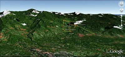
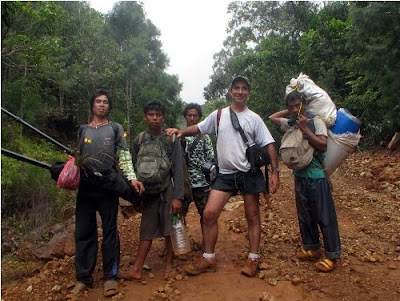
On July 2009, a mission led by the Philippine-based Ancestral Land/Domain Watch (ALDAW) and the Centre for Biocultural Diversity (CBCD) at the University of Kent traveled to the eastern side of the Gantong range, in Brooke’s Point Municipality, Province of Palawan. Palawan is part of the “Man and Biosphere Reserve” program of UNESCO and hosts 49 animals and 56 botanical species found in the IUCN Red List of Threatened Species.

The mission’s actual ‘matching’ of collected GPS data to photographs shows that the Mineral Production Sharing Agreements (MPSA) of two mining firms [MacroAsia and Celestial Nickel Mining and Exploration Corporation (CNMEC) now operated by Ipilan Nickel Corporation (INC)] overlap with precious watersheds endowed with numerous creeks, springs and waterfalls providing potable water to the local indigenous communities and lowland farmers. More importantly, under the ECAN Guidelines of the Strategic Environmental Plan for Palawan (Republic Act 7611), such areas constitute the so called “core zones” of maximum protection where industrial extractive activities are not allowed.

At an altitude of about 500m ASL the mission reached indigenous settlements inhabited by very traditional Palawan having limited contacts with the outside. Their sustenance totally depends on the available forest resources, and it consists of a heterogeneous economy where sustainable swidden cultivation is integrated with foraging and the collection of non-timber forest products (NTFPs).


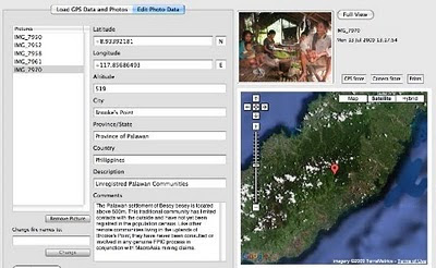
Overall, the mission moved from an elevation of a few meters ASL to an altitude of about 670m ASL, where one of the furthermost Palawan settlements is located. The mission’s GPS coordinates were obtained through the use of the JOBO GPS device being connected to the camera’s hot shoe. Positions were taken at intervals of several meters in order to reconstruct the mission’s full itinerary. The geo-tagged images were then loaded into ‘Photo GPS Editor’ and displayed on satellite Google map. All upland Palawan interviewed during the ALDAW/CBCD mission have declared that they have never been consulted about the entrance of mining companies in their traditional territories.


According to indigenous representatives, the Palawan branch of the National Commission on Indigenous Peoples (NCIP) – the government body mandated to ‘protect and promote the interest and well-being of cultural communities’ – is now siding with the mining companies. It is hoped that the ALDAW/CBCD Gantong geo-tagged report will facilitate the circulation of information, at both the national and international levels, on the threats faced by ‘irresponsible mining’ in the Philippines’ “last frontier”. An international campaign to support indigenous Palawan claims to their ancestral land has also been initiated by Survival International.

Source: The ALDAW NETWORK

The ALDAW NETWORK (Ancestral Land/Domain Watch) is an advocacy-campaign network of Indigenous Peoples jointly constituted by NATRIPAL (United Tribes of Palawan) and BANGSA PALAWAN PHILIPPINES (Indigenous Alliance for Equity and Wellbeing) on August 2009.

Saturday, October 17, 2009

Educational Video ob CyberTracker - Tracking in the Cyber Age

The CTA recently released an educational video on CyberTracker technology. The video has been produced in the context of the development of a training kit aimed at supporting the spread of good practice in generating, managing, analysing and communicating spatial information. This 8-min video on CyberTracker covers a number of uses to which geospatial information technology (GIT) can be put to work in the contexts of development and conservation.

CyberTracker is an open-source software developed in South Africa by the Cybertracker Conservation with financial support initially provided of by the European Commission. It can be installed on a GPS-enabled handheld device such as a Personal Digital Assistant (PDA) or a Smartphone to collect geo-referenced data with detailed digital notation. It is a highly efficient way to gather large quantities of geo-coded field observations at a speed and level of detail not possible before. CyberTracker allows users to customise the interface to meet data collection needs. Screen designs can combine text and icons to optimise efficiency and customisation. The CyberTracker icon interface was originally designed for trackers who could not read or write. Nowadays all users including scientists and conservationists benefit from the icon-based interface because it enables significantly faster data entry.

Thursday, October 01, 2009

Francis Kakwetin Lesingo reports on the use of a 1:10,000 scale 3D model in Nessuit Kenya

Mr. Francis Kakwetin Lesingo - a representative from the Ogieks living in the Mau complex (Nakuru,Kenya) - reports back on the use of a 1:10,000 scale georeferenced physical 3d model manufactured by 26 ogiek clans in 2006 and 2007 in Nessuit Kenya. The initiative has benefitted from technical and financial assistance provided by CTA, Ermis Africa, the Indigenous Peoples of Africa Coordinating Committee (IPACC) and the Gaia Foundation UK.

Friday, September 18, 2009

Web-Based GIS and the Future of Participatory GIS Applications within Local and Indigenous Communities

As resource managers search for strategies to meet the challenges posed by intense competition for scarce local resources, the implementation of Community-based GIS applications have become widespread. Besides mapping, the Participatory GIS (PGIS) projects create a peaceful medium for community groups and public officials to meet, exchange views and also learn to develop trust for each other. However, PGIS projects face many problems including the lack of basic supporting infrastructure and services. The adoption of the Internet as a platform for PGIS applications therefore raises concerns about the future of PGIS projects. While the Internet may open the participatory process, it can also hinder participation among local groups. In an era when PGIS applications have become important in the management of local resources, there is an urgent need to examine implications of the On-line PGIS project. Accordingly, in their paper, by the title Web-Based GIS and the Future of Participatory GIS Applications within Local and Indigenous Communities, Peter Kyem and James Saku assess the potential benefits and drawbacks of on-line PGIS applications within local communities.

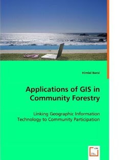
Applications of GIS in Community Forestry: Linking Geographic Information Technology to Community Participation

Planning and managing forest resources in todays ever-changing world is becoming very complex and demanding challenges to forest resource managers. Because of the multiple interests of forest users and other community interest groups, a wider range of up-to-date information is being requested in community forestry, than has been used in conventional government-based forest management in the past. Geographic Information Systems (GIS) and related technologies provide foresters and resource planners with powerful tools for planning, management and decision making. Recent trend towards community based forest management has added new dimensions and potential to use of GIS in community forestry. This book explores the potential and constraints for the application of GIS technology in community based forestry. This book will be of interest to forest managers, community development practitioners, researchers and students interested in using GIS technology in forestry and participatory GIS.

Tuesday, September 01, 2009

Qualitative GIS: A Mixed Methods Approach

'Qualitative GIS is coming of age, and this definitive collection explains why it deserves broad attention. These carefully selected essays by leading researchers, organized around a broad conception of qualitative GIS that extends beyond multi-media data integration to embrace new software tools and interpretive, situated epistemologies, will push readers to rethink not only their preconceptions about qualitative GIS, but also about GI science and critical GIS. GIS researchers, practitioners, observers and users will find much to chew on here' - Professor Eric Sheppard, University of Minnesota, USA

Geographic Information Systems are an essential tool for analyzing and representing quantitative spatial data. Qualitative GIS explains the recent integration of qualitative research with Geographical Information Systems

With a detailed contextualising introduction, the text is organised in three sections:

Representation: examines how researchers are using GIS to create new types of representations; working with spatial data, maps, and othervisualizations to incorporate multiple meanings and to provide texture and context. This section includes a chapter by Jon Corbett and Giacomo Rambaldi dealing with participatory mapping by the title: "Geographic information technologies, local knowledge, and change (pages 75-91).

Analysis: discusses the new techniques of analysis that are emerging at the margins between qualitative research and GIS, this in the wider context of a critical review of mixed-methods in geographical research

Theory: questions how knowledge is produced, showing how ideas of 'science' and 'truth' inform research, and demonstrates how qualitative GIS can be used to interrogate discussions of power, community, and social action

Making reference to representation, analysis, and theory throughout, the text shows how to frame questions, collect data, analyze results, and represent findings in a truly integrated way. An important addition to the mixed methods literature, Qualitative GIS will be the standard reference for upper-level students and researchers using qualitative methods and Geographic Information Systems.

Available from Amazon.com (US) and Amazon.co.uk (Europe)