Showing posts with label participation. Show all posts

Monday, May 21, 2012

Day 1: Participatory Mapping and Community Empowerment for Climate Change Adaptation, Planning and Advocacy

21 May, 2012, HONIARA - “Of course we know a lot about our land and sea, but we didn’t realise just how much we do actually know ...” representatives of Chivoko community of Choiseul province, Solomon Islands, pointed out after the Participatory 3D Modelling (P3DM) exercise was completed. As we discovered today, P3DM goes far beyond making a map; it is a process that, if efficiently and correctly used, can become a powerful tool to give voice to those people that over time have being excluded from decision-making processes within the mainstream society.

The “Participatory Mapping and Community Empowerment for Climate Change Adaptation, Planning and Advocacy, an Orientation and Project Planning Workshop” opened today in Honiara, Solomon Islands.

Organized by the Technical Centre for Agriculture and Rural Cooperation ACP-EU (CTA), in partnership with The Nature Conservancy UNDP Solomon, Partners with Melanesia (PwM) and three UNDP Co-funded projects, namely Strengthen Environment Management and Reducing the Impact of Climate Change (SEMRICC); Strogen Waka lo Community fo Kaikai (SWoCK) and Pacific Adaptation for Climate Change (PACC), the event brought together more than 80 people from 17 countries, including Australia, Cook Islands, Federated Sates of Micronesia, Fiji, Italy, The Netherlands, New Zealand, Palau, Papua New Guinea, Philippines, Samoa, Solomon Islands, St. Vincent and the Grenadines, Trinidad and Tobago, UK, USA and Vanuatu.

Hon. Rense Sore, Permanent Secretary of MECDM
opens the event
The workshop was opened by Rense Sore, Permanent Secretary of the Ministry of Environment, Climate Change, Disaster Management and Meteorology (MECDM).

His intervention was followed by the one delivered by Dr. Douglas Lee, Director Climate Change Division (MECDM) who introduced the recently developed National Climate Change Policy for Solomon Islands and the one by David Hiriasia, Director Meteorology (MECDM).

The sessions of the day combined presentations on participatory mapping methods and their use, with group exercises and open spaces for interactive information sharing; a practical session on P3DM enfolded in parallel: assisted by a facilitator,  students from the Naro community started assembling a 1:5000 scale model of their village. Once completed, the model will be populated by elders coming from the village. Once finalised the model will include a traditional coastal conservation area (tambu area) located in front of the main settlement.

This activity will allows workshop participants to have a factual experience of what a participatory 3D mapmaking process is all about, students to acquire a new skill, and finally villagers to gain access to an updated, scaled and geo-referenced replica of their territory for further development and use .

The today’s focus of the event was on opportunities and challenges of practicing Participatory GIS in developing countries, especially when assessing climate change impacts and adaptation measures.

As different experiences of P3DM carried out around the world reveal, participatory mapping can be a key instrument for local and indigenous communities to document and express their local knowledge and to communicate it through a visual language easily understandable for outsiders. In this sense, the power of the maps embraces at the same time the risks of doing mapping itself: if, on the one hand, participatory mapping process can enable local communities to give visibility to their valuable knowledge and thus to increase their contribution in influencing decision-making processes, on the other hand, the translation of local knowledge into public information, and out of local control, might lead to undesired exploitation or generate conflicts.


If misused, in fact, information shown on maps might open up the door to outsiders to take control over local resources. This is why it is fundamental to carefully consider risks and benefits and to set clear objectives with communities before carrying out participatory mapping activities, as Giacomo Rambaldi (CTA) pointed out. This will help to find ways to safeguard local knowledge, keeping some of the sensitive information confidential, and to mitigate risks.


Over time, participatory mapping activities in general, and P3DM in particular, have been undertaken in different parts of the world to address different issues, from self-determination of local communities to the management of territorial conflicts, from land titling to community based planning and management, including participatory watershed planning and management, hazard management and climate change adaptation, among others.

Among the P3DM experiences presented today, those in the Pacific Region mostly focussed on climate change adaptation. For many communities, participatory 3D models have been important tools to understand their land and the gradual impacts of climate change on traditional territories, as well as to envisage possible future scenarios and take informed actions. Over time, indigenous and local communities have developed climate change adaptation practices based on existing knowledge and on observation of the natural phenomena. In this context, P3DM can be used as a tool to merge indigenous knowledge with available science and technology to best deal with and mitigate climate change impacts. In the case of the community of Boe Boe, Solomon Islands, as its representatives reported, the model helped villagers to identify the raise of the sea level and the progressive erosion of the coastline; based on this observations, the community decided to not longer build houses on the coast while moving to the inland instead. The P3DM exercise in Boe Boe, supported by The Nature Conservancy, was successful in facilitating community land use planning and the sustainable management of natural resources. But this was not the only outcome the P3DM activity achieved.

As Winifred Pitamama, Boe Boe’s representative, stressed out "during the P3DM process women and children learned a lot about our area. The model showed our sacred places, our inland before our ancestors moved to the coast, where to collect shell, where to fish (…). But, especially it helped women to best plan for the future. At the beginning it was a bit challenging for women, because they don’t raise their concerns, they are generally quite (…). This has been a tool to share our views”. As a teacher, Winifred is using the model for educational purposes in her work with children. “They learn to recognize their places” she said. As in Boe Boe, other communities made use of the participatory 3D models to better understand their territories, what was affecting them and to raise awareness about those issues.

This is the case of Indigenous Peoples in the Philippines, that were able to visualise the potential impact of a large scale mining operation scheduled to take place within their ancestral domains and to induce the local government to stop the intervention, as Dave de Vera (PAFID) reported.

Therefore, P3DM becomes a powerful tool to visualise the past, the present and the future, to analyse the movement of natural resources and to design action plans to protect or stimulate the restoration of resources, appointing people to monitor the process in the future.

An initiative supported by:
Read more:


Sunday, September 18, 2011

A Participatory Video made by Chivoko Village, Solomon Islands


Conservation Story Blong Chivoko" was made by the men and women of the remote coastal village of Chivoko, accessible only by sea on the north-west tip of Choiseul Island, one of the Solomon Islands. Chivoko's tribal land is one of the last remaining intact and unlogged forests in the Solomon islands. Their reefs are important spawning sites for the grouper fish which come to lay their eggs every year for 2 months around May. Their story is an insight into the problems they are facing with increased pressure from logging companies, increasing population, declining forest and marine resources, and ensuing climate change. They provide solutions which may help other Solomon Island and other communities around the world, to also safeguard the abundance of resources for future generations to come ...

More information on a Participatory 3D Model done in Chivoko village in 2009 is available here.

Thursday, June 02, 2011

CCE Talks: Community-Based Mapping Tools - Nina-Marie Lister


Nina-Marie Lister is an Associate Professor of Urban and Regional Planning at Ryerson University and Visiting Associate Professor at Harvard University Graduate School of Design. She presents on mapping projects that relate landscape, ecology and urbanism and enable communities to decide what is mapped, for whom and for what purpose.

Presented by the Centre for City Ecology

May 18th, 2011

Urbanspace Gallery, Toronto

Friday, March 04, 2011

Training Kit on Participatory Spatial Information Management and Communication

Online version released - Co-published by CTA and IFAD, this Training Kit is a unique product that can be tailored to meet your needs, ensuring that your employees get the best training available on Participatory Spatial Information Management and Communication.

The Training Kit contains 15 Modules, each presented through a series of Units. Modules cover the entire spectrum of good developmental practice – from mobilising communities to developing a communication strategy based on the outcome of participatory mapping activities.

The Modules touch on topics such as the fundamentals of training, ethics and community groundwork and processes as well as the more technical low-, mid- and high-tech participatory mapping methods. The Training Kit culminates in a Module on networking, communication and advocacy – the pillars upon which maps become effective media and negotiation tools.

You decide what you want to cover and when. This product has been developed using the Multimedia Training Kit (MMTK) approach – you pick and choose those Modules, Units and components that best suit your particular requirements and develop a curriculum to suit your specific needs.

Publishers: Technical Centre for Agricultural and Rural Co-operation ACP-EU (CTA), Wageningen, The Netherlands and International Fund for Agricultural Development (IFAD), Rome, Italy

Year of Publication: 2010

Monday, January 17, 2011

Looking Through a Mirror at our Past and Present: Account of a P3DM Exercise in Ethiopia

The leathery scent at the venue hall was nothing more than the confirmation that we were working in rural Ethiopia, in a village called Telecho, some 30 kilometres north of Holeta. We had just gathered with 20 delegates coming from Ethiopia, Kenya, Tanzania, South Africa, Uganda, Cameroon and Benin to co-facilitate a participatory mapping exercise implemented by more than 130 villagers coming from 28 kebeles located within the area and foothills of a mountain known as Foata.

The exercise – organised by MELCA-Ethiopia, a national NGO and supported by the Technical Centre for Agricultural and Rural Cooperation ACP-EU (CTA), was a response to a call by the community for assistance in rehabilitating its environment which suffered heavy deforestation and soil degradation over the past decades. After several month of preparation, the exercise took place on 8-18 December 2010 in the village of Telecho amidst a golden landscape shimmering with wheat, teff and rye at maturity stage intersected by dark brown strips of ploughed land and exposed soil cloths weltering in the choking sun.

Close to 140 people worked in shifts on the model which covers – at a 1:10,000-scale - a total area of 672 sq km including portions of four woredas namely Welmera, Ejere, Adea berga and Mulo. Assisted by the trainers, 14 students, three teachers and the foreign delegates (the trainees) manufactured the blank model. Approximately 110 elders representing 28 kebeles contributed in overlapping groups to the elaboration of the map legend and the depicting of their mental maps onto the model. A number of representatives from local government units contributed to the exercise as well.

The assembling of the blank model using 3-mm thick sheets of carton board and measuring 2.8m x 2.4m, took three days while the depiction of the landscape and the location of features relevant to the community, took additional six days.

Selected elders introduced the first group of participants to the draft legend which was verified and further enriched in terms of items and their descriptors. Once completed, the model stored 48 layers of information including 25 point-, 5 line- and 18 area types. A count of point data done at the end of the exercise revealed that within the area there were 38 schools, 23 health posts, 113 sacred trees, 8 markets, 861 settlements and much more.

In terms of process, villagers from the first group introduced the second group to its task and the latter did the same with the third group. This ensured a full transfer of ownership of the entire process from the facilitators, who kick-started the process, to the informants, which proudly presented their output to the wider community and government representatives on the day of the inauguration and closing ceremony. Villagers worked with great attention and passion while depicting the landscape of their woredas. Animated discussions, exchanges, and negotiations characterised the process involving both men (the majority) and women. Traditional dances animated the start of the activities in the morning while work kept on rolling until night at the light of a generator.

A bull was slaughtered in anticipation of the closing ceremony which took place on 18 December 2010. The event signified the apotheosis of the process where elders (man and women) presented the legend and information featured on the 3D model and described the process which led to its production. The audience was composed of approximately 300 villagers originating from all 28 woredas, representatives from the parliament, local government, CTA, the Finnish Embassy and delegates coming from 9 African countries, representing NGOs and universities.

During the various phases of model making, participants were given the chance to express themselves and provide written feedback on the process using so called “democracy walls”. Democracy walls are large sheets of craft paper labelled as “I noticed”, “I learned”, “I discovered”, “I felt”, “I would like to suggest” where individuals can stick A5 sheets of paper where they have marked a statement related to the “label” and concerning the process experienced. In addition a professional media team documented the process and conducted interviews, and a group of youth was trained and assisted in producing a Participatory Video (PV).

Participating villagers reported that working on the model elicited powerful memories of a past landscape characterised by lush forests and permanent river courses, and made them realise how much the conversion of the matural habitat had impacted (negatively) on their life. Participants stated that through a self-reflection process they realised that their non-sustainable handling of the resources base had led to impoverishment of soils and decrease in crop yield, and that the present situation was threatening their livelihoods and mere subsistence. They stated that the process of model building created learning environment and gave them a sense of purpose. “The P3DM process enables the community to look at itself using the model as a mirror” wrote a villager on a card featuring on the “Democracy Walls”.

Written statements made by villagers (in Amharic) while working on the 3D model:

“I felt that - as we destroyed the natural resources in our surroundings, we lost the soil, the forest, wild animals and more. This in turn is harming ourselves and creating problems to coming generations”.
“I felt that I could compare what we did on the map with what existed in the past [in the real world], and this makes it clearer about what to do in the future”.
“I noticed that it [the process] helped me understanding the importance of participation. I also realized that the community has valuable knowledge that we were not aware of.” 
“I noticed that the P3DM process enables the community to look at itself using the model as a mirror. It builds capacities and that is important for the development of the country.”

Source: Democracy Walls, Telecho, 17 December 2010

The large gathering on 18 December reinforced the message as villagers involved in the mapmaking shared their realisations, increased awareness and statements of intentions. The presence of Government representatives who seemed bewildered by the view of the model at its unveiling, was much appreciated by the community members, and reinforced their perception of being considered and listen to in their pledge for working jointly for a better future. In this context villagers decided to convene a larger meeting to look into a series of actions which would help them rehabilitate their degraded land.

A few days after the completion of the exercise, MELCA was granted additional financial support by the Finnish Embassy to sustain follow-up activities related to the rehabilitation of the environment in the project area. The 3D model will play an important part in this process as it represents the most updated and most relevant repository of local spatial information and a planning tool which can be easily mastered at village level, as it is fully understood and endorsed by the local populace.

Last but not least, the national and international trainees expressed their intention to replicate the process in their areas.

Authors: Giacomo Rambaldi / CTA and Million Belay MELCA-Ethiopia
Images: G. Rambaldi / CTA© and Damian Prestidge / CTA©


Notre passé et notre présent au travers d'un miroir : récit d'un exercice de CP3D en Éthiopie

La senteur de cuir qui émanait du lieu de la manifestation n'était que la confirmation du fait que nous étions au cœur de l'Éthiopie rurale, dans un village du nom de Telecho, à quelques 30 kilomètres au nord d'Holeta. Nous venions de nous réunir avec 20 délégués en provenance d'Éthiopie, du Kenya, de Tanzanie, d'Afrique du Sud, d'Ouganda, du Cameroun et du Bénin pour co-animer un exercice de cartographie participative mis en œuvre par plus de 130 villageois originaires de 28 kebeles situés autour d'une montagne connue sous le nom de Foata.

L'exercice, organisé par l'ONG nationale MELCA-Ethiopia avec l'appui du Centre technique de coopération agricole et rurale ACP-UE (CTA), constituait la réponse à un appel à l'aide de la communauté, qui souhaitait réhabiliter son environnement après plusieurs décennies de déforestation et de dégradation importante des sols. Après plusieurs mois de préparation, l'exercice s'est déroulé du 8 au 18 décembre 2010 dans le village de Telecho, au milieu d'un paysage doré riche en blé, en teff et en seigle mûrs et entrecoupé de bandes foncées de terre labourée et de tissus de sols exposés au soleil.


Cartographie pour le changement. Expérience des agriculteurs dans la zone rurale d’Oromiya, Éthiopie from CTA on Vimeo.

Près de 140 personnes ont travaillé en équipes sur la maquette qui couvre une surface rurale totale de 672 km², à l'échelle 1:10,000, y compris des portions de quatre woredas : Welmera, Ejere, Adea berga et Mulo. Assistés par les formateurs, 14 étudiants, trois enseignants et les délégués étrangers (les stagiaires) ont élaboré la maquette vierge. Environ 110 anciens, représentants de 28 kebeles, ont contribué par groupes à l'élaboration de la légende de la carte et au report de leurs cartes mentales sur la maquette. Un certain nombre de représentants d'entités du gouvernement local ont également participé à l'exercice.

L'assemblage de la maquette vierge avec des plaques de carton de 3 mm d'épaisseur mesurant 2,8 m x 2,4 m a pris trois jours et la description du paysage et la localisation des caractéristiques pertinentes pour la communauté, six jours supplémentaires.

Certains anciens ont présenté le projet de légende au premier groupe de participants qui l'ont vérifiée et enrichie par de nouveaux éléments et leurs descripteurs. Une fois terminé, le modèle comprenait 48 couches d'informations, dont 25 types de point, 5 types de ligne et 18 types de zone. Un calcul du nombre de points de données réalisé au terme de l'exercice a révélé que la zone comptait 38 écoles, 23 postes de santé, 113 arbres sacrés, 8 marchés, 861 villages et bien plus encore.

Pour ce qui est du processus, les villageois du premier groupe ont expliqué la tâche au deuxième groupe et celui-ci a fait de même pour le troisième groupe. Cette méthode a permis le transfert de la maîtrise de l'ensemble du processus des animateurs, qui ont lancé la formation, vers les détenteurs du savoir local, qui ont fièrement présenté leurs résultats à l'ensemble de la communauté et aux représentants gouvernementaux le jour de l'inauguration et de la cérémonie de clôture. Les villageois ont œuvré avec beaucoup d'attention et de passion en décrivant le paysage de leurs woredas. Des discussions, des échanges et des négociations animées ont caractérisé le processus, auquel ont participé des hommes (en majorité) et des femmes. Les activités débutaient par des danses traditionnelles le matin et le travail se poursuivait jusqu'à la nuit tombée, à la lumière d'un générateur.

Un taureau a été abattu en prévision de la cérémonie de clôture qui s'est déroulée le 18 décembre 2010. Cet événement a été l'apothéose d'un processus où des anciens (homme et femmes) ont présenté la légende et les informations contenues dans la maquette 3D et décrit le processus qui a sous-tendu sa production. Le public était composé d'environ 300 villageois originaires de 28 woredas, de représentants du parlement, du gouvernement local, du CTA, de l'ambassade finnoise et de délégués d'ONG et d'universités de 9 pays africains.

Au cours des diverses phases d'élaboration de la maquette, les participants ont pu s'exprimer et écrire leur ressenti sur le processus au travers des « murs de la démocratie ». Les murs de la démocratie sont de grandes feuilles de papier intitulées « J'ai remarqué », « J'ai appris », « J'ai découvert », « J'ai senti », « Je voudrais suggérer », sur lesquelles les participants peuvent coller des feuilles A5 où ils inscrivent un commentaire lié à l'intitulé et concernant le processus. De plus, une équipe média professionnelle a documenté le processus et mené des entretiens, tandis qu'un groupe de jeunes a été formé et a participé à la production d'une vidéo participative (VP).

Les villageois participants ont rapporté que le travail sur la maquette avait réveillé en eux des souvenirs de paysages passés de forêts luxuriantes et de cours d'eau permanents, ce qui leur a permis de réaliser combien la transformation de l'habitat naturel avait eu un impact (négatif) sur leur vie. Les participants ont affirmé que grâce à un processus d'introspection, ils ont compris que leur exploitation non durable des ressources avait entraîné l'appauvrissement des sols et une baisse des rendements agricoles, et que la situation actuelle menaçait leur moyens d'existence et même leur subsistance. Ils ont ajouté que le processus d'élaboration du modèle créait un cadre d'apprentissage et leur donnait le sentiment d'avoir un but. « Le processus CP3D permet à la communauté de se regarder en utilisant le modèle comme miroir », a écrit un villageois sur une carte collée sur les « Murs de la démocratie ».

Voici des exemples de commentaires écrits par les villageois (en amharic) alors qu'ils travaillaient sur la maquette :

« Je sentais que - avec la destruction des ressources naturelles dans notre environnement - nous avons perdu la terre, la forêt, les animaux sauvages et bien plus encore. Cela nous porte préjudice et pose des problèmes aux générations futures. »

« Je sentais que nous pouvions comparer ce que nous avions fait sur la carte avec ce qui existait par le passé [dans la réalité], et cela clarifie ce qu'il faut faire à l'avenir. »

« J'ai remarqué qu'il [le processus] m'aidait à comprendre l'importance de la participation. J'ai également réalisé que la communauté disposait d'un savoir précieux dont nous n'avions pas conscience. »

« J'ai remarqué que le processus CP3D permet à la communauté de se regarder en utilisant le modèle comme miroir. Il renforce les capacités et c'est important pour le développement du pays. » (Source : Murs de la démocratie, Telecho, 17 décembre 2010)

La grande réunion du 18 décembre a renforcé le message car les villageois impliqués dans la cartographie ont partagé leurs réalisations, développé leur conscientisation et exprimé davantage de déclarations d'intention. La présence de représentants du gouvernement, quelque peu abasourdis à la vue du modèle lors de son dévoilement, a été fort appréciée des membres de la communauté et a renforcé leur sentiment d'être considérés et écoutés dans leur engagement de collaboration pour un meilleur avenir. Dans ce contexte, les villageois ont décidé d'organiser une réunion avec un public plus large afin d'examiner un ensemble d'actions qui contribuerait à réhabiliter leurs terres victimes de dégradations.

Quelques jours après la fin de l'exercice, l'ambassade finnoise a octroyé une aide financière supplémentaire à la MELCA en vue de mettre sur pied des activités de suivi portant sur la réhabilitation de l'environnement dans la région concernée par le projet. La maquette 3D jouera un rôle important dans cette partie du processus car il représente le référentiel le plus actualisé et pertinent regroupant des informations sur l'espace local ainsi qu'un outil de planification facile à maîtriser par les villageois, puisqu'il est parfaitement compris et approuvé par la population locale.

Enfin, point très encourageant, les stagiaires nationaux et internationaux ont manifesté leur intention de réitérer le processus dans leur région.

Auteurs : Giacomo Rambaldi / CTA et Million Belay MELCA-Ethiopia

Version anglaise

Friday, December 10, 2010

Groundbreaking Participatory Spatial Information Management and Communication Training Kit launched

The first ever training kit for Participatory Spatial Information Management and Communication was launched today after weeks of excited pre-ordering online. Co-published by CTA and IFAD, this training kit is a unique product that can be tailored to meet the learning needs of the individual, group or organisation.

‘This is a hugely exciting training tool for the development sector,’ commented Giacomo Rambaldi, Senior Programme Coordinator at CTA. ‘It means that employees can now get the best available training tailored to meet their individual needs.’

The training kit comprises 15 modules, each presented through a series of units. They cover the entire spectrum of good developmental practice. The modules deal with topics such as fundamentals of training, ethics and community groundwork and processes as well as the more technical low-, mid- and high-tech participatory mapping methods.

The Training Kit is featured on the CTA Publications catalogue. Available in English and Spanish, it is aimed at technology intermediaries working in multidisciplinary teams, and for those required to deliver training on the practice or facilitate the process in the field.

The benefits of this type of mapping are numerous. Mapmaking is considered as a step in a broader process resulting in community empowerment by adding value and authority to local spatial knowledge. The process leading to the production of maps is in fact more important than the outputs themselves, as knowledge holders learn by doing. The practice is motivating and often leads to stronger identity and cohesion among community members. Moreover, maps are a powerful and convincing medium which can be used to effectively convey local concerns and aspirations to decision- and policy makers.

This project is another example of CTA’s dedication to empowering rural communities through knowledge. The success of the training kit also demonstrates the benefits CTA enjoys through working with partners such as IFAD to deliver high quality information to a wider audience.

If you are interested in getting a copy of the Training Kit you may send an e-mail to Murielle Vandreck vandreck@cta.int adding PGIS-TK (English / Spanish) to the e-mail subject line.

Online versions: coming soon
DVD versions: CTA online catalogue

Thursday, December 02, 2010

Participatory 3-Dimensional Modelling: Guiding Principles and Applications; 2010 edition

The Technical Centre for Agricultural and Rural Cooperation ACP-EU (CTA) recently released a new edition of the handbook "Participatory 3D Modelling: Guiding Principles and Applications; 2010 Edition”. The Global Environment Facility (GEF) Small Grants Programme (SGP) supported its French and Spanish versioning. The documents are now available in three languages as free downloads at high and medium resolutions.
Participatory three-dimensional modelling (P3DM) is a participatory mapping method integrating indigenous spatial knowledge with data on elevation of the land and depth of the sea to produce stand-alone, scaled and geo-referenced 3D models. Essentially based on recollections from memory, land use and cover and other features are depicted by informants on the model by using push pins for points, yarns for lines and paints for polygons. On completion, a scaled and geo-referenced grid is applied to facilitate data extraction or importation. Data depicted on the model are extracted, digitised and plotted. On completion of the mapping exercise, the model remains with the community.

P3DM has been conceived as a method for bringing the potential of GIS closer to rural communities and for bridging the gap that exists between geographic information technologies and capacities found among marginalised and isolated communities who are frequently dependent on natural resources.

This handbook is intended to assist activists, researchers and practitioners of participatory learning and action (PLA) and GIS in bringing the power of GIS to the grassroots level through the use of P3DM. It provides hands-on guidelines on how to organise and implement a P3DM exercise. In addition it includes insights on adult learning and spatial cognition, on the history of relief models and on the use of the method around the world.


On 5 November 2007, P3DM was granted the World Summit Award 2007 in the category of e-culture. P3DM was considered to be one of the 40 best practice examples of quality e-content in the world.

Versión en francésVersión en español  | English version

Wednesday, August 04, 2010

Sekadau Consensus: Community Mapping in West Kalimantan, Indonesia


The documentary describes a process wherein the Dayak communities in Nanga Mahap, Sekadau District of Indonesia get control and manage their territories and succeed in stopping the expansion of palm oil plantations.

Participatory mapping and spatial planning were used to build new consensus between the communities and the local government at village and sub-District and District level.

The new consensus was built after the communities gained a clearer understanding on the impact of the industrial palm oil plantations on land tenure and on the cultural, economic and ecological sustainability of their villages.

Video and description courtesy Kasmita Widodo, Jaringan Kerja Pemetaan Partisipatif (JKPP).

Thursday, July 29, 2010

Recreando nuestra Cultura, Mapeando nuestro Futuro


El cuento de un encuentro especial en Venda, Sur Africa, y un proceso comunitario de cartografía eco-cultural. Líderes indígenas del Altai (Rusia) y la Amazonía Colombiana, juntos con representantes de ONGs de Sur Africa, Kenia y Etiopía, acompañan a la comunidad de Tshidvizhe mientras que descubren una sencilla pero poderosa manera de expresar el pasado y el presente de su territorio  en mapas hechos a mano. Los mapas destacan la importancia de su cultura, los sitios sagrados, el territorio y sus modos de vida, y empoderan a la comunidad mapear el futuro por lo cual deben luchar.

Tuesday, February 23, 2010

Ethics are central to community-based mapping processes


Dr. Nigel Crawhall, Director of Secretariat at the Indigenous Peoples of Africa Coordinating Committee (IPACC), a pan-African network, elaborates on the value of ethics in the context of participatory mapping processes.

More on practical ethics in PPGIS/PGIS practice is found here.

Tuesday, February 02, 2010

Metodología participativa para construir una maqueta 3D en Telpaneca, Nicaragua

Este video trata sobre la construcción de una maqueta (un mapa en 3 dimensiones) de un territorio rural. Se basa en una experiencia que se dió con pueblos indígenas en los territorios de Telpaneca, en Nicaragua.


El video es una producción de la Unión Nacional de Agricultores y Ganaderos (UNAG) de Nueva Segovia, y la ONG francesa Agrónomos y Veterinarios Sin Fronteras (AVSF).

Saturday, January 23, 2010

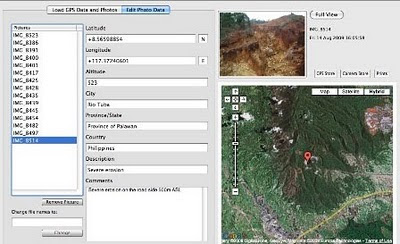
Counter-mapping in the Philippines: The Gantong Geo-Tagged Report

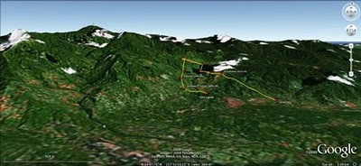
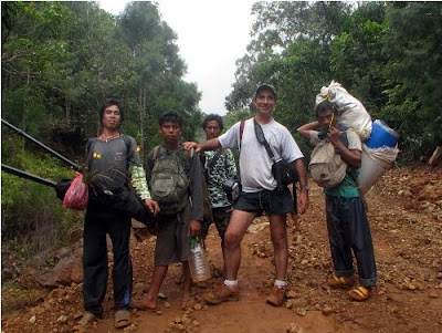
On July 2009, a mission led by the Philippine-based Ancestral Land/Domain Watch (ALDAW) and the Centre for Biocultural Diversity (CBCD) at the University of Kent traveled to the eastern side of the Gantong range, in Brooke’s Point Municipality, Province of Palawan. Palawan is part of the “Man and Biosphere Reserve” program of UNESCO and hosts 49 animals and 56 botanical species found in the IUCN Red List of Threatened Species.

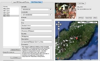
The mission’s actual ‘matching’ of collected GPS data to photographs shows that the Mineral Production Sharing Agreements (MPSA) of two mining firms [MacroAsia and Celestial Nickel Mining and Exploration Corporation (CNMEC) now operated by Ipilan Nickel Corporation (INC)] overlap with precious watersheds endowed with numerous creeks, springs and waterfalls providing potable water to the local indigenous communities and lowland farmers. More importantly, under the ECAN Guidelines of the Strategic Environmental Plan for Palawan (Republic Act 7611), such areas constitute the so called “core zones” of maximum protection where industrial extractive activities are not allowed.

At an altitude of about 500m ASL the mission reached indigenous settlements inhabited by very traditional Palawan having limited contacts with the outside. Their sustenance totally depends on the available forest resources, and it consists of a heterogeneous economy where sustainable swidden cultivation is integrated with foraging and the collection of non-timber forest products (NTFPs).


Overall, the mission moved from an elevation of a few meters ASL to an altitude of about 670m ASL, where one of the furthermost Palawan settlements is located. The mission’s GPS coordinates were obtained through the use of the JOBO GPS device being connected to the camera’s hot shoe. Positions were taken at intervals of several meters in order to reconstruct the mission’s full itinerary. The geo-tagged images were then loaded into ‘Photo GPS Editor’ and displayed on satellite Google map. All upland Palawan interviewed during the ALDAW/CBCD mission have declared that they have never been consulted about the entrance of mining companies in their traditional territories.


According to indigenous representatives, the Palawan branch of the National Commission on Indigenous Peoples (NCIP) – the government body mandated to ‘protect and promote the interest and well-being of cultural communities’ – is now siding with the mining companies. It is hoped that the ALDAW/CBCD Gantong geo-tagged report will facilitate the circulation of information, at both the national and international levels, on the threats faced by ‘irresponsible mining’ in the Philippines’ “last frontier”. An international campaign to support indigenous Palawan claims to their ancestral land has also been initiated by Survival International.

Source: The ALDAW NETWORK

The ALDAW NETWORK (Ancestral Land/Domain Watch) is an advocacy-campaign network of Indigenous Peoples jointly constituted by NATRIPAL (United Tribes of Palawan) and BANGSA PALAWAN PHILIPPINES (Indigenous Alliance for Equity and Wellbeing) on August 2009.

Thursday, January 21, 2010

The Bulanjao Geotagged Report

On August 2009, a mission led by the Philippines-based Ancestral Land/Domain Watch (ALDAW) and the Centre for Biocultural Diversity (CBCD) at the University of Kent traveled to Barangay Sumbiling, Municipality of Bataraza, Province of Palawan (Philippines).

Geo-referenced audio-visual and photographic documentation was carried out in the Bulanjao range whose vegetation consists of a very unique type of forest growing on ultramafic /heavy-metal rich soils. The area is home to at least four plant species that are classified as vulnerable and two of them have already been included in the IUCN Red List.

In spite of its unique ecological features, the Bulanjao range has been subjected to mineral exploration and development by the Rio Tuba Nickel Mining Corporation (RTNMC). RTNMC is a Filipino-Japanese partnership holding a mining concession area of about 5,265 hectares.

RTNMC and its partner, Coral Bay Nickel Corporation (CBNC), need to mine nickel ores as part of the expansion of their new Hydrometallurgical Processing Plant (HPP) project. However, one the conditions specified in the Environmental Compliance Certificate (ECC) issued to them in 2002, is that “core zones” - as identified by the Strategic Environmental Plan for Palawan (Republic Act Republic Act 7611) should not be included in the areas of mining operations and, this, of course includes the Bulanjao range.

Starting at an elevation of about 40m ASL, the ALDAW/CBCD mission followed the mining road to reach the highest portions of the Bulanjao range. Geo-tagging evidence indicates that erosion on the Bulanjao mining road is occurring also at low elevations. During the rainy season the water creates deep clefts on the roadsides, hence penetrating the soil and fostering road collapse. No mitigating measures have been put into place to reduce erosion. A huge crater-like excavation has been found at 566m ASL. and land slides, induced by road construction, have been documented around the sources of the Sumbiling river, at almost 900m ASL. The latter is the most important water source for both lowland farmers and indigenous communities.

Marylin Samparan, a local IP living in the area told the mission: “time will come when our children will no longer recognize the names of trees, the footprints of animals, the birds’ songs. This will be the time when the forest will be gone, the mining companies will be gone, the rivers will no longer flow…and us? We will still be here”.

On 15 August 2009, the mission established that mining road had already reached an altitude of 859m ASL – and its exact location was defined through the following GPS coordinates (+ 8.59322548 N Latitude and + 117.36516571 E Longitude).

Mission’s findings have now been compiled into a geo-tagged report, which is being used by local indigenous communities to support their legal struggle against mining in Bulanjao.

Source: The ALDAW NETWORK

The ALDAW NETWORK (Ancestral Land/Domain Watch) is an advocacy-campaign network of Indigenous Peoples jointly constituted by NATRIPAL (United Tribes of Palawan) and BANGSA PALAWAN PHILIPPINES (Indigenous Alliance for Equity and Wellbeing) on August 2009.

Friday, October 23, 2009

Dr. Robert Chambers elaborates on Participatory GIS (PGIS) practice


Dr. Robert Chambers from the Institute of Development Studies (IDS), UK, reflects on the intersection of participatory development and Geographic Information Systems (GIS) and on the resulting good and bad practices. In the interview Dr. Chambers calls on practitioners and development agencies to ensure that good practice is put in place to avoid the repetition of the misuse of PRA (i.e. Participatory Rural Appraisal) done in the 80's and 90's.

Thursday, October 22, 2009

The future of environmental law mapping

Laurent Granier from ecocy recently wrote an essay on the future of environmental law mapping where he argues GIS and mapping tools are transforming our vision of legal data, “from vertical books to horizontal maps”. Drawing on examples of online mapping tools and representations, including participatory GIS, he shows a tendency for law and policy makers to aggregate administrative and legal layers in maps, towards more and more legally binding tools.

Saturday, October 17, 2009

Educational Video ob CyberTracker - Tracking in the Cyber Age

The CTA recently released an educational video on CyberTracker technology. The video has been produced in the context of the development of a training kit aimed at supporting the spread of good practice in generating, managing, analysing and communicating spatial information. This 8-min video on CyberTracker covers a number of uses to which geospatial information technology (GIT) can be put to work in the contexts of development and conservation.

CyberTracker is an open-source software developed in South Africa by the Cybertracker Conservation with financial support initially provided of by the European Commission. It can be installed on a GPS-enabled handheld device such as a Personal Digital Assistant (PDA) or a Smartphone to collect geo-referenced data with detailed digital notation. It is a highly efficient way to gather large quantities of geo-coded field observations at a speed and level of detail not possible before. CyberTracker allows users to customise the interface to meet data collection needs. Screen designs can combine text and icons to optimise efficiency and customisation. The CyberTracker icon interface was originally designed for trackers who could not read or write. Nowadays all users including scientists and conservationists benefit from the icon-based interface because it enables significantly faster data entry.

Thursday, October 01, 2009

Francis Kakwetin Lesingo reports on the use of a 1:10,000 scale 3D model in Nessuit Kenya

Mr. Francis Kakwetin Lesingo - a representative from the Ogieks living in the Mau complex (Nakuru,Kenya) - reports back on the use of a 1:10,000 scale georeferenced physical 3d model manufactured by 26 ogiek clans in 2006 and 2007 in Nessuit Kenya. The initiative has benefitted from technical and financial assistance provided by CTA, Ermis Africa, the Indigenous Peoples of Africa Coordinating Committee (IPACC) and the Gaia Foundation UK.

Wednesday, September 30, 2009

The Touch Table for participatory land use planning

This video shows how the Touch Table can be used to support land use planning with multiple stakeholders with multiple interests

Friday, September 18, 2009

Web-Based GIS and the Future of Participatory GIS Applications within Local and Indigenous Communities

As resource managers search for strategies to meet the challenges posed by intense competition for scarce local resources, the implementation of Community-based GIS applications have become widespread. Besides mapping, the Participatory GIS (PGIS) projects create a peaceful medium for community groups and public officials to meet, exchange views and also learn to develop trust for each other. However, PGIS projects face many problems including the lack of basic supporting infrastructure and services. The adoption of the Internet as a platform for PGIS applications therefore raises concerns about the future of PGIS projects. While the Internet may open the participatory process, it can also hinder participation among local groups. In an era when PGIS applications have become important in the management of local resources, there is an urgent need to examine implications of the On-line PGIS project. Accordingly, in their paper, by the title Web-Based GIS and the Future of Participatory GIS Applications within Local and Indigenous Communities, Peter Kyem and James Saku assess the potential benefits and drawbacks of on-line PGIS applications within local communities.