I have just come across the report prepared in December 2006 by the special rapporteur on the situation of human rights and fundamental freedoms of indigenous people in Kenya. Considering the current situation in Mau, I thought that it would be worth adding visibility to this public document.
I am quoting part of the text and offer a link to the full document at the bottom of this post.
...
C. Hunter-gatherers and forest peoples
36. Settlement schemes, logging and charcoal production have put a severe strain on Kenya’s rich and varied forests, and have resulted in the loss of the traditional habitat of Kenya’s forest peoples, the indigenous hunter-gatherers such as the Awer (Boni), Ogiek, Sengwer, Watta, and Yaaku. While existing laws are oriented to the protection of wildlife and forest resources, many of these communities can no longer live by their traditional livelihoods, and their cultures and language are rapidly vanishing as a result; illegal logging has played a major role in this as well.
37. The way of life of the Ogiek is well adapted to the Mau Forest environment where they have lived for centuries. Numbering about 20,000 countrywide, they have been dispersed and assimilated in recent decades, and dispossessed of their traditional source of livelihood. When the Mau Forest was gazetted as a National Forest in 1974, the Ogiek were evicted from their traditional habitat without prior consultation or compensation, in violation of their basic human rights. They were henceforth prevented from hunting or collecting bee honey for survival in the forest, and were reduced to a miserable subsistence on the margins of this area rich in plants and wildlife. On the other hand, illegal logging, the introduction of exotic plantations and the excision of parts of the forest for private development by outside settlers have endangered the Mau Forest as a water catchment area, as well as the country’s environmental security. The Special Rapporteur on adequate housing, Miloon Kothari, signalled in his report on his mission to Kenya that the destruction of the forest has affected the rights of the Ogiek to housing, health, food and a safe environment, threatening to further destroy their cultural identity and the community as a whole (see E/CN.4/2005/48/Add.2, para. 61).
38. Despite a court injunction in their favour in 1997, the Government has proceeded to alienate Ogiek forest land, and a recent court decision does not recognize the Ogiek’s ancestral title to the forest. Still, the Government has distributed title deeds to land to several thousand Ogiek, and some non-Ogiek outsiders have tried to enrol as Ogieks in the hope that they may eventually also be given title deeds. The unresolved conflict between the Ogiek and their neighbours continues to this day. Being considered as squatters on their own land and legally banned from using the forest resources for their livelihood, their attempt to survive according to their traditional lifestyle and culture has often been criminalized and their repeated recourse to the courts has not been successful. Ogiek attribute this vulnerability to the fact that they are not recognized as a distinct tribe and therefore lack political representation. The Special Rapporteur met with members of several Ogiek villages, listened to their grievances and heard their demands for the recognition of their right to land and to maintain their traditional lifestyle in the forest.
...
90. In view of the above, the Special Rapporteur makes the following recommendations:
A. Recommendations to the Government
...
Forest areas
102. The rights of indigenous hunter-gatherer communities (particularly the Ogiek in Mau Forest) to occupy and use the resources in gazetted forest areas should be legally recognized and respected. Further excisions of gazetted forest areas and evictions of hunter-gatherers should be stopped. Titles derived from illegal excision or allocation of forest lands should be revoked, and new titles should only be granted to original inhabitants. Illegal commercial logging should be stopped.
C. Recommendations to indigenous communities and organizations
...
124. Indigenous peoples’ organizations are encouraged to develop concrete strategies for data collection, research and documentation to support their advocacy work both at the national and international levels.
D. Recommendations to civil society and political parties
...
127. NGOs and donors should strengthen their relations with indigenous communities, support their development initiatives and promote a better understanding of their demands and aspirations within Kenyan society.
...
Read / download the full document.

Wednesday, February 10, 2010
Monday, February 08, 2010
Knowledge and cultural transmission in Kenyan participatory mapping
In this 5 minute interview Dr. Nigel Crawhall, Director of Secretariat at IPACC, elaborates on intergenerational ecological knowledge transmission in Participatory 3-dimensional modelling (P3DM). Crawhall discusses his observations on intergenerational interaction when the Ogiek community of Nessuit, Kenya built a geo-referenced model of their mountain forest landscape in 2006.
Sunday, February 07, 2010
Geographic Information Science and Public Participation
 Computer-mediated participation is at the crossroads. In the early heady days of the digital revolution, access to "high" technologies such as GIS promised the empowerment of marginalized communities by providing data and information that was previously hidden away from public view. To a great extent, this goal has been achieved at least in the U.S. and Western Europe – data about a range of government initiatives and raw data about different aspects of spatial planning such as land use, community facilities, property ownership are available a mouse-click away. Now, that the public, have access to information, are we able to make better plans for the future of our cities and regions? Are we more inclusive in our planning efforts? Are we able to foster collaborative governance structures mediated by digital technologies?
In Geographic Information Science and Public Participation (Advances in Geographic Information Science)
The foreword for the book is written by Prof. Bill Huxhold.
Tuesday, February 02, 2010
Digital Cartography
Digital Cartography from dynamicmediainstitute.org on Vimeo.
By Andrew Ellis, Alexander Wang, Students at the Dynamic Media Institute, Massachusetts College of Art and Design
Digital Cartography is a short documentary film on the transition of maps into their digital form. In this film we speak with programmer and mapmaker Jeffrey Warren from the MIT Media Lab and Dietmar Offenhuber from SENSEable City Lab at MIT. We explore the cultural, economic and technical aspects of mapmaking and how they affect the way we communicate with one another.
In our interviews with Jeffrey and Dietmar we learn about the social and geographical ramifications of building maps and how designers can implement their literacy in communication design to explore different avenues for mapping. Participatory mapping such as Open Street Maps and psychogeography and the virtual dérive are some of the themes discussed around the history and future of mapping in the digital age. Jeffrey gives us a demonstration on low cost arial photography using a helium balloon and a consumer digital camera to stitch photos onto google maps.
Metodología participativa para construir una maqueta 3D en Telpaneca, Nicaragua
Este video trata sobre la construcción de una maqueta (un mapa en 3 dimensiones) de un territorio rural. Se basa en una experiencia que se dió con pueblos indígenas en los territorios de Telpaneca, en Nicaragua.
El video es una producción de la Unión Nacional de Agricultores y Ganaderos (UNAG) de Nueva Segovia, y la ONG francesa Agrónomos y Veterinarios Sin Fronteras (AVSF).
El video es una producción de la Unión Nacional de Agricultores y Ganaderos (UNAG) de Nueva Segovia, y la ONG francesa Agrónomos y Veterinarios Sin Fronteras (AVSF).
Monday, February 01, 2010
Community Mapping in Tsunami Affected Areas in Aceh, Indonesia
A touching 10-minute video production on how community mapping has been used in post-Tsunami Aceh, Indonesia.
The documentary has been jointly produced by the Indonesia Community Mapping Network or Jaringan Kerja Pemetaan Partisipatif (JKPP), and the Center for people Economic Development or Yayasan Rumpun Bambu Indonesia (YRBI).
More videos on participatory mapping are found here.
The documentary has been jointly produced by the Indonesia Community Mapping Network or Jaringan Kerja Pemetaan Partisipatif (JKPP), and the Center for people Economic Development or Yayasan Rumpun Bambu Indonesia (YRBI).
More videos on participatory mapping are found here.
Sunday, January 31, 2010
CyberTracker releases a sample database for Disaster Relief Rapid Surveying
Cape Town, South Africa. A sample database for Disaster Relief can be downloaded and modified for specific relief efforts from the CyberTracker Conservation website
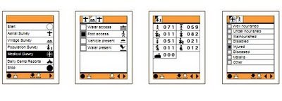 The CyberTracker software can be installed on GPS-enabled Windows Mobile smartphones.
This may help to gather crucial data required to co-ordinate disaster relief logistics.
One of the critical problems in disaster relief management is the lack of reliable data on basic needs on the ground after a major natural disaster. Disaster relief efforts must overcome serious logistical problems due to poor communication and unreliable information. Gathering good quality data on the ground will make it possible to make informed decisions on where the highest priorities are.
Better information on quantities of relief supplies needed, such as medicines, food, blankets, shelter and clothing will ensure that resources are used more efficiently where they are needed most.
Source: Louis Liebenberg, CyberTracker Conservation
Saturday, January 30, 2010
Indigenous People’s Exchanges Amongst Philippines and Peru Promoted by CBCD and ALDAW
Through A Christensen Fund grant “Linking Networks on Pastoralism and Mobile production systems”, Dario Novellino (research at the Centre for Biocultural Diversity (CBCD) of the University of Kent and CEESP member) has facilitated the establishment of solidarity links between the indigenous communities of Palawan and those of Madre de Dios (Peru) who have resisted and are resisting mining for more than two decades.
 The establishment of this linkage took place right at the time when indigenous peoples of the Amazonian Peru had began various forms of open resistance against hydrocarbon extraction in their traditional territories. The solidarity link between the IPs of Peru and Palawan is being consolidated through the collaboration of the Ancestral Land/Domain Watch (ALDAW), the Peoples and Plants International (PPI) and, specifically, through the personal efforts of Dr. Miguel Alexiades (CBCD staff and PPI co-director). Such exchange promotes the sharing of experiences as a way of 1) fostering reflection and joint actions through the establishment of strategic alliances; and 2) addressing common problems regarding indigenous links, rights and claims over ancestral homelands and cultural landscapes.
 The envisaged goal is to enable the production of jointly produced video materials that could be used to exert pressure at a national and international policy level.
Julio Cusurichi, representing the indigenous organization COINBAMAD (Consejo Indigena de la Cuenca Baja de Madre De Dios) and winner of the well-known award, the Goldman Prize - arrived in the Philippines on July 2009, leaving the country after 21 days. He traveled to Palawan (Philippines) accompanied by Dr. Novellino and the ALDAW (Ancestral Domain/Land Watch) staff. In Palawan, local indigenous organizations (Bangsa Palawan Philippines and NATRIPAL) facilitated the dialogue between Julio and different Palawan communities, while Dr. Novellino helped in the simultaneous translation from Spanish to Palawan language. During his stay, Julio met many indigenous leaders and communities’ members (including women and children) and shared his experience and lessons regarding the impacts of mining and other forms of commercial extractivism upon cultural landscapes and ancestral homelands. Participatory videos showing the impact of mining and oil extraction in Madre de Dios (Peru) have been shown also to the most isolated Palawan communities.
Through Julio’s visit, a process of direct exchange between grassroots indigenous mobilization in Madre de Dios, Peru and local indigenous anti-mining movements in Palawan has been initiated. Before Julio’s departure, this collaboration has been formalized in a Memorandum of Understanding. Video shootings made by Julio Cusurichi in Palawan have been taken back to Peru and will be shown to the Amazonian indigenous communities. A cross-visit of Palawan representatives to the Peruvian Amazon has been planned for the year 2010.
Saturday, January 23, 2010
Counter-mapping in the Philippines: The Gantong Geo-Tagged Report
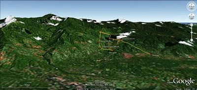
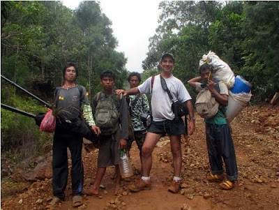
On July 2009, a mission led by the Philippine-based Ancestral Land/Domain Watch (ALDAW) and the Centre for Biocultural Diversity (CBCD) at the University of Kent traveled to the eastern side of the Gantong range, in Brooke’s Point Municipality, Province of Palawan. Palawan is part of the “Man and Biosphere Reserve” program of UNESCO and hosts 49 animals and 56 botanical species found in the IUCN Red List of Threatened Species.
 The mission’s actual ‘matching’ of collected GPS data to photographs shows that the Mineral Production Sharing Agreements (MPSA) of two mining firms [MacroAsia and Celestial Nickel Mining and Exploration Corporation (CNMEC) now operated by Ipilan Nickel Corporation (INC)] overlap with precious watersheds endowed with numerous creeks, springs and waterfalls providing potable water to the local indigenous communities and lowland farmers. More importantly, under the ECAN Guidelines of the Strategic Environmental Plan for Palawan (Republic Act 7611), such areas constitute the so called “core zones” of maximum protection where industrial extractive activities are not allowed.
At an altitude of about 500m ASL the mission reached indigenous settlements inhabited by very traditional Palawan having limited contacts with the outside. Their sustenance totally depends on the available forest resources, and it consists of a heterogeneous economy where sustainable swidden cultivation is integrated with foraging and the collection of non-timber forest products (NTFPs).
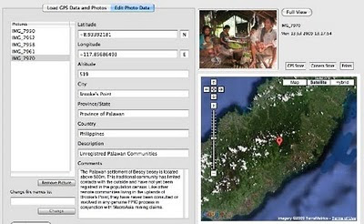
Overall, the mission moved from an elevation of a few meters ASL to an altitude of about 670m ASL, where one of the furthermost Palawan settlements is located. The mission’s GPS coordinates were obtained through the use of the JOBO GPS device being connected to the camera’s hot shoe. Positions were taken at intervals of several meters in order to reconstruct the mission’s full itinerary. The geo-tagged images were then loaded into ‘Photo GPS Editor’ and displayed on satellite Google map. All upland Palawan interviewed during the ALDAW/CBCD mission have declared that they have never been consulted about the entrance of mining companies in their traditional territories.
According to indigenous representatives, the Palawan branch of the National Commission on Indigenous Peoples (NCIP) – the government body mandated to ‘protect and promote the interest and well-being of cultural communities’ – is now siding with the mining companies. It is hoped that the ALDAW/CBCD Gantong geo-tagged report will facilitate the circulation of information, at both the national and international levels, on the threats faced by ‘irresponsible mining’ in the Philippines’ “last frontier”. An international campaign to support indigenous Palawan claims to their ancestral land has also been initiated by Survival International.
Source: The ALDAW NETWORK
The ALDAW NETWORK (Ancestral Land/Domain Watch) is an advocacy-campaign network of Indigenous Peoples jointly constituted by NATRIPAL (United Tribes of Palawan) and BANGSA PALAWAN PHILIPPINES (Indigenous Alliance for Equity and Wellbeing) on August 2009.
 The mission’s actual ‘matching’ of collected GPS data to photographs shows that the Mineral Production Sharing Agreements (MPSA) of two mining firms [MacroAsia and Celestial Nickel Mining and Exploration Corporation (CNMEC) now operated by Ipilan Nickel Corporation (INC)] overlap with precious watersheds endowed with numerous creeks, springs and waterfalls providing potable water to the local indigenous communities and lowland farmers. More importantly, under the ECAN Guidelines of the Strategic Environmental Plan for Palawan (Republic Act 7611), such areas constitute the so called “core zones” of maximum protection where industrial extractive activities are not allowed.
At an altitude of about 500m ASL the mission reached indigenous settlements inhabited by very traditional Palawan having limited contacts with the outside. Their sustenance totally depends on the available forest resources, and it consists of a heterogeneous economy where sustainable swidden cultivation is integrated with foraging and the collection of non-timber forest products (NTFPs).

Overall, the mission moved from an elevation of a few meters ASL to an altitude of about 670m ASL, where one of the furthermost Palawan settlements is located. The mission’s GPS coordinates were obtained through the use of the JOBO GPS device being connected to the camera’s hot shoe. Positions were taken at intervals of several meters in order to reconstruct the mission’s full itinerary. The geo-tagged images were then loaded into ‘Photo GPS Editor’ and displayed on satellite Google map. All upland Palawan interviewed during the ALDAW/CBCD mission have declared that they have never been consulted about the entrance of mining companies in their traditional territories.

According to indigenous representatives, the Palawan branch of the National Commission on Indigenous Peoples (NCIP) – the government body mandated to ‘protect and promote the interest and well-being of cultural communities’ – is now siding with the mining companies. It is hoped that the ALDAW/CBCD Gantong geo-tagged report will facilitate the circulation of information, at both the national and international levels, on the threats faced by ‘irresponsible mining’ in the Philippines’ “last frontier”. An international campaign to support indigenous Palawan claims to their ancestral land has also been initiated by Survival International.
Source: The ALDAW NETWORK

The ALDAW NETWORK (Ancestral Land/Domain Watch) is an advocacy-campaign network of Indigenous Peoples jointly constituted by NATRIPAL (United Tribes of Palawan) and BANGSA PALAWAN PHILIPPINES (Indigenous Alliance for Equity and Wellbeing) on August 2009.
Friday, January 22, 2010
Peter Poole traces the evolution of participatory map-making
In this interview, Dr. Peter Poole traces the evolution of a participatory map-making which commenced with the introduction of GPS to the Inuits in 1989 and evolved throughout the 1990s via a series of projects in the Amazon, the Arctic and Asia.
Tenure maps depict indigenous names, resources and special places on scaled maps, intended as evidence in negotiating processes. Peter describes the search for cheap, simple, appropriate geomatic technology. Community-based teams would gather raw field data and indigenous associations or support NGOs, set up mapping units to serve the field teams.
Three lessons are described: (i) communities can make their own scaled maps, (ii) emerging mapping centres should make their services accessible to all communities, (iii) this methodology not only produces a tenure map, but also equips and inspires community mappers to diversify their skills in environmental information management.
Thursday, January 21, 2010
The Bulanjao Geotagged Report
On August 2009, a mission led by the Philippines-based Ancestral Land/Domain Watch (ALDAW) and the Centre for Biocultural Diversity (CBCD) at the University of Kent traveled to Barangay Sumbiling, Municipality of Bataraza, Province of Palawan (Philippines).
Geo-referenced audio-visual and photographic documentation was carried out in the Bulanjao range whose vegetation consists of a very unique type of forest growing on ultramafic /heavy-metal rich soils. The area is home to at least four plant species that are classified as vulnerable and two of them have already been included in the IUCN Red List.
 In spite of its unique ecological features, the Bulanjao range has been subjected to mineral exploration and development by the Rio Tuba Nickel Mining Corporation (RTNMC). RTNMC is a Filipino-Japanese partnership holding a mining concession area of about 5,265 hectares.
RTNMC and its partner, Coral Bay Nickel Corporation (CBNC), need to mine nickel ores as part of the expansion of their new Hydrometallurgical Processing Plant (HPP) project. However, one the conditions specified in the Environmental Compliance Certificate (ECC) issued to them in 2002, is that “core zones” - as identified by the Strategic Environmental Plan for Palawan (Republic Act Republic Act 7611) should not be included in the areas of mining operations and, this, of course includes the Bulanjao range.
 Starting at an elevation of about 40m ASL, the ALDAW/CBCD mission followed the mining road to reach the highest portions of the Bulanjao range. Geo-tagging evidence indicates that erosion on the Bulanjao mining road is occurring also at low elevations. During the rainy season the water creates deep clefts on the roadsides, hence penetrating the soil and fostering road collapse. No mitigating measures have been put into place to reduce erosion. A huge crater-like excavation has been found at 566m ASL. and land slides, induced by road construction, have been documented around the sources of the Sumbiling river, at almost 900m ASL. The latter is the most important water source for both lowland farmers and indigenous communities.
Marylin Samparan, a local IP living in the area told the mission: “time will come when our children will no longer recognize the names of trees, the footprints of animals, the birds’ songs. This will be the time when the forest will be gone, the mining companies will be gone, the rivers will no longer flow…and us? We will still be here”.
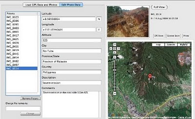
On 15 August 2009, the mission established that mining road had already reached an altitude of 859m ASL – and its exact location was defined through the following GPS coordinates (+ 8.59322548 N Latitude and + 117.36516571 E Longitude).
 Mission’s findings have now been compiled into a geo-tagged report, which is being used by local indigenous communities to support their legal struggle against mining in Bulanjao.
Source: The ALDAW NETWORK
The ALDAW NETWORK (Ancestral Land/Domain Watch) is an advocacy-campaign network of Indigenous Peoples jointly constituted by NATRIPAL (United Tribes of Palawan) and BANGSA PALAWAN PHILIPPINES (Indigenous Alliance for Equity and Wellbeing) on August 2009.
Geo-referenced audio-visual and photographic documentation was carried out in the Bulanjao range whose vegetation consists of a very unique type of forest growing on ultramafic /heavy-metal rich soils. The area is home to at least four plant species that are classified as vulnerable and two of them have already been included in the IUCN Red List.
 In spite of its unique ecological features, the Bulanjao range has been subjected to mineral exploration and development by the Rio Tuba Nickel Mining Corporation (RTNMC). RTNMC is a Filipino-Japanese partnership holding a mining concession area of about 5,265 hectares.
RTNMC and its partner, Coral Bay Nickel Corporation (CBNC), need to mine nickel ores as part of the expansion of their new Hydrometallurgical Processing Plant (HPP) project. However, one the conditions specified in the Environmental Compliance Certificate (ECC) issued to them in 2002, is that “core zones” - as identified by the Strategic Environmental Plan for Palawan (Republic Act Republic Act 7611) should not be included in the areas of mining operations and, this, of course includes the Bulanjao range.
 Starting at an elevation of about 40m ASL, the ALDAW/CBCD mission followed the mining road to reach the highest portions of the Bulanjao range. Geo-tagging evidence indicates that erosion on the Bulanjao mining road is occurring also at low elevations. During the rainy season the water creates deep clefts on the roadsides, hence penetrating the soil and fostering road collapse. No mitigating measures have been put into place to reduce erosion. A huge crater-like excavation has been found at 566m ASL. and land slides, induced by road construction, have been documented around the sources of the Sumbiling river, at almost 900m ASL. The latter is the most important water source for both lowland farmers and indigenous communities.
Marylin Samparan, a local IP living in the area told the mission: “time will come when our children will no longer recognize the names of trees, the footprints of animals, the birds’ songs. This will be the time when the forest will be gone, the mining companies will be gone, the rivers will no longer flow…and us? We will still be here”.
On 15 August 2009, the mission established that mining road had already reached an altitude of 859m ASL – and its exact location was defined through the following GPS coordinates (+ 8.59322548 N Latitude and + 117.36516571 E Longitude).
 Mission’s findings have now been compiled into a geo-tagged report, which is being used by local indigenous communities to support their legal struggle against mining in Bulanjao.
Source: The ALDAW NETWORK
The ALDAW NETWORK (Ancestral Land/Domain Watch) is an advocacy-campaign network of Indigenous Peoples jointly constituted by NATRIPAL (United Tribes of Palawan) and BANGSA PALAWAN PHILIPPINES (Indigenous Alliance for Equity and Wellbeing) on August 2009.
Tuesday, January 19, 2010
What 3-D mapmakers should know about expanded EVA / PE closed-cell foam or sponge
 Expanded EVA / PE closed-cell foam or sponge is usually made out of a blend of Ethylene Vinyl Acetate copolymer (also known as EVA) and polyethylene. The product is a lightweight foam material which has a smooth surface and does not absorb water. Generally EVA sheeting is priced competitively, compared with other blown materials and is available in different densities, thicknesses and colours.
It is one of the materials most popularly known as expanded rubber or foam rubber sheeting.
EVA foam is used to produce - among others - mouse pads, flip flops and sports mats. Sheets of the material can be used for manufacturing Participatory 3D Models.
Models made out of this material are well suited for humid tropical environments where carton board may deteriorate rapidly.
Manufacturing a 3D model using 'expanded EVA / PE closed-cell foam' compared to carton board implies a slightly higher cost and non biodegradable debris, but ensures a more durable output and a consistent vertical scale/exaggeration of the 3D model. Insertion of map and push pins is easy.
More information on the topic is found here.
Friday, January 08, 2010
Interview with Steve deRoy about the role of networking and communication in PGIS practice
In this interview, Mr. Steven DeRoy illustrates the power of networking and the importance of integrating this practice into the daily realm of PGIS. These professional exchanges create an opportunity to dialogue with likeminding professionals, allowing practitioners to share ideas and approaches to solve common challenges. Maps also play a vital role in communicating ideas amongst different parties and for advocating change in current affairs
Google Earth Outreach initiative in Africa
 Google Earth Outreach in Africa was recently launched with the objective of enabling non-profit and public benefit organizations in the continent to access the knowledge and resources they need to organize their data, build their maps, tell their stories through geographic visualization.
Google Earth and the various Google Geo Tools are increasingly used for communication and advocacy because of their unique ability to visually connect people to places.
By annotating Google Earth and Maps with pictures and information, organizations can tell visual and compelling stories of the work they do to the over 500 million Google Earth users.
Monday, December 14, 2009
Community mapping in Borneo
 Community members and park naturalists have completed a participatory 3-dimensional scaled model of the Buayan-Kionop area showing areas important for community livelihoods. The pproject, funded by the Darwin Initiative, is designed to contribute to the nomination of the Crocker Range Biosphere Reserve. Work began in August 2009 with local partners and 10 indigenous communities. Local researchers from Buayan-Kionop are sharing their skills with neighbouring communities to document and map community livelihood patterns for the entire Ulu Papar area. They have been using a range of techniques, including participatory GIS and participatory 3-dimensional modelling (P3DM) to show areas important for cultivation, hunting, fishing and gathering of forest products. Over the next 3 years, we will build on the participatory research results in Buayan-Kionop and create spaces for community dialogue on balancing conservation and sustainable resource use in the Crocker Range.
More information on the programme is found here.
Source: Agnes Lee Agama, Southeast Asia coordinator, Global Diversity Foundation update December 2009
Friday, November 27, 2009
Eco-cultural mapping to protect natural resources and sacred sites, South Africa
The case of the vhaVenda people echoes throughout many other rural areas in Africa and amongst other groups of traditional and indigenous peoples – the loss of communally owned territories, the expansion of industrial plantations and non-sustainable forms of land and resource use including tourism, the erosion of cultural values and sacred sites. 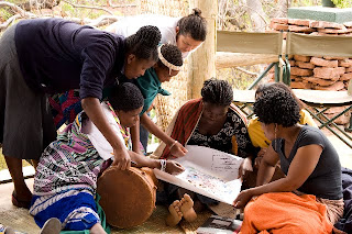 With support from CTA, women, men and youth from Tshidzivhe community, in Limpopo province, northern South Africa, spent six days exploring ways to ‘map’ their traditional knowledge and practices for managing their natural resources. As the different maps were finished, the local people celebrated their new capacity to express traditional environmental knowledge in an appropriate way for gaining recognition, reviving traditional practices and securing their rights.
This was a unique mapping experience that involved local people as well as indigenous from other parts of the world. More than 70 vhaVenda people took part, guided by trainers in eco-cultural mapping from Colombia and accompanied by indigenous leaders from the Colombian Amazon and the Russian Republic of Altai. The process required the full participation of community members, especially the elders and the makhadzis, women custodians of sacred sites, but with minimal materials or technology.
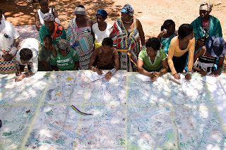 Four maps and two ecological calendars were produced, covering what the local population refers to as “Venda territory” and with special attention to the main sacred sites. The maps show the changes and alterations to the land - the past, present and future visions - and the importance of recovering traditional practices and rituals.
Trainees from Kenya and Ethiopia, members of the African Biodiversity Network, took part and hope to carry out similar workshops in their respective countries in 2010.
Photos by Will Baxter, text by Fiona Wilton / The Gaia Foundation
 With support from CTA, women, men and youth from Tshidzivhe community, in Limpopo province, northern South Africa, spent six days exploring ways to ‘map’ their traditional knowledge and practices for managing their natural resources. As the different maps were finished, the local people celebrated their new capacity to express traditional environmental knowledge in an appropriate way for gaining recognition, reviving traditional practices and securing their rights.
This was a unique mapping experience that involved local people as well as indigenous from other parts of the world. More than 70 vhaVenda people took part, guided by trainers in eco-cultural mapping from Colombia and accompanied by indigenous leaders from the Colombian Amazon and the Russian Republic of Altai. The process required the full participation of community members, especially the elders and the makhadzis, women custodians of sacred sites, but with minimal materials or technology.
 Four maps and two ecological calendars were produced, covering what the local population refers to as “Venda territory” and with special attention to the main sacred sites. The maps show the changes and alterations to the land - the past, present and future visions - and the importance of recovering traditional practices and rituals.
Trainees from Kenya and Ethiopia, members of the African Biodiversity Network, took part and hope to carry out similar workshops in their respective countries in 2010.
Photos by Will Baxter, text by Fiona Wilton / The Gaia Foundation
Saturday, November 21, 2009
Ogieks will not be evicted from the Mau forest
As reported by NTVKenya on October 24, 2009 , it is emerging that members of the Ogiek indigenous community will not be affected by the eviction notice. the Mau task force committee says the indigenous forest dwellers will not be moved when the evictions start soon. The announcement came as the Prime Minister gunned for more financial support for the Mau in Europe.
Related news and actions on PPgis.Net Blog:
Ogiek Appeal to the Kenya Government Notice to vacate Mau Forest Complex and other water towers
The 2009 UNESCO World Report on Cultural Diversity makes reference to the Ogiek 3D Mapping
Francis Kakwetin Lesingo reports on the use of a 1:10,000 scale 3D model in Nessuit Kenya
More on indigenous mapping by Ogiek People in the Mau Forest
Friday, November 13, 2009
Peter Poole reports on his experience with community mapping
In this interview, Peter Poole traces the evolution of a map-making methodology which commenced with his introduction of GPS to the Inuit community of Pangnirtung in 1989 and was incubated throughout the 1990’s by a series of ‘tenure mapping’ projects in the Amazon the Arctic and Asia. Tenure maps depict indigenous names, resources and special places on scaled maps, intended as evidence in negotiating land settlements.
Most tenure mapping methods rely upon external cartographic expertise. The “no-name” method enables communities to control the complete information cycle: gathering raw data, their conversion to information, its application.
The interview describes the search for cheap, simple, appropriate geomatic technology.
During several tenure mapping projects in the Amazon, a two-tier arrangement evolved whereby community-based teams would gather raw field data, the most critical task, and indigenous associations or support NGO’s, set up mapping units to serve the field teams.
The interview shifts focus to an overview of global community mapping completed by Peter Poole. In this, he concluded that, in terms of expertise, accessibility and accomplishment, the Philippines. He also drew a broad distinction to tenure mapping in America, a continent whose indigenous peoples sharing a in common ‘500 years since Columbus’ experience, and Africa, where this model does not work and where community mapping is taking off in a refreshing variety of directions.
The interview concludes with three lessons learned:
- Yes, communities can make their own scaled maps.
- The most successful of emerging mapping centres are those whose services are accessible to all communities.
- This capacity-building approach to map making equips and inspires people to diversify their skills in environmental information management. These skills will be wasted unless provisions are made to follow up tenure mapping projects with either further training or employment.
Saturday, November 07, 2009

Friday, November 06, 2009
Dave De Vera elaborates on Participatory GIS practice in the Philippines
Dave De Vera is the Executive Director of the Philippine Association For Intercultural Development (PAFID). In his interview Dave elaborates on the use of Participatory GIS practice in the Philippines to support indigenous communities in filing ancestral land claims. He elaborates on the mapping methods used, explains why P3DM is the most effective, and arguments on the need for local ownership of the process, competency of the technology intermediary, quality work, and constructive relationships with Government. Dave further lists cases of PAFID / Government partnerships and analyses the pillars of process legitimization.
Subscribe to:
Posts (Atom)